1992 Suusamyr earthquake
 USGS ShakeMap | |
 | |
| UTC time | 1992-08-19 02:04:37 |
|---|---|
| ISC event | 278018 |
| USGS-ANSS | ComCat |
| Local date | 19 August 1992 |
| Local time | 08:04:37 KGT (UTC+6) |
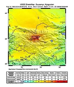
| Magnitude | Ms 7.3 |
| Depth | 27.4 km (17.0 mi) |
| Epicenter | 42°08′31″N 73°34′30″E / 42.142°N 73.575°E |
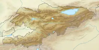
| Areas affected | Kyrgyzstan, Tajikistan, Uzbekistan, Kazakhstan and China |
| Max. intensity | MMI IX (Violent) |
| Casualties | 75 deaths |
The 1992 Suusamyr earthquake occurred at 08:04:37 KGT (02:04:37 UTC) on 19 August near Toluk in the border area of Kyrgyzstan. The shock had a surface-wave magnitude of 7.3 and a maximum felt intensity of IX (Violent) on the Mercalli intensity scale. It was a result of reverse faulting.[1] The death toll from the event amounted to about 75, including 14 people who were killed by landslides.
See also
References
- ^ ANSS. "M 7.3 - 60 km ENE of Toktogul, Kyrgyzstan 1992". Comprehensive Catalog. U.S. Geological Survey.
Further reading
- Gómez, J. M.; Bukchin, B.; Madariaga, R.; Rogozhin, E. A.; Bogachkin, B. (1997), "Rupture process of the 19 August 1992 Susamyr, Kyrgyzstan, earthquake", Journal of Seismology, 1 (3): 219–235, Bibcode:1997JSeis...1..219G, doi:10.1023/A:1009780226399
- Grützner, Christoph; Walker, Richard; Ainscoe, Eleanor; Elliott, Austin; Abdrakhmatov, Kanatbek (2019-06-21). "Earthquake Environmental Effects of the 1992 MS7.3 Suusamyr Earthquake, Kyrgyzstan, and Their Implications for Paleo-Earthquake Studies". Geosciences. 9 (6): 271. doi:10.3390/geosciences9060271. ISSN 2076-3263.
External links
- The International Seismological Centre has a bibliography and/or authoritative data for this event.