Zadní Chodov
Zadní Chodov | |
|---|---|
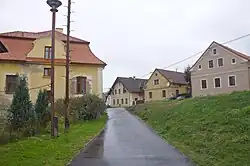 Houses in Zadní Chodov | |
 Flag  Coat of arms | |
 Zadní Chodov Location in the Czech Republic | |
| Coordinates: 49°53′26″N 12°39′17″E / 49.89056°N 12.65472°E | |
| Country | |
| Region | Plzeň |
| District | Tachov |
| First mentioned | 1365 |
| Area | |
• Total | 13.88 km2 (5.36 sq mi) |
| Elevation | 517 m (1,696 ft) |
| Population (2025-01-01)[1] | |
• Total | 245 |
| • Density | 18/km2 (46/sq mi) |
| Time zone | UTC+1 (CET) |
| • Summer (DST) | UTC+2 (CEST) |
| Postal code | 348 15 |
| Website | www |
Zadní Chodov (German: Hinter Kotten) is a municipality and village in Tachov District in the Plzeň Region of the Czech Republic. It has about 200 inhabitants.
Zadní Chodov lies approximately 11 kilometres (7 mi) north of Tachov, 56 km (35 mi) west of Plzeň, and 130 km (81 mi) west of Prague.
Administrative division
Zadní Chodov consists of two municipal parts (in brackets population according to the 2021 census):[2]
- Zadní Chodov (173)
- Kyjov (48)
Demographics
| Year | Pop. | ±% |
|---|---|---|
| 1869 | 875 | — |
| 1880 | 914 | +4.5% |
| 1890 | 952 | +4.2% |
| 1900 | 959 | +0.7% |
| 1910 | 958 | −0.1% |
| 1921 | 924 | −3.5% |
| 1930 | 922 | −0.2% |
| 1950 | 338 | −63.3% |
| 1961 | 368 | +8.9% |
| 1970 | 328 | −10.9% |
| 1980 | 291 | −11.3% |
| 1991 | 305 | +4.8% |
| 2001 | 288 | −5.6% |
| 2011 | 242 | −16.0% |
| 2021 | 221 | −8.7% |
| Source: Censuses[3][4] | ||
References
- ^ "Population of Municipalities – 1 January 2025". Czech Statistical Office. 2025-05-16.
- ^ "Public Census 2021 – basic data". Public Database (in Czech). Czech Statistical Office. 2022.
- ^ "Historický lexikon obcí České republiky 1869–2011" (in Czech). Czech Statistical Office. 2015-12-21.
- ^ "Population Census 2021: Population by sex". Public Database. Czech Statistical Office. 2021-03-27.
External links
Wikimedia Commons has media related to Zadní Chodov.