Wormeldange
Wormeldange
| |
|---|---|
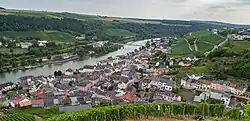 Wormeldange seen from the nearby chapel Koeppchen | |
 Coat of arms | |
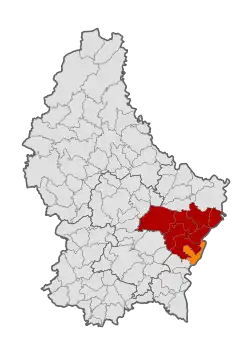 Map of Luxembourg with Wormeldange highlighted in orange, and the canton in dark red | |
| Coordinates: 49°36′40″N 6°24′20″E / 49.6111°N 6.4056°E | |
| Country | |
| Canton | Grevenmacher |
| Government | |
| • Mayor | Claude Pundel (CSV) |
| Area | |
• Total | 17.25 km2 (6.66 sq mi) |
| • Rank | 68th of 100 |
| Highest elevation | 355 m (1,165 ft) |
| • Rank | 82nd of 100 |
| Lowest elevation | 137 m (449 ft) |
| • Rank | 3rd of 100 |
| Population (2025) | |
• Total | 3,255 |
| • Rank | 52nd of 100 |
| • Density | 190/km2 (490/sq mi) |
| • Rank | 46th of 100 |
| Time zone | UTC+1 (CET) |
| • Summer (DST) | UTC+2 (CEST) |
| LAU 2 | LU0001108 |
| Website | wormeldange.lu |
Wormeldange (Luxembourgish: Wuermer [ˈvuːɐ̯mɐ] or locally Wormer; German: Wormeldingen) is a commune and small town in eastern Luxembourg. It is part of the canton of Grevenmacher.
As of 2024, the town of Wormeldange, which lies in the south of the commune, has a population of 995.[2] Other towns within the commune include Ahn, Ehnen, Machtum, and Wormeldange-Haut.
Population
See or edit source data.
Notable people
- Max Hengel (1977-2024), Luxembourgish politician, Mayor of Wormeldange (2017-2020, 2023-2024), Member of the Chamber of Deputies (2022-2024)
References
- ^ "WORMELDANGE - Syvicol". www.syvicol.lu. Retrieved 3 April 2019.
- ^ "Registre national des personnes physiques RNPP : Population par localité". data.public.lu. 2024-01-07.
- ^ "Population par canton et commune". statistiques.public.lu. Retrieved 11 January 2022.
External links
 Media related to Wormeldange at Wikimedia Commons
Places adjacent to Wormeldange | ||||||||||||||||
|---|---|---|---|---|---|---|---|---|---|---|---|---|---|---|---|---|
| ||||||||||||||||