Wilton, North Dakota
Wilton, North Dakota | |
|---|---|
 | |
 Seal | |
| Motto(s): "A city rich in its past and future..." | |
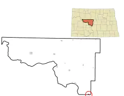 Location of Wilton, North Dakota | |
| Coordinates: 47°09′29″N 100°47′02″W / 47.157997°N 100.783985°W | |
| Country | United States |
| State | North Dakota |
| Counties | McLean, Burleigh |
| Founded | 1899 |
| Government | |
| • Mayor | LeeAnn Domonoske-Kellar |
| Area | |
• Total | 0.568 sq mi (1.471 km2) |
| • Land | 0.556 sq mi (1.440 km2) |
| • Water | 0.012 sq mi (0.031 km2) 2.11% |
| Elevation | 2,172 ft (662 m) |
| Population | |
• Total | 718 |
• Estimate (2024)[4] | 714 |
| • Density | 1,291.37/sq mi (498.47/km2) |
| Time zone | UTC–6 (Central (CST)) |
| • Summer (DST) | UTC–5 (CDT) |
| ZIP Code | 58579 |
| Area code | 701 |
| FIPS code | 38-86580 |
| GNIS feature ID | 1036337[2] |
| Sales tax | 7.0%[5] |
| Website | wiltonnd.org |
Wilton is a city in Burleigh and McLean Counties in North Dakota, United States. It is part of the "Bismarck, ND Metropolitan Statistical Area" or "Bismarck-Mandan". The population was 718 at the 2020 census.[3] Founded in 1899, Wilton was named by General W. D. Washburn after the town of Wilton in his native state of Maine.
History
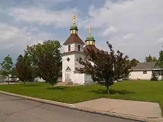
Wilton was platted in 1899 when the railroad was extended to that point.[6] The city was named after Wilton, Maine, the native home of an early settler.[7] The Wilton Train Station was completed in 1900 and the post office has been in operation at Wilton also since 1900.[8] [9] Wilton was originally built up chiefly by Ukrainians.[10]
Geography
According to the United States Census Bureau, the city has a total area of 0.568 square miles (1.47 km2), of which 0.556 square miles (1.44 km2) is land and 0.012 square miles (0.03 km2) (2.11%) is water.[1]
Climate
This climatic region is typified by large seasonal temperature differences, with warm to extremely hot (and often humid) summers and severely cold winters. According to the Köppen Climate Classification system, Wilton has a humid continental climate, abbreviated "Dfb" on climate maps.[11]
Demographics
| Census | Pop. | Note | %± |
|---|---|---|---|
| 1910 | 437 | — | |
| 1920 | 108 | −75.3% | |
| 1930 | 149 | 38.0% | |
| 1940 | 117 | −21.5% | |
| 1950 | 134 | 14.5% | |
| 1960 | 105 | −21.6% | |
| 1970 | 116 | 10.5% | |
| 1980 | 262 | 125.9% | |
| 1990 | 728 | 177.9% | |
| 2000 | 807 | 10.9% | |
| 2010 | 711 | −11.9% | |
| 2020 | 718 | 1.0% | |
| 2024 (est.) | 714 | [4] | −0.6% |
| U.S. Decennial Census[12] 2020 Census[3] | |||


According to realtor website Zillow, the average price of a home as of May 31, 2025, in Wilton is $241,963.[13]
2020 census
As of the 2020 census, there were 718 people, 302 households, and 191 families residing in the city.[14] The population density was 1,291.37 inhabitants per square mile (498.6/km2). There were 339 housing units at an average density of 620.50 per square mile (239.6/km2). The racial makeup of the city was 89.83% White, 0.00% African American, 3.48% Native American, 0.14% Asian, 0.42% Pacific Islander, 0.97% from some other races and 5.15% from two or more races. Hispanic or Latino people of any race were 1.81% of the population.[15]
2010 census
As of the 2010 census, there were 711 people, 317 households, and 188 families residing in the city. The population density was 1,128.6 inhabitants per square mile (435.8/km2). There were 358 housing units at an average density of 568.3 per square mile (219.4/km2). The racial makeup of the city was 96.34% White, 0.00% African American, 2.11% Native American, 0.14% Asian, 0.00% Pacific Islander, 0.56% from some other races and 0.84% from two or more races. Hispanic or Latino people of any race were 1.27% of the population.
There were 317 households, of which 24.3% had children under the age of 18 living with them, 47.6% were married couples living together, 6.3% had a female householder with no husband present, 5.4% had a male householder with no wife present, and 40.7% were non-families. 35.0% of all households were made up of individuals, and 12.3% had someone living alone who was 65 years of age or older. The average household size was 2.17 and the average family size was 2.79.
The median age in the city was 46.7 years. 19.7% of residents were under the age of 18; 7.4% were between the ages of 18 and 24; 20.8% were from 25 to 44; 32.9% were from 45 to 64; and 19.3% were 65 years of age or older. The gender makeup of the city was 53.2% male and 46.8% female.
2000 census
As of the 2000 census, there were 807 people, 309 households, and 219 families residing in the city. The population density was 1,395.3 inhabitants per square mile (538.7/km2). There were 347 housing units at an average density of 599.9 per square mile (231.6/km2). The racial makeup of the city was 98.27% White, 0.12% African American, 0.74% Native American, 0.00% Asian, 0.00% Pacific Islander, 0.00% from some other races and 0.87% from two or more races. Hispanic or Latino people of any race were 0.37% of the population.
There were 309 households, out of which 37.9% had children under the age of 18 living with them, 57.6% were married couples living together, 9.1% had a female householder with no husband present, and 29.1% were non-families. 23.9% of all households were made up of individuals, and 12.6% had someone living alone who was 65 years of age or older. The average household size was 2.57 and the average family size was 3.04.
In the city, the population was spread out, with 28.5% under the age of 18, 6.8% from 18 to 24, 27.5% from 25 to 44, 22.1% from 45 to 64, and 15.1% who were 65 years of age or older. The median age was 37 years. For every 100 females, there were 93.5 males. For every 100 females age 18 and over, there were 93.0 males.
The median income for a household in the city was $34,583, and the median income for a family was $39,063. Males had a median income of $28,750 versus $20,833 for females. The per capita income for the city was $17,111. About 8.0% of families and 10.8% of the population were below the poverty line, including 12.2% of those under age 18 and 17.1% of those age 65 or over.
Education
It is in the Wilton Public School District 1.[16][17]
See also
References
- ^ a b "2024 U.S. Gazetteer Files". United States Census Bureau. Retrieved July 22, 2025.
- ^ a b U.S. Geological Survey Geographic Names Information System: Wilton, North Dakota
- ^ a b c "Explore Census Data". United States Census Bureau. Retrieved October 2, 2023.
- ^ a b "City and Town Population Totals: 2020-2024". United States Census Bureau. Retrieved July 22, 2025.
- ^ "Wilton, North Dakota sales tax rate". Avalara. Retrieved July 22, 2025.
- ^ North Dakota: Counties, Towns & People. Watchmaker Publishing, Ltd. 2008. p. 61. ISBN 978-1-60386-191-5.
- ^ Capace, Nancy (January 1, 2001). Encyclopedia of North Dakota. Somerset Publishers, Inc. p. 303. ISBN 978-0-403-09608-4.
- ^ "National Register of Historic Places Inventory/Nomination: Minneapolis, St. Paul and Sault Sainte Marie Railroad Company Depot / Soo Line Depot". National Park Service. and accompanying photos
- ^ "McLean County". Jim Forte Postal History. Retrieved October 25, 2015.
- ^ Federal Writers' Project (1938). North Dakota, a Guide to the Northern Prairie State. WPA. p. 209. ISBN 978-1-62376-033-5.
{{cite book}}: ISBN / Date incompatibility (help) - ^ Climate Summary for Wilton, North Dakota
- ^ "Decennial Census of Population and Housing". www.census.gov. United States Census Bureau. Retrieved June 4, 2015.
- ^ "Wilton, ND Housing Market". Zillow. Retrieved July 22, 2025.
- ^ "US Census Bureau, Table P16: Household Type". United States Census Bureau. Retrieved July 22, 2025.
- ^ "How many people live in Wilton city, North Dakota". USA Today. Retrieved July 22, 2025.
- ^ "2020 Census - School District Reference Map: Burleigh County, ND" (PDF). United States Census Bureau. Retrieved December 26, 2023.
- ^ "2020 Census - School District Reference Map: McLean County, ND" (PDF). United States Census Bureau. Retrieved December 26, 2023.
External links
Municipalities and communities of Burleigh County, North Dakota, United States | ||
|---|---|---|
| Cities |  | |
| Townships |
| |
| Unorganized territories |
| |
| CDPs | ||
| Other communities | ||
| Ghost town | ||
| Footnotes | ‡This populated place also has portions in an adjacent county or counties | |
Municipalities and communities of McLean County, North Dakota, United States | ||
|---|---|---|
| Cities |  | |
| Townships |
| |
| Unorganized territories |
| |
| CDP | ||
| Other communities | ||
| Indian reservations | ||
| Ghost town | ||
| Footnotes | ‡This populated place also has portions in an adjacent county or counties | |
Bismarck–Mandan Metropolitan Area (ND) | ||
|---|---|---|
| Counties |  | |
| Core cities | ||
| Surrounding areas | ||