Kennet Avenue
| UNESCO World Heritage Site | |
|---|---|
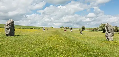 Kennet Avenue in 2014 | |
| Location | Wiltshire, United Kingdom |
| Part of | Avebury Section of Stonehenge, Avebury and Associated Sites |
| Criteria | Cultural: (i), (ii), (iii) |
| Reference | 373bis-002 |
| Inscription | 1986 (10th Session) |
| Extensions | 2008 |
| Coordinates | 51°25′23″N 1°50′53″W / 51.423°N 1.848°W |
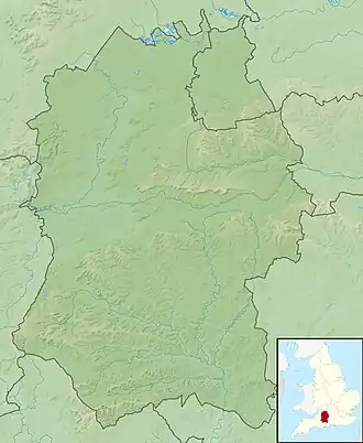 Location of Kennet Avenue in Wiltshire | |
Kennet Avenue or West Kennet Avenue is a prehistoric site in the English county of Wiltshire. It was originally an avenue of two parallel lines of stones 25m wide and 2.5 km in length, which ran between the Neolithic sites of Avebury and The Sanctuary. There are currently 27 upright stones and 37 concrete pillars marking original stone locations.[1]
Excavations directed by Alexander Keiller and Stuart Piggott in 1934 and 1935 indicated that around 100 pairs of standing stones had lined the avenue, dated to around 2200 BC from finds of Beaker burials beneath some of them.[2][1] The missing stones had been pushed over and buried, or broken up for building materials, between the 13th and 17th centuries.[3][4]
A second avenue, called Beckhampton Avenue, led west from Avebury towards Beckhampton Long Barrow, with the 'Adam and Eve' long stones still standing west of the village of Avebury Trusloe.[3]
Archaeological excavations
Wiltshire Archaeological and Natural History Society committee member Maud Cunnington re-erected Stone 33a during her work there in 1911.[4]
Alexander Keiller and Stuart Piggott directed a programme of stone "restoration" on the northern third of the avenue in 1934–1935, beginning at Stone 37a and Stone 37b in the south and finishing where the Avenue joins Avebury stone circle.[2][5]
The avenue is within the Avebury section of the Stonehenge and Avebury World Heritage Site. It is in the freehold ownership of the National Trust, and a scheduled monument in English Heritage guardianship.[6] It is managed by the National Trust on behalf of English Heritage, and the two organisations share the cost of managing and maintaining the property.[7]
Stone naming conventions
Alexander Keiller and Stuart Piggott assigned numbers to stones on the section of West Kennet Avenue that they excavated during 1934 and 1935. What they called numbers 1 and 2 (now 37B and 37A) marked their most southerly point. In their working documents, Keiller and Piggott called the east side of the Avenue the 'left' side, while the west was the 'right' side, which assumes viewing the Avenue facing away from Avebury.[2][8]

Isobel Smith, who was commissioned to write up and consolidate the Keiller-Piggott excavations by Gabrielle Keiller, renumbered the stones across Avebury and West Kennet Avenue. Her system for naming is still in place, starting with Stone 1A closest to Avebury, with paired A and B stones extending out towards the Sanctuary.[2]
Occupation site
The West Kennet Avenue occupation site, discovered by Keiller in 1934 and re-excavated by Joshua Pollard and Mark Gillings in 2013–15, is the remains of Neolithic settlement activity.[9] The more recent excavations recovered 16,399 pieces of worked flint with dating ranging from the Mesolithic to the Early Bronze Age.[10]
Images
-
 'Male' and 'Female' stones in the Avenue
 -
 A megalith showing repairs
References
- ^ a b "History of West Kennet Avenue". English Heritage. Retrieved 12 December 2024.
- ^ a b c d Smith, Isobel (1965). Windmill Hill and Avebury: Excavations by Mr Alexander Keiller 1925–1939. Oxford: Clarendon Press.
- ^ a b Gillings, Mark; Pollard, Joshua; Wheatley, David; Peterson, Rick; Cleal, Rosamund; Cooper, Nicholas; Courtney, Paul; Coward, Fiona; David, Andrew (2008). Landscape of the Megaliths: Excavation and Fieldwork on the Avebury Monuments, 1997–2003. Oxbow Books. ISBN 978-1-84217-971-0.
- ^ a b "Avebury Resource Assessment: part two. Period-based assessments". Stonehenge and Avebury Research Framework. Retrieved 18 August 2025.
- ^ Orbach, Julian; Pevsner, Nikolaus; Cherry, Bridget (2021). Wiltshire. The Buildings Of England. New Haven, US and London: Yale University Press. p. 121. ISBN 978-0-300-25120-3. OCLC 1201298091.
- ^ Historic England. "West Kennet Avenue and an earthwork bank east of West Kennett Farm (1015547)". National Heritage List for England. Retrieved 6 December 2020.
- ^ "West Kennet Avenue, Avebury". English Heritage. Retrieved 6 December 2020.
- ^ Young, William (1934). Leaves from my Journal. Vol. 6. Wiltshire. p. 130.
{{cite book}}: CS1 maint: location missing publisher (link) - ^ Chan, Ben (5 September 2024). "What lies beneath as you walk along the West Kennet Avenue". The Avebury Papers. Archived from the original on 12 December 2024. Retrieved 12 December 2024.
- ^ Chan, Ben (1 September 2024). "Settling the argument: The contribution of use-wear studies to understanding artefact scatters in Neolithic Britain". Journal of Archaeological Science: Reports. 57: 104686. doi:10.1016/j.jasrep.2024.104686. ISSN 2352-409X.
External links
![]() Media related to West Kennet Avenue at Wikimedia Commons
Media related to West Kennet Avenue at Wikimedia Commons