Villaviciosa, Abra
Villaviciosa | |
|---|---|
| Municipality of Villaviciosa | |
 Flag | |
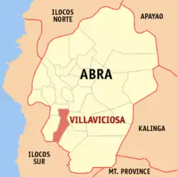 Map of Abra with Villaviciosa highlighted | |
OpenStreetMap | |
.svg.png) Villaviciosa Location within the Philippines | |
| Coordinates: 17°26′N 120°38′E / 17.44°N 120.63°E | |
| Country | Philippines |
| Region | Cordillera Administrative Region |
| Province | Abra |
| District | Lone district |
| Barangays | 8 (see Barangays) |
| Government | |
| • Type | Sangguniang Bayan |
| • Mayor | Jose W. Lagen Jr. |
| • Vice Mayor | Marjorie L. Lagen |
| • Representative | Menchie B. Bernos |
| • Municipal Council | Members |
| • Electorate | 4,302 voters (2025) |
| Area | |
• Total | 102.93 km2 (39.74 sq mi) |
| Elevation | 325 m (1,066 ft) |
| Highest elevation | 667 m (2,188 ft) |
| Lowest elevation | 126 m (413 ft) |
| Population (2024 census)[3] | |
• Total | 5,674 |
| • Density | 55/km2 (140/sq mi) |
| • Households | 1,367 |
| Economy | |
| • Income class | 5th municipal income class |
| • Poverty incidence | 19.1 |
| • Revenue | ₱ 547.3 million (2022) |
| • Assets | ₱ 1,028 million (2022) |
| • Expenditure | ₱ 422.3 million (2022) |
| • Liabilities | ₱ 35.95 million (2022) |
| Service provider | |
| • Electricity | Abra Electric Cooperative (ABRECO) |
| Time zone | UTC+8 (PST) |
| ZIP code | 2811 |
| PSGC | |
| IDD : area code | +63 (0)74 |
| Native languages | Itneg Atta Ilocano Tagalog |
Villaviciosa, officially the Municipality of Villaviciosa (Ilocano: Ili ti Villaviciosa; Maeng Itneg: Ili di Villaviciosa; Tagalog: Bayan ng Villaviciosa), is a municipality in the province of Abra, Philippines. According to the 2020 census, it has a population of 5,675 people.[5]
The town is known for the Kimkimay Lake, a reminder of the wrath of the gods against people who have numerous vices.[6]
History
During the Spanish era, Villaviciosa was once called 'Kalaw', which was derived from its first settler, 'Agcalaw', who was from Ananaaw (now Gregorio del Pilar, Ilocos Sur).[7]
In 1904, Villaviciosa was separated from the town of Pilar, and eventually became a municipality in 1917. During World War II, on 8 December 1941, the people of Villaviciosa evacuated from the town towards the hinterlands. Sometime in December 1942, Japanese forces arrived in the town and ordered everyone to return to their homes. However guerrilla activity remained prevalent. By 1944, almost all men had joined the resistance against the Japanese. In one incident, Japanese forces were ambushed at a bridge near the south of the town, which then led to harsh Japanese reprisals against the innocent civilians.[7]
Geography
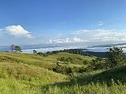
According to the Philippine Statistics Authority, the municipality has a land area of 102.93 square kilometres (39.74 sq mi) [8] constituting 2.47% of the 4,165.25-square-kilometre- (1,608.21 sq mi) total area of Abra. Villaviciosa is located at 17°26′N 120°38′E / 17.44°N 120.63°E.
The municipality is geographically situated at the southern portion of Abra, bounded in the north-west by San Isidro, north by Bucay, east by Manabo and Luba, south by San Emilio, and west by Pilar.
The town is accessible from Benguet by land transportation through the Abra-Ilocos Sur Road, the more frequently used route. From the nearby Province of Ilocos Sur, it is also accessible through the Candon via San Emilio to Luba‑Tamac, Villaviciosa Road and the Santa Maria‑Burgos via Pilar‑Villaviciosa Road.
Villavicios is situated 22.42 kilometres (13.93 mi) from the provincial capital Bangued, and 428.27 kilometres (266.11 mi) from the country's capital city of Manila.
Climate
| Climate data for Villaviciosa, Abra | |||||||||||||
|---|---|---|---|---|---|---|---|---|---|---|---|---|---|
| Month | Jan | Feb | Mar | Apr | May | Jun | Jul | Aug | Sep | Oct | Nov | Dec | Year |
| Mean daily maximum °C (°F) | 29 (84) |
30 (86) |
31 (88) |
33 (91) |
31 (88) |
30 (86) |
29 (84) |
29 (84) |
29 (84) |
30 (86) |
30 (86) |
29 (84) |
30 (86) |
| Mean daily minimum °C (°F) | 18 (64) |
18 (64) |
20 (68) |
22 (72) |
24 (75) |
24 (75) |
23 (73) |
23 (73) |
23 (73) |
21 (70) |
20 (68) |
18 (64) |
21 (70) |
| Average precipitation mm (inches) | 10 (0.4) |
10 (0.4) |
14 (0.6) |
23 (0.9) |
80 (3.1) |
103 (4.1) |
121 (4.8) |
111 (4.4) |
119 (4.7) |
114 (4.5) |
39 (1.5) |
15 (0.6) |
759 (30) |
| Average rainy days | 5.2 | 3.9 | 6.2 | 9.1 | 18.5 | 21.4 | 22.9 | 19.8 | 19.8 | 16.2 | 10.5 | 6.1 | 159.6 |
| Source: Meteoblue[9] | |||||||||||||
Barangays
Villaviciosa is politically subdivided into 8 barangays.[10] Each barangay consists of puroks and some have sitios.
| PSGC | Barangay | Population | ±% p.a. | |||
|---|---|---|---|---|---|---|
| 2024[11] | 2010[12] | |||||
| 140127001 | Ap-apaya | 9.6% | 542 | 531 | 0.14% | |
| 140127002 | Bol-lilising | 5.0% | 283 | 294 | −0.27% | |
| 140127003 | Cal-lao | 16.6% | 940 | 931 | 0.07% | |
| 140127004 | Lap-lapog | 16.1% | 916 | 766 | 1.26% | |
| 140127005 | Lumaba | 9.8% | 558 | 552 | 0.08% | |
| 140127006 | Poblacion | 15.8% | 897 | 836 | 0.49% | |
| 140127007 | Tamac | 11.9% | 678 | 627 | 0.55% | |
| 140127008 | Tuquib | 15.2% | 861 | 840 | 0.17% | |
| Total | 5,674 | 5,675 | 0.00% | |||
Demographics
| Year | Pop. | ±% p.a. |
|---|---|---|
| 1918 | 1,621 | — |
| 1939 | 2,574 | +2.23% |
| 1948 | 2,474 | −0.44% |
| 1960 | 3,194 | +2.15% |
| 1970 | 4,006 | +2.29% |
| 1975 | 3,865 | −0.72% |
| 1980 | 3,933 | +0.35% |
| 1990 | 4,612 | +1.61% |
| 1995 | 4,634 | +0.09% |
| 2000 | 4,877 | +1.10% |
| 2007 | 5,147 | +0.75% |
| 2010 | 5,377 | +1.60% |
| 2015 | 5,392 | +0.05% |
| 2020 | 5,675 | +1.08% |
| 2024 | 5,674 | −0.00% |
| Source: Philippine Statistics Authority[13][14][12][15][16] | ||
In the 2020 census, Villaviciosa had a population of 5,675.[17] The population density was 55 inhabitants per square kilometre (140/sq mi).
Economy
Poverty incidence of Villaviciosa
10
20
30
40
50
60
2000
45.79 2003
54.79 2006
49.70 2009
49.07 2012
39.16 2015
14.26 2018
19.93 2021
19.10 Source: Philippine Statistics Authority[18][19][20][21][22][23][24][25] |
Government
Local government
Villaviciosa, belonging to the lone congressional district of the province of Abra, is governed by a mayor designated as its local chief executive and by a municipal council as its legislative body in accordance with the Local Government Code. The mayor, vice mayor, and the councilors are elected directly by the people through an election which is being held every three years.
Elected officials
| Position | Name |
|---|---|
| Congressman | Joseph Santo Niño B. Bernos |
| Mayor | Jose W. Lagen Jr. |
| Vice-Mayor | Marjorie L. Lagen |
| Councilors | Nelson L. Piyo |
| Edmundo B. Belmes | |
| Nixon B. Belmes | |
| Amelito M. Bagno | |
| Ingrid B. Oca | |
| Ernest G. Binnong | |
| Elsie L. Bona | |
| Tessie G. Paned |
Education
The Villaviciosa Schools District Office governs all educational institutions within the municipality. It oversees the management and operations of all private and public, from primary to secondary schools.[27]
Primary and elementary schools
- Bol-lilising Elementary School
- Cal-lao Elementary School
- Lagaosian Elementary School
- Tamac Elementary School
- Villaviciosa Central School
Secondary schools
- Lumaba Integrated School
- Tuquib Integrated School
References
- ^ Municipality of Villaviciosa | (DILG)
- ^ "2015 Census of Population, Report No. 3 – Population, Land Area, and Population Density" (PDF). Philippine Statistics Authority. Quezon City, Philippines. August 2016. ISSN 0117-1453. Archived (PDF) from the original on May 25, 2021. Retrieved July 16, 2021.
- ^ "2024 Census of Population (POPCEN) Population Counts Declared Official by the President". Philippine Statistics Authority. 17 July 2025. Retrieved 18 July 2025.
- ^ "PSA Releases the 2021 City and Municipal Level Poverty Estimates". Philippine Statistics Authority. 2 April 2024. Retrieved 28 April 2024.
- ^ "2024 Census of Population (POPCEN) Population Counts Declared Official by the President". Philippine Statistics Authority. 17 July 2025. Retrieved 18 July 2025.
- ^ "Kimkimay Lake in Villaviciosa, Abra, Philippines". Archived from the original on 2018-01-21.
- ^ a b "NLP Digital Collection HD01.p1.m20.md1". nlpdl.nlp.gov.ph. Retrieved 2025-07-07.
- ^ "Province:". PSGC Interactive. Quezon City, Philippines: Philippine Statistics Authority. Retrieved 12 November 2016.
- ^ "Villaviciosa: Average Temperatures and Rainfall". Meteoblue. Retrieved 26 April 2020.
- ^ "Municipal: Villaviciosa, Abra". PSGC Interactive. Quezon City, Philippines: Philippine Statistics Authority. Retrieved 8 January 2016.
- ^ Census of Population (2020). "Cordillera Administrative Region (CAR)". Total Population by Province, City, Municipality and Barangay. Philippine Statistics Authority. Retrieved 8 July 2021.
- ^ a b Census of Population and Housing (2010). "Cordillera Administrative Region (CAR)" (PDF). Total Population by Province, City, Municipality and Barangay. National Statistics Office. Retrieved 29 June 2016.
- ^ "2024 Census of Population (POPCEN) Population Counts Declared Official by the President". Philippine Statistics Authority. 17 July 2025. Retrieved 18 July 2025.
- ^ Census of Population (2015). "Cordillera Administrative Region (CAR)". Total Population by Province, City, Municipality and Barangay. Philippine Statistics Authority. Retrieved 20 June 2016.
- ^ Censuses of Population (1903–2007). "Cordillera Administrative Region (CAR)". Table 1. Population Enumerated in Various Censuses by Province/Highly Urbanized City: 1903 to 2007. National Statistics Office.
- ^ "Province of". Municipality Population Data. Local Water Utilities Administration Research Division. Retrieved 17 December 2016.
- ^ "2024 Census of Population (POPCEN) Population Counts Declared Official by the President". Philippine Statistics Authority. 17 July 2025. Retrieved 18 July 2025.
- ^ "Poverty incidence (PI):". Philippine Statistics Authority. Retrieved December 28, 2020.
- ^ "Estimation of Local Poverty in the Philippines" (PDF). Philippine Statistics Authority. 29 November 2005.
- ^ "2003 City and Municipal Level Poverty Estimates" (PDF). Philippine Statistics Authority. 23 March 2009.
- ^ "City and Municipal Level Poverty Estimates; 2006 and 2009" (PDF). Philippine Statistics Authority. 3 August 2012.
- ^ "2012 Municipal and City Level Poverty Estimates" (PDF). Philippine Statistics Authority. 31 May 2016.
- ^ "Municipal and City Level Small Area Poverty Estimates; 2009, 2012 and 2015". Philippine Statistics Authority. 10 July 2019.
- ^ "PSA Releases the 2018 Municipal and City Level Poverty Estimates". Philippine Statistics Authority. 15 December 2021. Retrieved 22 January 2022.
- ^ "PSA Releases the 2021 City and Municipal Level Poverty Estimates". Philippine Statistics Authority. 2 April 2024. Retrieved 28 April 2024.
- ^ "2019 National and Local Elections" (PDF). Commission on Elections. Retrieved March 12, 2022.
- ^ "Masterlist of Schools" (PDF). Department of Education. January 15, 2021. Retrieved May 8, 2025.
External links
- Philippine Standard Geographic Code
- Municipality of Villaviciosa Archived 2005-12-16 at the Wayback Machine
Places adjacent to Villaviciosa, Abra | ||||||||||||||||
|---|---|---|---|---|---|---|---|---|---|---|---|---|---|---|---|---|
| ||||||||||||||||
Bangued (capital and largest municipality) | |
| Municipalities | |
| Barangays | |