Vallard Atlas
The Vallard Atlas is one of the most renowned atlases of the 16th century. It is an example of the Dieppe school of cartography, produced in Dieppe, France, in 1547. On the front page is the inscription "Nicolas Vallard de Dieppe, 1547"; he is believed to be the first owner[1] and probably not the person who created the atlas.[2] It is believed that the Vallard Atlas was developed either by a Portuguese cartographer or from an earlier Portuguese prototype.[2] Since 1924, the original atlas has been held by the Huntington Library in San Marino, California, United States.
Description
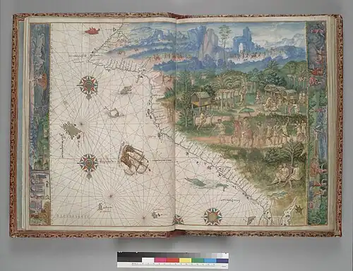
The atlas consists of 68 pages, which include a calendar and 15 nautical charts with illustrations, as well as detailed maritime information. It contains illustrations of the indigenous population of the New World.
The original atlas was bound in red leather with gold decorations in 1805.
An unusual feature of the work lies in the fact that the map reverses the common orientation of the world, with the south at the top and the north at the bottom.[3]
Speculation of the Portuguese discovery of Australia
There is some speculation that, like some other works of the Dieppe school of maps, the atlas may show the Australian coastline with its depiction of a continent labelled Jave la Grande, which would mean it preceded the documented discoveries by Willem Janszoon or James Cook.[3][4][5][6] However, most historians do not accept this theory, and the interpretation of this feature of the Vallard and other Dieppe maps is highly contentious.[7][8][9][10][11]
References
- ^ Lapouge, Gilles (2012). "L'énigme de l'atlas dieppois". Geohistoire (2): 104–111.
- ^ a b "Guide To Medieval and Renaissance Manuscripts in the Huntington Library: HM 29 "Vallard Atlas"". Bancroft.berkeley.edu. Archived from the original on 28 September 2012. Retrieved 4 September 2015.
- ^ a b Thomaz, Luís Filipe F.R.; Reinhartz, D.; García-Tejedor, C.M. (2010). Atlas Vallard, Libro de estudio. M. Moleiro. ISBN 978-84-96400-47-4.
- ^ K.G. McIntyre (1977), The Secret Discovery of Australia; Portuguese discoveries 200 years before Captain Cook. (Souvenir Press, Medindie, South Australia. ISBN 0-285-62303-6)
- ^ Trickett, P. (2007), Beyond Capricorn: How Portuguese adventurers discovered and mapped Australia and New Zealand 250 years before Captain Cook. (East St. Publications. Adelaide. ISBN 978-0-9751145-9-9)
- ^ Josef Brinke, "The Oldest Map Reproduction of Australia", Geografie, 65(1), 2024, pp.29-40.
- ^ Richardson, William Arthur Ridley (1989). The Portuguese Discovery of Australia, Fact or Fiction?. Canberra: National Library of Australia. p. 6. ISBN 0642104816. Retrieved 2 March 2016.
- ^ "A voyage of rediscovery about a voyage of rediscovery". The Guardian. London. 26 March 2007. Retrieved 25 February 2016.
- ^ Gayle K. Brunelle, "Dieppe School", in David Buisseret (ed.), The Oxford Companion to World Exploration, New York, Oxford University Press, 2007, pp.237–238.
- ^ Robert J. King, "The Jagiellonian Globe, a Key to the Puzzle of Jave la Grande", The Globe: Journal of the Australian Map Circle, No. 62, 2009, pp. 1–50.
- ^ Robert J. King, "Regio Patalis: Australia on the map in 1531?", The Portolan, Issue 82, Winter 2011, pp. 8–17.
External links
- The Huntington Library.
- Veröffentlichtes Bild in der Tageszeitung El Mundo 15. Oktober 2015.
- Faksimileausgabe 2008 veröffentlicht von dem Verlag M.Moleiro.