Khirbet al-Halawa
Khirbat al-Khalawa
خربة الحلاوة | |
|---|---|
Village / hamlet | |
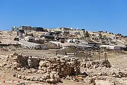 General view of Khirbat al-Halawa, 2025 | |
| State | State of Palestine |
| Governorate | Hebron Governorate |
| Area | Masafer Yatta |
| Population | |
• Total | ~120–250 (2,022–2,025 est.) |
| Time zone | UTC+2 (UTC+3 DST) |
Khirbet al-Halawa or al-Halawi (Arabic: خربة الحلاوة) is a small Palestinian hamlet located in the Masafer Yatta area of the Hebron Governorate, in the southern West Bank. Like other hamlets in Masafer Yatta, it is administered under Palestinian local frameworks but lies within Area C of the West Bank, under direct Israeli civil and military occupation. Residents face ongoing threats of demolition, restricted access to infrastructure, and settler-related attacks.[1]
History and archaeology
The name Khirbat al-Halawa (lit. "ruin of sweet candy") is remembered locally as referring to a prominent local landmark. The Masafer Yatta region takes its name from the Arabic words for “travelling,” reflecting its history as a seasonal grazing and migration area for semi-nomadic herders.[2]
Oral traditions trace the permanent settlement of Kh. al-Halawa to families from Yatta in the early 20th century, who adapted existing caves and stone structures for habitation. In the British Mandate period, residents relied on a combination of animal husbandry, dryland farming, and seasonal grazing.
Legal-administrative context
Residents of Khirbet al-Halawa continue to inhabit caves, a legacy of displacement and military restrictions, despite possessing family land titles dating back generations. They describe being prevented from constructing homes or accessing basic services such as water, electricity, schools or roads, despite long-standing agricultural use, under the pretext of residing in a “military zone.””[3] Indeed, since the 1970s, Khirbet al-Halawa has been included in Israel’s declared Firing Zone 918, a closed military zone covering much of Masafer Yatta.[4] In May 2022, the Israeli Supreme Court upheld eviction orders for eight hamlets within the zone, placing over 2,000 residents, including those of Khirbet al-Halawa, at risk of forcible transfer.[5]
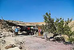
The village’s stone houses, tents, and cisterns have been repeatedly subjected to demolition orders. Residents depend heavily on rainwater collection and solar power due to restrictions on infrastructure connection.[6] Human rights groups have described the policy environment as amounting to ethnic cleansing.[7][8][9]
On 2 May 2018, the Israeli troops demolished several residential and agricultural structures in Khirbet al-Halawa within Masafer Yatta, further contributing to the dispossession and displacement of its inhabitants.[10] On 17 June 2019, Israeli forces demolished two additional residential structures in Khirbet al-Halawa, further exacerbating the precarious living conditions of its inhabitants, already threatened by demolition orders and eviction procedures.[11]
On 30 April 2025, Israeli colonizers released their livestock to graze on Palestinian agricultural land in the Halawa area of Masafer Yatta—specifically targeting olive and almond groves owned by Palestinian farmer Ahmad Ismail Abu Arram—causing damage to planted crops and undermining local livelihoods.[12]
Population and livelihoods
Khirbet al-Halawa’s population is estimated between 120 and 250 residents in recent years. Inhabitants are Arabic-speaking and primarily engaged in goat herding, cultivation of olives, and seasonal field crops. As in other parts of Masafer Yatta, water is supplied mostly by tanker, while electricity is provided through solar panels maintained by local and NGO initiatives.[13]
See also
External links
References
- ^ "Jinba Background – Living Archive". living-archive.org. Retrieved 2025-07-07.
- ^ At Tuwani & Mosfaret Yatta Profile. Applied Research Institute-Jerusalem (ARIJ). 2009.
- ^ ""Earth's pockets"… resilient Palestinian villages living in mountain caves". Al Jazeera Documentary. 2023-11-28. Retrieved 2025-08-11.
- ^ https://www.haaretz.com/israel-news/2013-07-05/ty-article/.premium/tiny-wb-village-to-be-huge-army-training-zone/0000017f-db6c-d856-a37f-ffecdb870000
- ^ Reiff, Ben (2022-05-12). "Armed with High Court expulsion order, Israel's bulldozers arrive in Masafer Yatta". +972 Magazine. Retrieved 2025-07-06.
- ^ abukhdeir, thawra (2022-10-01). "Evacuation of Villagers in the Masafer Yatta Area of the South Hebron Hills | Association for Civil Rights in Israel". ACRI - english. Retrieved 2025-07-06.
- ^ ""Israel is Implementing Practices of Ethnic Cleansing of Palestinians" | Faces of the Occupation | Looking the Occupation in the Eye". www.mistaclim.org. Retrieved 2025-06-14.
- ^ "Ethnic cleansing in Masafer Yatta: a focus on Susiya". Home. 2025-04-03. Retrieved 2025-06-14.
- ^ "Breaking the Silence › Testimony › The village was turned upside down". Breaking the Silence. Retrieved 2025-06-14.
- ^ "Occupation demolishes residential and agricultural structures in the village of al-Halawi, Masafer Yatta, Hebron Governorate". Land Research Center. 2018-05-02. Retrieved 2025-08-11.
- ^ "Two houses demolished in Al-Halawah – Masafer Yatta / Hebron governorate". Land Research Center. 2019-06-17. Retrieved 2025-08-11.
- ^ "Israeli colonizers release livestock to destroy Palestinian crops in Hebron". IMEMC News. 2025-04-30. Retrieved 2025-08-11.
- ^ McKernan, Bethan (2022-05-12). "Israel approves 2,700 housing units in illegal West Bank settlements". The Guardian. ISSN 0261-3077. Retrieved 2025-07-06.
31°23′N 35°08′E / 31.38°N 35.13°E Israeli occupation of the West Bank