Toi San (Macao)
Toi San
台山 | |
|---|---|
Freguesia (parish) | |
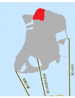 Location of Toi San on the Macau Peninsula | |
| Country | |
| Region | Macau Peninsula |
| District | Nossa Senhora de Fátima |
| Area | |
• Total | 0.33 km2 (0.13 sq mi) |
| Population (2021) | |
• Total | 31,000 |
| • Density | 94,000/km2 (240,000/sq mi) |
| Time zone | UTC+8 (Macau Standard Time) |
| Area code | +853 |
| ISO 3166 code | MO |
Toi San (Chinese: 台山) is a densely populated urban district located in the northern part of the Macau Peninsula, within the parish of Nossa Senhora de Fátima. It is one of the key residential and commercial neighborhoods in Macau, known for its proximity to the Border Gate and the adjacent Areia Preta and San Kio areas.[1]
The area features a mix of high-rise residential buildings, traditional markets, schools, and healthcare facilities. It is served by major roads such as Avenida de Venceslau de Morais and Estrada do Arco. Due to its location near the northern boundary of Macau, Toi San is an important transit corridor connecting central Macau to the Zhuhai city of mainland China.
Toi San has undergone extensive urban redevelopment since the late 20th century, transitioning from a working-class neighborhood to a more modernized urban environment, while still retaining elements of its traditional community life.[2]
History
Toi San was originally part of a coastal marshland area in northern Macao. During the early 20th century, the region underwent a series of land reclamation projects, particularly between 1919 and 1924, to support urban expansion and industrial development. The reclaimed land laid the foundation for what would become one of the peninsula’s most densely built residential neighborhoods.[3]
In 1925, Toi San was the site of a catastrophic fireworks factory explosion, which resulted in significant casualties and prompted changes to safety regulations concerning pyrotechnic production in Macao. The area later transitioned into a primarily residential district, with many apartment buildings constructed in the post-war decades, especially during the 1970s and 1980s.[4]
Today, Toi San reflects a mix of historic structures, older tenement housing, and high-density redevelopment, representing both the challenges and resilience of urban transformation in Macao's northern peninsula.
References
- ^ "Cartography and Cadastre Bureau". www.dscc.gov.mo. Retrieved 2025-07-24.
- ^ "文章内容". www.macaudata.mo. Retrieved 2025-07-24.
- ^ "台山". www.macaumemory.mo. Retrieved 2025-07-24.
- ^ "Macao Museum remembers pivotal industries". macaomagazine.net. 2018-01-14. Retrieved 2025-07-24.