Tohmajärvi
Tohmajärvi | |
|---|---|
Municipality | |
| Tohmajärven kunta Tohmajärvi kommun | |
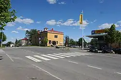 Kemie, the central village of Tohmajärvi. | |
 Coat of arms | |
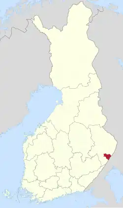 Location of Tohmajärvi in Finland | |
| Coordinates: 62°14′N 30°20′E / 62.233°N 30.333°E | |
| Country | |
| Region | North Karelia |
| Sub-region | Central Karelia |
| Charter | 1869 |
| Seat | Kemie |
| Government | |
| • Municipal manager | Olli Riikonen |
| Area (2018-01-01)[1] | |
• Total | 895.36 km2 (345.70 sq mi) |
| • Land | 837.82 km2 (323.48 sq mi) |
| • Water | 57.62 km2 (22.25 sq mi) |
| • Rank | 93rd largest in Finland |
| Population (2025-06-30)[2] | |
• Total | 3,925 |
| • Rank | 195th largest in Finland |
| • Density | 4.68/km2 (12.1/sq mi) |
| Population by native language | |
| • Finnish | 93.4% (official) |
| • Swedish | 0.3% |
| • Others | 6.3% |
| Population by age | |
| • 0 to 14 | 12.8% |
| • 15 to 64 | 53.8% |
| • 65 or older | 33.4% |
| Time zone | UTC+02:00 (EET) |
| • Summer (DST) | UTC+03:00 (EEST) |
| Website | www |
Tohmajärvi (Finnish pronunciation: [ˈtohmɑˌjærʋi]) is a municipality of Finland. It is located in the North Karelia region. The municipality has a population of 3,925 (30 June 2025)[6] and covers an area of 895.36 square kilometres (345.70 sq mi) of which 57.62 km2 (22.25 sq mi) is water.[1] The population density is 4.68 inhabitants per square kilometre (12.1/sq mi). The municipality is unilingually Finnish.
Neighbouring municipalities are Joensuu, Kitee and Rääkkylä. The municipality of Värtsilä was consolidated with Tohmajärvi in 2005. Sortavala, a town in the Karelia, Russia, is located 81 kilometres (50 mi) south of Tohmajärvi.
Tohmajärvi is located along the Blue Highway, which is an international tourist route from Mo i Rana, Norway to Pudozh, Russia via Sweden. The border crossing to Russia, Niirala, is in Värtsilä, now part of Tohmajärvi.
One of the most significant highways in Tohmajärvi is Highway 9, which runs west through Joensuu, Kuopio, Jyväskylä and Tampere to Turku. The Blue Highway follows this highway to Tohmajärvi.
Climate
Tohmajärvi has a subarctic climate (Köppen: Dfc).
| Climate data for Tohmajärvi Kemie (1991-2020 normals, extremes 1959-present) | |||||||||||||
|---|---|---|---|---|---|---|---|---|---|---|---|---|---|
| Month | Jan | Feb | Mar | Apr | May | Jun | Jul | Aug | Sep | Oct | Nov | Dec | Year |
| Record high °C (°F) | 5.9 (42.6) |
7.4 (45.3) |
13.1 (55.6) |
24.7 (76.5) |
29.6 (85.3) |
32.3 (90.1) |
35.4 (95.7) |
31.8 (89.2) |
26.9 (80.4) |
18.9 (66.0) |
11.3 (52.3) |
8.6 (47.5) |
35.4 (95.7) |
| Mean maximum °C (°F) | 2.5 (36.5) |
2.4 (36.3) |
7.8 (46.0) |
16.2 (61.2) |
24.1 (75.4) |
26.8 (80.2) |
28.1 (82.6) |
26.2 (79.2) |
20.6 (69.1) |
12.8 (55.0) |
7.0 (44.6) |
3.3 (37.9) |
29.1 (84.4) |
| Mean daily maximum °C (°F) | −5.5 (22.1) |
−4.9 (23.2) |
0.6 (33.1) |
7.2 (45.0) |
14.8 (58.6) |
19.4 (66.9) |
22.1 (71.8) |
19.8 (67.6) |
13.8 (56.8) |
6.2 (43.2) |
0.5 (32.9) |
−2.9 (26.8) |
7.6 (45.7) |
| Daily mean °C (°F) | −8.6 (16.5) |
−8.8 (16.2) |
−4.0 (24.8) |
2.2 (36.0) |
8.9 (48.0) |
13.9 (57.0) |
16.6 (61.9) |
14.3 (57.7) |
9.3 (48.7) |
3.4 (38.1) |
−1.7 (28.9) |
−5.5 (22.1) |
3.3 (38.0) |
| Mean daily minimum °C (°F) | −12.2 (10.0) |
−12.8 (9.0) |
−8.8 (16.2) |
−2.9 (26.8) |
2.4 (36.3) |
7.6 (45.7) |
10.7 (51.3) |
9.0 (48.2) |
5.0 (41.0) |
0.5 (32.9) |
−4.2 (24.4) |
−8.7 (16.3) |
−1.2 (29.8) |
| Mean minimum °C (°F) | −29.3 (−20.7) |
−28.9 (−20.0) |
−22.8 (−9.0) |
−12.8 (9.0) |
−5.2 (22.6) |
−0.2 (31.6) |
3.8 (38.8) |
1.1 (34.0) |
−3.2 (26.2) |
−9.8 (14.4) |
−16.1 (3.0) |
−23.7 (−10.7) |
−32.5 (−26.5) |
| Record low °C (°F) | −42.4 (−44.3) |
−39.4 (−38.9) |
−37.0 (−34.6) |
−28.8 (−19.8) |
−13.6 (7.5) |
−4.1 (24.6) |
−0.4 (31.3) |
−4.1 (24.6) |
−9.0 (15.8) |
−20.1 (−4.2) |
−29.3 (−20.7) |
−37.3 (−35.1) |
−42.4 (−44.3) |
| Average precipitation mm (inches) | 53 (2.1) |
43 (1.7) |
39 (1.5) |
31 (1.2) |
44 (1.7) |
70 (2.8) |
80 (3.1) |
87 (3.4) |
67 (2.6) |
71 (2.8) |
60 (2.4) |
62 (2.4) |
707 (27.7) |
| Average precipitation days (≥ 1.0 mm) | 12 | 10 | 9 | 7 | 9 | 11 | 11 | 11 | 11 | 13 | 13 | 13 | 130 |
| Source 1: FMI normals 1991-2020[7] | |||||||||||||
| Source 2: Record highs and lows 1959- present[8] | |||||||||||||
Notable people
- Anna Easteden, actress and model
- Katri Helena, singer
- Siiri Rantanen, skier
- Seppo Räty, javelin thrower
- Algot Untola, author and journalist
See also
References
- ^ a b "Area of Finnish Municipalities 1.1.2018" (PDF). National Land Survey of Finland. Retrieved 30 January 2018.
- ^ "Population increased most in Uusimaa in January to June 2025". Population structure. Statistics Finland. 2025-07-24. ISSN 1797-5395. Retrieved 2025-07-24.
- ^ "Number of foreign-language speakers exceeded 600,000 during 2024". Population structure. Statistics Finland. 2025-04-04. ISSN 1797-5395. Retrieved 2025-04-05.
- ^ "Population according to age (1-year) and sex by area and the regional division of each statistical reference year, 2003–2020". StatFin. Statistics Finland. Retrieved 2 May 2021.
- ^ a b "Luettelo kuntien ja seurakuntien tuloveroprosenteista vuonna 2023". Tax Administration of Finland. 14 November 2022. Retrieved 7 May 2023.
- ^ "VÄESTÖTIETOJÄRJESTELMÄ REKISTERITILANNE 31.1.2012" (in Finnish and Swedish). Population Register Center of Finland. Archived from the original on 3 October 2013. Retrieved 11 February 2014.
- ^ "FMI normals 1991-2020". FMI. Retrieved 14 July 2025.
- ^ "FMI open data". FMI. Retrieved 14 July 2025.
External links
![]() Media related to Tohmajärvi at Wikimedia Commons
Media related to Tohmajärvi at Wikimedia Commons
![]() Tohmajärvi travel guide from Wikivoyage
Tohmajärvi travel guide from Wikivoyage
- Municipality of Tohmajärvi – Official website
Places adjacent to Tohmajärvi | ||||||||||||||||
|---|---|---|---|---|---|---|---|---|---|---|---|---|---|---|---|---|
| ||||||||||||||||
| Municipalities |  | |
|---|---|---|
| Former municipalities |
| |