Timok Valley
.jpg)
The Timok Valley (Serbian: Тимочка Крајина, romanized: Timočka Krajina; Bulgarian: Тимошко, romanized: Timoshko; Romanian: Valea Timocului) is a geographical region in eastern Serbia around the Timok River. It has a total population of 197,815 and roughly corresponds to two administrative districts, Bor and Zaječar.[1]
Name
The Serbian name is derived from the hydronym Timok and krajina ("frontier, march"), named such due to its location and history as a borderland. It was introduced in the interwar period as denoting the Timok confluence with the Negotin Valley and Ključ, which are part of the Timok Valley.[2] The term has no historical or geographical basis.[2] In Romanian, the term "Timoc Valley" (Valea Timocului) is used for the area inhabited by the Romanian-speaking Vlachs.[3] "Tribalia" is also used in Romanian.[4] The region was sometimes known as Podunavia in medieval times.[5]
History
Early Bronze Age pottery of the Kostolac-Kocofeni culture has been found throughout the region.[6] During the Roman era, the area was administratively part of the Dacia Ripensis. During emperor Justinian's reign there were numerous fortifications in the area. Notable Roman sites include Timacum Minus, Trajan's Bridge, Diana Fortress, and others. The Bulgarian ruler Ivan Stratsimir (Vidin Principate) and Wallachian Voivode Mircea the Elder controlled the territory of Podunavia (the Timok Valley) until the Ottoman conquest in the 14th century.[5] Several settlements in the region received Habsburg monarchy frontier status after the 1718 Treaty of Passarowitz; the area became a frontier towards the Ottoman Empire.[7]
A peasant uprising took place in 1883, known as the Timok Rebellion, resulting from various economic, political, and social factors.
Between 1918 and 1922, there were two districts of the Kingdom of Serbs, Croats, and Slovenes in the area – Krajina District, with seat in Negotin, and Timok District with seat in Zaječar. In 1922, these two districts were merged into the newly formed Timok Oblast with seat in Zaječar. Timok Oblast existed until 1929 when it was included into the newly formed Morava Banovina with seat in Niš. At present there are two administrative districts encompassing the area: Bor District with seat in Bor; and Zaječar District with seat in Zaječar.
Demographics
Towns
There are three towns with over 10,000 inhabitants.
Ethnic structure
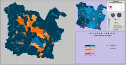
The region is inhabited by a majority of Serbs and minority of Vlachs. The Serb community traditionally speak the Kosovo–Resava dialect in the north and the Prizren-Timok dialect in the south; however, standard Serbian is used in formal communication. The Vlachs speak a variety of two dialects (Banat and Oltenian dialects) of the Romanian language, which awaits standardization into a hypothetical new language for the Vlachs.[8] Both Serbs and Vlachs are Eastern Orthodox by denomination. There is ongoing debate over the ethnic identification of the Vlach community and whether they are Romanians or not.
| Ethnicity | Population[9] | Share |
|---|---|---|
| Serbs | 162,414 | 82.1% |
| Vlachs | 11,336 | 5.7% |
| Roma | 3,521 | 1.7% |
| Others | 5,736 | 2.9% |
| Undeclared/Unknown | 16,548 | 8.3% |
Geography
Climate
Zaječar, the biggest town in the region, has a humid continental climate (Köppen climate classification: Dfa), bordering on a humid subtropical climate (Köppen climate classification: Cfa).
| Climate data for Zaječar (1981–2010) | |||||||||||||
|---|---|---|---|---|---|---|---|---|---|---|---|---|---|
| Month | Jan | Feb | Mar | Apr | May | Jun | Jul | Aug | Sep | Oct | Nov | Dec | Year |
| Mean daily maximum °C (°F) | 4.7 (40.5) |
7.0 (44.6) |
12.1 (53.8) |
18.1 (64.6) |
23.6 (74.5) |
27.3 (81.1) |
29.7 (85.5) |
29.6 (85.3) |
24.4 (75.9) |
17.8 (64.0) |
10.0 (50.0) |
5.1 (41.2) |
17.4 (63.3) |
| Daily mean °C (°F) | −0.2 (31.6) |
1.2 (34.2) |
5.9 (42.6) |
11.4 (52.5) |
16.8 (62.2) |
20.4 (68.7) |
22.4 (72.3) |
21.7 (71.1) |
16.6 (61.9) |
10.8 (51.4) |
4.8 (40.6) |
0.7 (33.3) |
11.0 (51.8) |
| Mean daily minimum °C (°F) | −4.2 (24.4) |
−3.4 (25.9) |
0.3 (32.5) |
4.7 (40.5) |
9.5 (49.1) |
12.7 (54.9) |
14.2 (57.6) |
13.9 (57.0) |
9.9 (49.8) |
5.4 (41.7) |
0.7 (33.3) |
−2.9 (26.8) |
5.1 (41.2) |
| Average precipitation mm (inches) | 38.4 (1.51) |
39.8 (1.57) |
40.6 (1.60) |
53.2 (2.09) |
52.4 (2.06) |
58.1 (2.29) |
56.3 (2.22) |
43.9 (1.73) |
44.3 (1.74) |
48.0 (1.89) |
52.3 (2.06) |
54.0 (2.13) |
581.4 (22.89) |
| Average precipitation days (≥ 0.1 mm) | 11 | 10 | 11 | 12 | 12 | 10 | 8 | 7 | 8 | 9 | 11 | 12 | 122 |
| Average snowy days | 8 | 7 | 5 | 0 | 0 | 0 | 0 | 0 | 0 | 0 | 3 | 6 | 28 |
| Average relative humidity (%) | 79 | 75 | 71 | 69 | 69 | 68 | 64 | 66 | 71 | 78 | 81 | 82 | 73 |
| Mean monthly sunshine hours | 71.7 | 92.2 | 129.3 | 165.7 | 223.4 | 254.1 | 286.5 | 266.4 | 188.0 | 125.8 | 72.9 | 55.9 | 1,932 |
| Source: Republic Hydrometeorological Service of Serbia[10] | |||||||||||||
Gallery
-

-
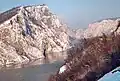 The Kazan Gorge
 -
-
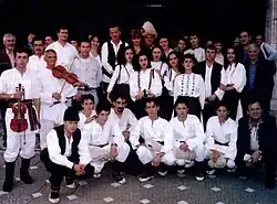 Folkloric group in Vlach traditional costumes from Jabukovac
References
- ^ https://publikacije.stat.gov.rs/G2023/Pdf/G20234001.pdf
- ^ a b Živković 2014, p. 409.
- ^ Timoc, Cristea Sandu (1988). Povești populare românești (in Romanian). București: Editura Minerva. pp. 19–.
- ^ Sandu Timoc, Cristea (2007). Poezii populare de la românii din Timoc: Nord-estul Serbiei și nord-vestul Bulgariei (in Romanian). Bucureşti: Editura Ager. ISBN 978-973-7961-42-6.
- ^ a b Coman, Marian (2016). "Frontiera sârbească a Țării Românești în vremea lui Mircea cel Bătrân". Putere și teritoriu: Țara Românească medievală (secolele XIV-XVI) (in Romanian). Iaşi: Polirom. ISBN 978-9-73463-403-3.
- ^ Srejovic, Dragoslav (n.d.). "Kulture bakarnog i ranog bronzanog doba na tlu Srbije". Projekat Rastko (in Serbian).
- ^ Dabić, Vojin S. (2011). "The Habsburg-Ottoman War of 1716-1718 and Demographic Changes in War-Afflicted Territories". In Ingrao, Charles W.; Samardžić, Nikola; Pesalj, Jovan (eds.). The Peace of Passarowitz, 1718. West Lafayette, Indiana: Purdue University Press. pp. 200–. ISBN 978-1-55753-594-8.
- ^ "Romanii din Valea Timocului, recunoscuti drept minoritate nationala". România liberă (in Romanian). 16 August 2007. Archived from the original on 2007-09-26. Retrieved 2007-10-19.
- ^ https://publikacije.stat.gov.rs/G2023/Pdf/G20234001.pdf
- ^ "Monthly and annual means, maximum and minimum values of meteorological elements for the period 1981–2010". Republic Hydrometeorological Service of Serbia (in Serbian). Retrieved February 25, 2017.
Sources
- Paunović, Marinko (1970). Đerdap i Timočka Krajina (in Serbian). Binoza.
- Timočka Krajina Тимочка Крајина (in Serbian). Beograd: Izd. Udruženja Timočana i Krajinaca. 1928.
- Istorijski institut; Međuopštinski odbor za obeležavanje sto pedesetogodišnjice oslobođenja Timočke krajine od Turaka (1988). Timočka krajina u XIX veku: zbornik radova Тимочка крајина у XIX веку: Зборник радова (in Serbian). Istorijski institut.
- Božić, Sofija (2014). Историја и географија: Сусрети и прожимања / History and geography: Meetings and permeations (in Serbian and English). Beograd: Institut za nоviju istоriju Srbije, Geоgrafski institut "Jоvan Cvijić" SАNU, Institut za slavistku Ran. pp. 409–. ISBN 978-86-7005-125-6.
