Tervola
Tervola | |
|---|---|
Municipality | |
| Tervolan kunta Tervola kommun | |
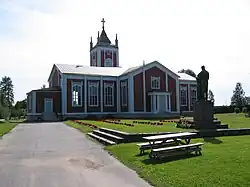 Tervola Church | |
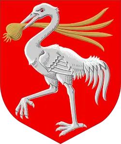 Coat of arms | |
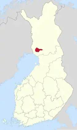 Location of Tervola in Finland | |
OpenStreetMap Interactive map outlining Tervola. | |
| Coordinates: 66°05′20″N 024°48′40″E / 66.08889°N 24.81111°E | |
| Country | |
| Region | Lapland |
| Sub-region | Kemi–Tornio |
| Government | |
| • Municipal manager | Mika Simoska |
| Area (2018-01-01)[1] | |
• Total | 1,592.03 km2 (614.69 sq mi) |
| • Land | 1,559.72 km2 (602.21 sq mi) |
| • Water | 32.66 km2 (12.61 sq mi) |
| • Rank | 41st largest in Finland |
| Population (2025-06-30)[2] | |
• Total | 2,820 |
| • Rank | 221st largest in Finland |
| • Density | 1.81/km2 (4.7/sq mi) |
| Population by native language | |
| • Finnish | 96.6% (official) |
| • Others | 3.4% |
| Population by age | |
| • 0 to 14 | 15.4% |
| • 15 to 64 | 54.9% |
| • 65 or older | 29.6% |
| Time zone | UTC+02:00 (EET) |
| • Summer (DST) | UTC+03:00 (EEST) |
| Website | tervola |
Tervola is a municipality of Finland. It is located in the province of Lapland, Finland. The municipality has a population of 2,820 (30 June 2025)[2] and covers an area of 1,592.03 square kilometres (614.69 sq mi) of which 32.66 km2 (12.61 sq mi) is water.[1] The population density is 1.81 inhabitants per square kilometre (4.7/sq mi).
Neighbour municipalities are Keminmaa, Ranua, Rovaniemi, Simo, Tornio and Ylitornio. The municipality is unilingually Finnish.
The municipal coat of arms is inspired by the agricultural history of Tervola. The crane in the coat of arms refers to the swamps, from which a large part of the area's fields were cleared. The onion, in turn, is one of the plant species that thrives in these fields. The coat of arms was designed by Ahti Hammar and was adopted on February 15, 1957.[6]
History
Tervola is named after its first Finnish settler, a Savonian named Olli Paavonpoika Tervonen, mentioned on a tax list from the year 1579. The part of the Kemijoki between Paakkola and Rovaniemi was essentially uninhabited before his family's arrival.
The area was originally subordinate to Kemi, becoming a chapel community in 1627 under the name Lapinniemi, while the settlement name Tervola was first mentioned in 1796. Tervola became an independent parish in 1860.[7]
References
- ^ a b "Area of Finnish Municipalities 1.1.2018" (PDF). National Land Survey of Finland. Retrieved 30 January 2018.
- ^ a b "Population increased most in Uusimaa in January to June 2025". Population structure. Statistics Finland. 2025-07-24. ISSN 1797-5395. Retrieved 2025-07-24.
- ^ "Number of foreign-language speakers exceeded 600,000 during 2024". Population structure. Statistics Finland. 2025-04-04. ISSN 1797-5395. Retrieved 2025-04-05.
- ^ "Population according to age (1-year) and sex by area and the regional division of each statistical reference year, 2003–2020". StatFin. Statistics Finland. Retrieved 2 May 2021.
- ^ a b "Luettelo kuntien ja seurakuntien tuloveroprosenteista vuonna 2023". Tax Administration of Finland. 14 November 2022. Retrieved 7 May 2023.
- ^ Suomen kunnallisvaakunat (in Finnish). Suomen Kunnallisliitto. 1982. p. 163. ISBN 951-773-085-3.
- ^ "SuomalainenPaikannimikirja_e-kirja_kuvallinen.pdf" (PDF). kaino.kotus.fi (in Finnish). p. 455. Retrieved October 2, 2022.
External links
![]() Media related to Tervola at Wikimedia Commons
Media related to Tervola at Wikimedia Commons
- Municipality of Tervola – Official website (in Finnish)
| Municipalities |  | |
|---|---|---|
| Former municipalities | ||