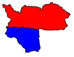
Tatkon Township
Tatkon Township
တပ်ကုန်းမြို့နယ် Tatkone Township | |
|---|---|
 Tatkon Township (red) in Ottara District | |
| Coordinates: 20°7′N 96°13′E / 20.117°N 96.217°E | |
| Country | |
| Territory | Naypyidaw Union Territory |
| District | Ottara District |
| Capital | Tatkon |
| Township established | 5-7-1960 |
| Area | |
• Township | 695.9 sq mi (1,802.3 km2) |
| Dimensions | |
| • Length | 46.375 mi (74.633 km) |
| • Width | 18.625 mi (29.974 km) |
| Highest elevation (Byingye Taung) | 6,252 ft (1,906 m) |
| Lowest elevation | 450 ft (137 m) |
| Population (2014) | |
• Township | 217,093 |
| • Density | 312/sq mi (120.5/km2) |
| • Urban | 41,683 |
| • Rural | 175,410 |
| Time zone | UTC+6:30 (MMT) |
| Postal Code | 1503 |
| Area code | 067- |
| Vehicle registration | NPW-6 |
Tatkon Township (/'tæt koʊn/) (Burmese: တပ်ကုန်းမြို့နယ်) is one of eight townships of Naypyidaw Union Territory, Myanmar. Its principal town is Tatkon and according to the 2014 census, Tatkon Township had a population of 217,093.[1]
Tatkon Township was officially recognized as a township by the Township Administration Division, Department of Home Affairs, Notification No. (573) dated (5-7-1960).[2]
History
The area around Tatkon Township is believed to have been inhabited since the Pyu period. In particular, an ancient Pyu town and burial grounds have been found near Nyaunggaing village.[3]
During the Bagan period, Shwemyo village was included in the 43 Border Towns of King Anawrahta.[4]
Initially under the rule of the Yamethin territory, it came under Taungoo territory up to Nyaunglunt village when King Mingyi Nyo succeeded Taungoo in 847. Shwemyo and Kintha villages were included in 52 Towns of Taungoo during that period.[5]
After the Second Anglo-Burmese War in 1852, the British took over the lower Burma, including Taungoo, and the current Tatkon Township area remained under the rule of the Burmese King and returned to the Yamethin territory.[6]
The present-day areas of Tatkon Township were under the Eastern Division during the colonial period. It includes Paunglaung Township and Taungnyo Township under Pyinmana District, and Yamethin Township under Yamethin District. Generally, the northern part of Sinthe River falls within Yamethin District, while the southern part of Sinthe River falls within Pyinmana District.[7] In 1900, a police station was established in Nyaunggaing village, and it governed the sub-district area covering Nyaunglunt-Temyint-Sedo-Kyaunggon-Kintha-Magyigon-Dwakkyaw-Myaukhmyaik. This may be the beginning of what would later become Tatkon Township area. During the Japanese era, the police station was moved from Nyaunggaing to Tatkon.[8]
After independence, the township was officially inaugurated in 1957, and in 1960, it was officially declared a township by the Home Affairs Department. At that time, Tatkon Township was composed of Shwemyo Sub-Township and Ainggye Sub-Township.[8]
Then, in successive periods, it was a township in Yamethin District, Mandalay Division but was incorporated into Pyinmana District when Pyinmana District was formed to establish Naypyidaw in 2006. When the new 5 Thiri townships of Naypyidaw were formed, the southern village tracts of Tatkon Township, including Nanaw, Khitaye, Kyaukpya, Wegyi, Pyokkwe, Pazunzeik, Nyaunglu, Tatshein, were transferred to these townships. Then, under the 2008 Constitution, it became a township under Ottara District, Naypyidaw Union Territory, in 2010.[9]
Geography
Tatkon Township is located between the Shan Yoma Mountains to the east and the Bago Yoma Mountains to the west, with only about 20% of the township being flat, with the rest being forest and ravines. The elevation ranges from 450 feet to 6,252 feet above sea level. Byingye Taung (Mt Byingye), at 6,252 feet, is the highest peak in Tatkon Township and forms the boundary between Tatkon Township and Pinlaung Township.[10]
The Sinthe and Nawin streams, which are the main watersheds of Tatkon Township, flow from north to south. Nawin stream flows through the middle of the township from north to south, and its basin is the main plain of the township. It flows into Sinthe near Zeegon (Asone) village, where it continues south as Sinthe. Other notable creeks include Nyaunggaing creek, Mon creek, Kintha creek and Myohla creek.[10]
Demographics
2014
| Year | Pop. | ±% |
|---|---|---|
| 2014 | 217,093 | — |
The 2014 Myanmar Census reported that Tatkon Township had a population of 217,093.[1] The population density was 120.5 people per km².[1] The census reported that the median age was 28.1 years, and 92 males per 100 females.[1] There were 51,747 households; the mean household size was 4.1.[1]
Ethnic makeup
The Bamar effectively make up the entirety of the township's population.[2]
References
- ^ a b c d e "Tatkon Township Report" (PDF). 2014 Myanmar Population and Housing Census. October 2017.
- ^ a b "တပ်ကုန်းမြို့နယ် ဒေသဆိုင်ရာအချက်အလက်များ" [Tatkon Township Regional Facts] (PDF). General Administration Department (in Burmese). 2019-09-30. p. 8.
- ^ Zaw, Naing. ပျူနိုင်ငံတော်နှင့် ပျူနိုင်ငံသားများ [The Pyu State and Pyu People] (in Burmese).
- ^ Aung Kyaing, Minbu (2014). အနော်ရထာ၏ကင်းတပ် ၄၃ မြို့ [43 Border Towns of King Anawrahta] (in Burmese).
- ^ Kaytu, Thaung. တောင်ငူ ၅၂ မြို့ ရှာပုံတော် [Exploration of the 52 Towns of Ancient Taungoo] (in Burmese).
- ^ Sayardaw, Sin Kyone (2010). ရမည်းသင်းခရိုင်သမိုင်းနှင့် ရမည်းသင်းရာဇဝင် [History of Yamethin District and Yamethin Cronicles] (in Burmese) (2nd ed.).
- ^ 1937, Maps of Burma in 1 Inch = 1 Mile Scale
- ^ a b GAD (1969). တပ်ကုန်းမြို့နယ်ဖြစ်စဉ်သမိုင်း [History of Tatkon Township] (in Burmese). GAD.
- ^ History of Naypyidaw, https://myanmar.gov.mm/naypyitaw-council
- ^ a b 2005, Myanmar UTM Maps
