Province of Syracuse
Province of Syracuse
| |
|---|---|
| Free Municipal Consortium of Syracuse Libero consorzio comunale di Siracusa (Italian) | |
 Santa Maria della Concezione, the provincial seat | |
 Flag  Coat of arms | |
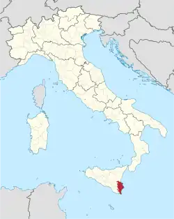 Map highlighting the location of the province of Syracuse in Italy | |
| Country | |
| Region | |
| Capital(s) | Syracuse |
| Municipalities | 21 |
| Government | |
| • President | Michelangelo Giansiracusa |
| Area | |
• Total | 2,124.13 km2 (820.13 sq mi) |
| Population (2025)[2] | |
• Total | 382,690 |
| • Density | 180/km2 (470/sq mi) |
| GDP | |
| • Total | €11.300 billion (2022) |
| • Per capita | €29,300 (2022) |
| Time zone | UTC+1 (CET) |
| • Summer (DST) | UTC+2 (CEST) |
| Postal code | 96100, 96010-96019 |
| Telephone prefix | 0931, 095 |
| Vehicle registration | SR |
| ISTAT | 089 |
| Website | www |
The province of Syracuse (Italian: provincia di Siracusa; Sicilian: pruvincia di Saragusa) was a province in the autonomous island region of Sicily, Italy. Its capital was the city of Syracuse, a town established by Greek colonists arriving from Corinth in the 8th century BC.[4] It had an area of 2,124 square kilometres (820 sq mi) and a total population of 403,985 in 2016. Syracuse had 8% of the Sicilian population and 8.2% of Sicily's area.
Following the suppression of the Sicilian provinces, it was replaced in August 2015 by the free municipal consortium of Syracuse (Italian: libero consorzio comunale di Siracusa).[5]
Geography
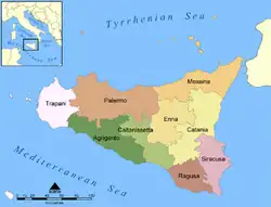
The province of Syracuse lies in the southeastern Sicily, in southwestern Italy. It is bordered to the north and north-west by the province of Catania to the west by the province of Ragusa, and to the east and south by the Ionian and Mediterranean seas. It occupies an area of 2,109 square kilometres (814 sq mi). In 2002, ancient centres of Noto, Palazzolo Acreide and six other towns in the Noto Valley, were awarded UNESCO World Heritage Site status, and is a significant attraction due to its historical, architectural, artistic and archaeological interest. The towns are particularly dense with late Baroque architecture, dates to the immense rebuilding of the towns which took place after the 1693 earthquake which devastated Sicily.[6] The Park of Neapolis on the island of Ortygia is connected by three bridges to the mainland.[7] The island contains the Castello Maniace, dated to the Hohenstaufen period and the Doric Temple of Athena, which was renovated by the Normans.[7]
The Hyblaean Mountains are the dominant mountain range in the province, sloping down to a coastline which contains stretches of white sandy beaches, cliffs, bays, and islets.[7] The coast to the south of Syracuse contains numerous protected areas, such as the Area Marina Protetta del Plemmirio, the Riserva Naturale Orientara Cavagrande between Cassibile and Avola, and the Riserva Naturale Orientata faunistica di Vendicar, north of Pachino.[8] Within the province lies Lago di Lentini, the largest lake in Sicily,[9] and reputedly the largest artificial lake in Europe, which supports a marshland habitat with over 150 different species.[10]
Municipalities
There are 21 municipalities (comuni) in the province:[11]
Demographics
As of 2025, there are 382,690 people residing in the former province, of whom 49.4% are male and 50.6% are female. Minors make up 15.5% of the population, and pensioners make up 23.7%. This compares with the Italian average of 14.9% minors and 24.7% pensioners.[2]
|
| ||||||||||||||||||||||||||||||||||||||||||||||||||||||
| Source: ISTAT[12][13] | |||||||||||||||||||||||||||||||||||||||||||||||||||||||
References
- ^ "Superficie di Comuni Province e Regioni italiane al 9 ottobre 2011" (in Italian). ISTAT.
- ^ a b "Monthly Demographic Balance". ISTAT.
- ^ Regions and Cities > Regional Statistics > Regional Economy > Regional Gross Domestic Product (Small regions TL3), OECD.Stats. Accessed on 16 November 2018.
- ^ Ring, Trudy; Salkin, Robert M.; Boda, Sharon La (1995). International Dictionary of Historic Places: Southern Europe. Taylor & Francis. p. 674. ISBN 978-1-884964-02-2.
- ^ "Città metropolitane-legge 4 agosto 2015 n 15" (PDF) (in Italian).
- ^ "Late Baroque Towns of the Val di Noto (South-Eastern Sicily)". UNESCO. Retrieved 29 September 2014.
- ^ a b c "Syracuse". Italia.it. Archived from the original on 22 April 2019. Retrieved 29 September 2014.
- ^ "Province of Syracuse" (Map). Google Maps. Retrieved 29 September 2014.
- ^ Colt Hoare, Sir Richard (1819). A classical tour through Italy and Sicily. p. 425.
- ^ "Biviere di Lentini" (in Italian). Siracusaturismo.net. Retrieved 29 September 2014.
- ^ "Statistiche demografiche". Istituto Nazionale di Statistica. Retrieved 29 September 2014.
- ^ "Popolazione residente dei comuni. Censimenti dal 1861 al 1991" [Resident population of the municipalities. Censuses from 1861 to 1991] (PDF) (in Italian). ISTAT.
- ^ "Dashboard Permanent census of population and housing". ISTAT.
External links
- (in Italian) Official Province website
- Pictures, history, tourism, gastronomy, books, local products, local surnames, transportation in the province of Syracuse
