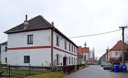
Strýčice
Strýčice | |
|---|---|
 Municipal office | |
 Flag  Coat of arms | |
 Strýčice Location in the Czech Republic | |
| Coordinates: 49°0′43″N 14°15′56″E / 49.01194°N 14.26556°E | |
| Country | |
| Region | South Bohemian |
| District | České Budějovice |
| First mentioned | 1292 |
| Area | |
• Total | 0.64 km2 (0.25 sq mi) |
| Elevation | 423 m (1,388 ft) |
| Population (2025-01-01)[1] | |
• Total | 54 |
| • Density | 84/km2 (220/sq mi) |
| Time zone | UTC+1 (CET) |
| • Summer (DST) | UTC+2 (CEST) |
| Postal code | 373 41 |
| Website | www |
Strýčice (German: Stritschitz) is a municipality and village in České Budějovice District in the South Bohemian Region of the Czech Republic. It has about 50 inhabitants.
Geography
Strýčice is located about 15 kilometres (9 mi) west of České Budějovice. It lies in a flat agricultural landscape, on the border between the České Budějovice Basin and Bohemian Forest Foothills. The highest point is at 438 m (1,437 ft) above sea level. The area is rich in fishponds.
With an area of 0.64 km2 (0.25 sq mi), Strýčice is the third smallest municipality in the country.[2]
Demographics
| Year | Pop. | ±% |
|---|---|---|
| 1869 | 92 | — |
| 1880 | 91 | −1.1% |
| 1890 | 88 | −3.3% |
| 1900 | 78 | −11.4% |
| 1910 | 74 | −5.1% |
| 1921 | 80 | +8.1% |
| 1930 | 83 | +3.8% |
| 1950 | 64 | −22.9% |
| 1961 | 91 | +42.2% |
| 1970 | 102 | +12.1% |
| 1980 | 75 | −26.5% |
| 1991 | 59 | −21.3% |
| 2001 | 50 | −15.3% |
| 2011 | 53 | +6.0% |
| 2021 | 55 | +3.8% |
| Source: Censuses[3][4] | ||
References
- ^ "Population of Municipalities – 1 January 2025". Czech Statistical Office. 2025-05-16.
- ^ "Municipalities – the smallest, the largest" (PDF). Czech Statistical Office. Retrieved 2025-08-09.
- ^ "Historický lexikon obcí České republiky 1869–2011" (in Czech). Czech Statistical Office. 2015-12-21.
- ^ "Population Census 2021: Population by sex". Public Database. Czech Statistical Office. 2021-03-27.
External links
Wikimedia Commons has media related to Strýčice.