Finnish regional road 280
 | |
|---|---|
Somero Road
| |
 | |
| Route information | |
| Length | 42 km (26 mi) |
| Major junctions | |
| From | Somero |
| To | Näkkilä, Lohja |
| Location | |
| Country | Finland |
| Highway system | |
Finnish regional road 280 (Finnish: Seututie 280, Swedish: Regionalväg 280), or Somero Road (Finnish: Somerontie, Swedish: Somerosvägen), is the road between highway 52 and road 110. At the southern end it starts near the village of Näkkilä in Lohja, Uusimaa and at the northern end from the town centre of Somero, Southwest Finland.
The road has traditionally formed the most important road connection between Somero and Helsinki. However, after Highway 1 was completed as a motorway, it has been found that the connection road 2410 leading from Highway 1 to Somero via Kiikala offers an almost equally fast route from Somero to Helsinki; although the journey is longer, the longer section of motorway is said to increase safety.[1] Before the current Highway 2 was completed in the 1960s, the section of current regional road 280 from the intersection of current regional road 125 in Nummi-Pusula to current road 52 in Somero was part of Highway 2.[2][3]
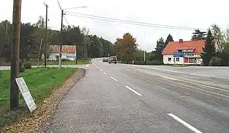
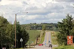
The initial part of the road is dominated by cultivated valleys with villages, into which the edge formations of the second and third Salpausselkä with their longitudinal ridges intertwine in Pusula and Somerniemi, and the ridges also continue in Somero.[4][5] There are no fewer than three manors along the road in Somero.[6] Also, in the village of Hirsjärvi, about 9 kilometres (5.6 mi) from the town centre of Somero and about 5 kilometres (3.1 mi) from Somerniemi, there is a kiosk along the regional road that is served as a memorial to singer Rauli "Badding" Somerjoki (1947–1987) since 1997.[7]
Route
- Lohja
- Näkkilä
- Koisjärvi
- Hyönölä
- Somero
- Somerniemi
- Hirsjärvi
- Somero
See also
References
- ^ "Sujuva tieyhteys Helsinkiin siintää Kiikalan kautta". Somero-lehti (in Finnish). Somero. 18 January 2010.
- ^ Grönroos, Matti. "Valtatie 2 Palojärvi(Vihti)-Mäntyluoto (Pori), 227 km". Kyläteistä valtaväyliin: Suomen pääteiden kuvauksia ja historiaa (in Finnish). Matti Grönroos. Retrieved 24 July 2025.
- ^ Grönroos, Matti. "Kantatie 52 Tammisaari-Jokioinen, 111 km". Kyläteistä valtaväyliin: Suomen pääteiden kuvauksia ja historiaa (in Finnish). Matti Grönroos. Retrieved 24 July 2025.
- ^ Glückert, Gunnar (1975). The second Salpausselkä at Karkkila, Southern Finland. Helsinki: Geological Society of Finland. pp. 45–53.
- ^ Aartolahti, Toive (1968). Die Geomorphologie des Gebiets von Tammela, Südfinnland (in German). Helsinki: Geological Society of Finland.
- ^ Lehtonen, Kaarin (1990). Someron ja Somerniemen kulttuurimaisema ja vanha rakennuskanta (in Finnish). Turku: Turun maakuntamuseo. pp. 50–57. ISBN 951-9125-77-9.
- ^ "Baddingin kioski on Rauli Somerjoen muistomerkki". Yle (in Finnish). 13 July 2009. Retrieved 24 July 2025.
External links
![]() Media related to National road 280 (Finland) at Wikimedia Commons
Media related to National road 280 (Finland) at Wikimedia Commons
- Autoilijan tiekartta 2007 (in Finnish). Helsinki: AffectoGenimap Finland Oy. 2006. ISBN 978-951-593-047-7.