Sirník
Sirník
Szürnyeg | |
|---|---|
 | |
 Flag | |
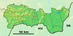 Sirník Location of Sirník in the Košice Region  Sirník Location of Sirník in Slovakia | |
| Coordinates: 48°31′N 21°49′E / 48.52°N 21.82°E | |
| Country | |
| Region | |
| District | Trebišov District |
| First mentioned | 1403 |
| Area | |
• Total | 5.82 km2 (2.25 sq mi) |
| Elevation | 110 m (360 ft) |
| Population (2021)[3] | |
• Total | 551 |
| Time zone | UTC+1 (CET) |
| • Summer (DST) | UTC+2 (CEST) |
| Postal code | 760 3[2] |
| Area code | +421 56[2] |
| Car plate | TV |
| Website | www |
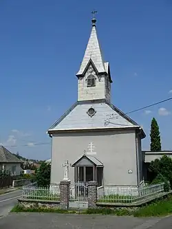
Sirník (Hungarian: Szürnyeg) is a village and municipality in the Trebišov District in the Košice Region of south-eastern Slovakia.
History
In historical records the village was first mentioned in 1403.
Geography
The village lies at an altitude of 128 metres and covers an area of 5.822 km². It has a population of about 605 people.
Ethnicity
The village is about 71% Slovak, 25% Hungarian and 4% Gypsy.
Facilities
The village has a public library.
References
- ^ "Hustota obyvateľstva - obce [om7014rr_ukaz: Rozloha (Štvorcový meter)]". www.statistics.sk (in Slovak). Statistical Office of the Slovak Republic. 2022-03-31. Retrieved 2022-03-31.
- ^ a b c "Základná charakteristika". www.statistics.sk (in Slovak). Statistical Office of the Slovak Republic. 2015-04-17. Retrieved 2022-03-31.
- ^ "Počet obyvateľov podľa pohlavia - obce (ročne)". www.statistics.sk (in Slovak). Statistical Office of the Slovak Republic. 2022-03-31. Retrieved 2022-03-31.