Sebuzín
Sebuzín | |
|---|---|
Village | |
 Chapel of Saint Vincent Ferrer | |
 Sebuzín Location in the Czech Republic | |
| Coordinates: 50°35′40″N 14°3′54″E / 50.59444°N 14.06500°E | |
| Country | |
| Region | Ústí nad Labem |
| District | Ústí nad Labem |
| Municipality | Ústí nad Labem |
| First mentioned | 1251 |
| Area | |
• Total | 7.24 km2 (2.80 sq mi) |
| Elevation | 158 m (518 ft) |
| Population (2021)[1] | |
• Total | 503 |
| • Density | 69/km2 (180/sq mi) |
| Time zone | UTC+1 (CET) |
| • Summer (DST) | UTC+2 (CEST) |
| Postal code | 403 02 |
Sebuzín is a village and municipal part of Ústí nad Labem in Ústí nad Labem District in the Ústí nad Labem Region of the Czech Republic. It is located on the right bank of the Elbe River. Until 1980, it was a separate municipality.
Etymology
The initial name of the village was probably Chcebuzín. The name was derived from the personal name Chcebud, meaning "Chcebud's".[2]
Geography
Sebuzín is located in the southernmost part of the territory of Ústí nad Labem and within the České středohoří Protected Landscape Area. It lies in the Central Bohemian Uplands. The highest point is the hill Matrý at 594 m (1,949 ft) above sea level. The municipal part is situated on the right bank of the Elbe River.
History
The first written mention of Sebuzín is from 1251. Until 1580, it was owned by a local noble family who called themselves Barons of Sebuzín. After 1580, the village was divided into two parts that had different owners. The first part belonged to the Litoměřice estate and later to the Lovosice estate. The second part belonged to the Kamýk estate. The sovereign municipality of Sebuzín was established in 1848, but in 1980, it was merged with Ústí nad Labem.[3]
Demographics
|
|
| ||||||||||||||||||||||||||||||||||||||||||||||||||||||
| Source: Censuses[4][1] | ||||||||||||||||||||||||||||||||||||||||||||||||||||||||
Transport

Sebuzín is located on the railway line Ústí nad Labem–Lysá nad Labem.[5]
Sights
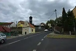
The main historical landmark of Sebuzín is the Chapel of Saint Vincent Ferrer. It was built in the late Baroque style in 1745. There is a sculpture in the niche and an iron bell in the pinnacle.[6]
References
- ^ a b "Výsledky sčítání 2021 – otevřená data" (in Czech). Czech Statistical Office. 2022-12-21.
- ^ Profous, Antonín (1957). Místní jména v Čechách IV: S–Ž (in Czech). p. 17.
- ^ Martinka, Lukáš. Střekov: Kresby historické literatury (PDF) (in Czech). Obec Dýšina. pp. 3, 45. ISBN 978-80-87625-91-0.
- ^ "Historický lexikon obcí České republiky 1869–2011" (in Czech). Czech Statistical Office. 2015-12-21.
- ^ "Detail stanice Sebuzín" (in Czech). České dráhy. Retrieved 2024-07-24.
- ^ "Kaple sv. Anny" (in Czech). National Heritage Institute. Retrieved 2025-07-23.