Seana Bhaile
| Scottish Gaelic name | Fraoch-eilean |
|---|---|
| Meaning of name | "heather island" |
 | |
| Location | |
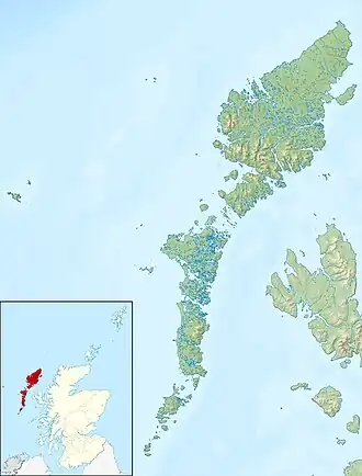 Seana Bhaile Seana Bhaile shown within Scotland | |
| OS grid reference | NF858581 |
| Coordinates | 57°30′14″N 7°14′53″W / 57.504°N 7.248°W |
| Physical geography | |
| Island group | Uists and Barra |
| Area | 55 ha[1] |
| Area rank | 189= [3] |
| Highest elevation | Cnoc Mòr, 11 m (36 ft)[2] |
| Administration | |
| Council area | Na h-Eileanan Siar |
| Country | Scotland |
| Sovereign state | United Kingdom |
| Demographics | |
| Population | 15[4] |
| Population rank | 66 [3] |
| Population density | 30/km2 (78/sq mi)[1][4] |
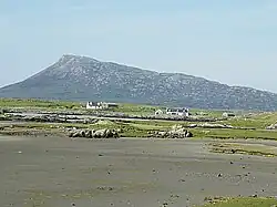
Seana Bhaile is a small inhabited island north of Benbecula in the Outer Hebrides of Scotland. It is about 55 hectares (140 acres) in extent and the highest point is 11 metres (36 ft).
Name
There has been some confusion about the name of the island. For example, the 2022 census 'release note' for Scottish islands states "We have been made aware of an incorrect name of an island on our Island map. Island code 177; Fraoch-eilean; Corrected – Seana Bhaile."[5]
Fraoch-eilean means "heather island" in Scottish Gaelic and there are several other islands in Scotland with similar names.
Seana Bhaile means "old township" and similarly it is a name used elsewhere in the Gàidhealtachd.
19th and early 20th century Ordnance Survey maps seemingly show the island name as Seanabaily.[6] In the modern Ordnance Survey maps at 1:50,000 the name Seana Bhaile is used but it is not clear if this is a settlement or an island name.[2] At 1:25,000 The OS show both names with Seana Bhaile being written in larger letters than Fraoch-eilean,[2] although the latter is a more likely name for an island. There is however some precedent for the former. Baleshare is an island to the northwest. The name means "east town". The "west town" may have been on land that was said to exist to the west that was washed away in the sixteenth century.[7]
OpenSeaMap show the island name as Fraoch-eilean with Seana Bhaile being identified as a small settlement on the north coast.[8]
It seems clear from the older maps and satellite imagery that Fraoch-eilean is the name of an abandoned farm or small settlement on an elevation in the south east of the island of Seana Bhaile which is largely surrounded by tidal waters to the south and salt marsh to the north. Neither Fraoch-eilean nor Seana Bhaile are listed by Haswell-Smith (2004).
Geography
The island is connected to Grimsay by a causeway. North Uist is to the north and the North Ford causeway to the west. The small islets of Eilean Roinoch and Màs Grimsay lie just offshore to the east and Eilean a' Ghiorr on the Oitir Mor causeway is to the west.
Population
The island was not listed in either the 2001 census as being inhabited,[9] or in the 2011 census[10] although it is clear from both maps[2] and photographic evidence[11][12] that there was a resident population. The problems of defining islands in this part of the Hebrides are considerable[Note 1] and at that time it is likely that the population was recorded as being part of Grimsay itself, which has a population of 169 in 2011.[Note 2][Note 3] Ordnance Survey maps indicate a total of about a dozen buildings.[2]
In 2022 the census recorded a population for the island of 15 under the name "Seana Bhaile".[4]
Footnotes
- ^ For example, Haswell-Smith (2004) treats Eileanan Iasgaich (grid reference NF785186) as a single island of 50 ha, although during some high tides it becomes several tidal islets - none of which are ever connected to the "mainland" of South Uist.[13]
- ^ In 2001 the General Register Office for Scotland defined an island as "a mass of land surrounded by water, separate from the Scottish mainland" and although the inclusion of islands linked by bridges etc. is not clear from this definition in practice they list several. There are however several smaller bridged islands that are likely to be inhabited from time to time they did not provide a population statistic for - see this list.
- ^ In 2022 Grimsay's population had declined by 20 to 149.[4]
Citations
- ^ a b Rick Livingstone’s Tables of the Islands of Scotland (pdf) Argyll Yacht Charters. Retrieved 12 Dec 2011.
- ^ a b c d e "Get-a-Map". Ordnance Survey. Retrieved 21 August 2009.
- ^ a b Area and population ranks: there are c. 300 islands over 20 ha in extent. 93 permanently inhabited islands were listed in the 2011 census and 101 such islands in 2022.
- ^ a b c d "Scottish Islands Data Dashboard". RESAS/Scottish Government. 2025. p. 6. Retrieved 1 June 2025.
- ^ "Geography: Census 2022 – How the Census Geographies were created Information Note: Census Island Groups". National Records of Scotland. (30 October 2024) Retrieved 6 July 2025.
- ^ "Historical maps". Vision of Britain. Retrieved 18 Apr 2011.
- ^ Haswell-Smith, Hamish (2004). The Scottish Islands. Edinburgh: Canongate. p. 245. ISBN 978-1-84195-454-7.
- ^ "Open Sea Maps". Retrieved 19 July 2025.
- ^ General Register Office for Scotland (28 November 2003) Scotland's Census 2001 – Occasional Paper No 10: Statistics for Inhabited Islands. Retrieved 26 February 2012.
- ^ National Records of Scotland (15 August 2013). "Appendix 2: Population and households on Scotland's Inhabited Islands" (PDF). Statistical Bulletin: 2011 Census: First Results on Population and Household Estimates for Scotland Release 1C (Part Two) (PDF) (Report). SG/2013/126. Retrieved 15 July 2025.
- ^ Fergusson, Dave (24 May 2007) "Houses on Seana Bhaile" Geograph. Retrieved 21 August 2009.
- ^ Wilding, Stuart (20 June 2008) "Gearraidh Dubh" Geograph. Retrieved 21 August 2009.
- ^ Haswell-Smith (2004) pp. 233-34