Sarben, Nebraska
Sarben, Nebraska | |
|---|---|
 "A" Street in Sarben | |
 Sarben  Sarben | |
| Coordinates: 41°09′59″N 101°18′16″W / 41.16639°N 101.30444°W | |
| Country | United States |
| State | Nebraska |
| County | Keith |
| Area | |
• Total | 0.16 sq mi (0.41 km2) |
| • Land | 0.16 sq mi (0.41 km2) |
| • Water | 0.00 sq mi (0.00 km2) |
| Elevation | 3,005 ft (916 m) |
| Population (2020) | |
• Total | 31 |
| • Density | 197.45/sq mi (76.34/km2) |
| Time zone | UTC-7 (Central (CST)) |
| • Summer (DST) | UTC-6 (CDT) |
| ZIP Code | 69155 |
| Area code | 308 |
| FIPS code | 31-43560 |
| GNIS feature ID | 2583898[2] |
Sarben is an unincorporated rural hamlet in Keith County, Nebraska, United States.[3] There are no businesses or services in Sarben. Since 2010, Sarben has been part of the United States Census Bureau's census-designated place (CDP) which bears the hamlet's name.
As of the 2010 census the Sarben CDP had a total population of 31.[4] A Census Bureau population for Sarben proper is not, however, available.
History
Sarben had its start by the building of the Union Pacific Railroad through that territory.[5] Sarben took its name from "Aksarben", or "Nebraska" spelled backwards.[6][7]
Geography
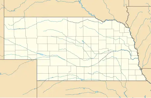
Sarben is in eastern Keith County, in the valley of the North Platte River. It is 5 miles (8 km) via local roads northeast of Paxton and 10 miles (16 km) west of Sutherland. It is 25 miles (40 km) northeast of Ogallala, the Keith County seat.
According to the U.S. Census Bureau, the Sarben CDP has an area of 0.16 square miles (0.41 km2), all land.[4]
Demographics
| Census | Pop. | Note | %± |
|---|---|---|---|
| 2020 | 31 | — | |
| U.S. Decennial Census[8] | |||
See also
References
- ^ "ArcGIS REST Services Directory". United States Census Bureau. Retrieved September 18, 2022.
- ^ a b U.S. Geological Survey Geographic Names Information System: Sarben, Nebraska
- ^ U.S. Geological Survey Geographic Names Information System: Sarben, Nebraska
- ^ a b "Geographic Identifiers: 2010 Census Summary File 1 (G001), Sarben CDP, Nebraska". American FactFinder. U.S. Census Bureau. Retrieved April 11, 2019.
- ^ Burr, George L.; Buck, O. O. (1921). History of Hamilton and Clay Counties, Nebraska. S.J. Clarke Publishing Company. p. 123.
- ^ "Profile for Sarben, NE". ePodunk. Retrieved August 18, 2014.
- ^ Fitzpatrick, Lillian L. (1960). Nebraska Place-Names. University of Nebraska Press. p. 85. ISBN 0-8032-5060-6.
{{cite book}}: ISBN / Date incompatibility (help) A 1925 edition is available for download at University of Nebraska—Lincoln Digital Commons. - ^ "Census of Population and Housing". Census.gov. Retrieved June 4, 2016.
Municipalities and communities of Keith County, Nebraska, United States | ||
|---|---|---|
| City | 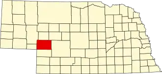 | |
| Villages | ||
| CDPs | ||
| Unincorporated communities | ||