Sarangani, Davao Occidental
Sarangani | |
|---|---|
| Municipality of Sarangani | |
 Flag  Seal | |
Nicknames:
| |
| Motto(s): Sarangani Bayan Natin, Sarangani Paraiso Natin! | |
 Map of Davao Occidental with Sarangani highlighted | |
OpenStreetMap | |
.svg.png) Sarangani Location within the Philippines | |
| Coordinates: 5°24′43″N 125°25′19″E / 5.412°N 125.422°E | |
| Country | Philippines |
| Region | Davao Region |
| Province | Davao Occidental |
| District | Lone district |
| Founded | June 11, 1978 |
| Barangays | 12 (see Barangays) |
| Government | |
| • Type | Sangguniang Bayan |
| • Mayor | Adelan B. de Arce |
| • Vice Mayor | Marciano C. Lagudas |
| • Representative | Claude P. Bautista |
| • Municipal Council | Members |
| • Electorate | 17,122 voters (2025) |
| Area | |
• Total | 97.72 km2 (37.73 sq mi) |
| Elevation | 25 m (82 ft) |
| Highest elevation (Mount Balut) | 1,131 m (3,711 ft) |
| Lowest elevation | 0 m (0 ft) |
| Population (2024 census)[3] | |
• Total | 22,041 |
| • Density | 230/km2 (580/sq mi) |
| • Households | 5,718 |
| Economy | |
| • Income class | 4th municipal income class |
| • Poverty incidence | 41.99 |
| • Revenue | ₱ 142.8 million (2022) |
| • Assets | ₱ 265.4 million (2022) |
| • Expenditure | ₱ 119.2 million (2022) |
| • Liabilities | ₱ 25.45 million (2022) |
| Service provider | |
| • Electricity | Davao del Sur Electric Cooperative (DASURECO) |
| Time zone | UTC+8 (PST) |
| ZIP code | 8015 |
| PSGC | |
| IDD : area code | +63 (0)82 |
| Native languages | Davawenyo Cebuano Sarangani Sangirese Tagalog |
| Website | www |
Sarangani, officially the Municipality of Sarangani (Cebuano: Lungsod sa Sarangani; Tagalog: Bayan ng Sarangani), is a municipality in the province of Davao Occidental, Philippines. According to the 2020 census, it has a population of 22,515 people, making it the least populated municipality in the province.[5]
History
On June 11, 1978, the islands of Sarangani and Balut were carved out from the municipality of Jose Abad Santos to form the new municipality of Sarangani, then in Davao del Sur, through Presidential Decree No. 1550 signed by President Ferdinand Marcos.[6] On October 28, 2013, the municipality was ceded to Davao Occidental as a result of a plebiscite, in which the majority of voters approved the creation of the new province.[7]
Geography
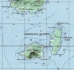
The municipality consists of two major islands (the eponymous Sarangani Island and Balut Island) and one minor islet (Olanivan Island), collectively called the Sarangani Islands, located just south of mainland Mindanao island in the Celebes Sea. The municipality shares a maritime border with Sangihe Islands Regency of Indonesia.[8]
Climate
Sarangani has a tropical rainforest climate (Af) with moderate to heavy rainfall year-round.
| Climate data for Sarangani | |||||||||||||
|---|---|---|---|---|---|---|---|---|---|---|---|---|---|
| Month | Jan | Feb | Mar | Apr | May | Jun | Jul | Aug | Sep | Oct | Nov | Dec | Year |
| Mean daily maximum °C (°F) | 31.5 (88.7) |
31.8 (89.2) |
32.4 (90.3) |
32.7 (90.9) |
32.0 (89.6) |
31.1 (88.0) |
30.8 (87.4) |
31.1 (88.0) |
31.4 (88.5) |
31.8 (89.2) |
31.9 (89.4) |
31.7 (89.1) |
31.7 (89.0) |
| Daily mean °C (°F) | 26.4 (79.5) |
26.6 (79.9) |
27.1 (80.8) |
27.5 (81.5) |
27.3 (81.1) |
26.6 (79.9) |
26.3 (79.3) |
26.5 (79.7) |
26.7 (80.1) |
27.0 (80.6) |
27.0 (80.6) |
26.8 (80.2) |
26.8 (80.3) |
| Mean daily minimum °C (°F) | 21.4 (70.5) |
21.5 (70.7) |
21.8 (71.2) |
22.3 (72.1) |
22.6 (72.7) |
22.2 (72.0) |
21.9 (71.4) |
22.0 (71.6) |
22.1 (71.8) |
22.2 (72.0) |
22.1 (71.8) |
21.9 (71.4) |
22.0 (71.6) |
| Average rainfall mm (inches) | 169 (6.7) |
137 (5.4) |
119 (4.7) |
118 (4.6) |
165 (6.5) |
168 (6.6) |
159 (6.3) |
115 (4.5) |
114 (4.5) |
162 (6.4) |
166 (6.5) |
160 (6.3) |
1,752 (69) |
| Source: Climate-Data.org[9] | |||||||||||||
Barangays
Sarangani is politically subdivided into 12 barangays. Each barangay consists of puroks while some have sitios.
- Batuganding
- Konel
- Lipol
- Mabila (Poblacion)
- Tinina
- Gomtago
- Tagen
- Tucal
- Patuco (Sarangani Norte) (includes Olanivan islet)
- Laker (Sarangani Sur)
- Camahual
- Camalig
Demographics
| Year | Pop. | ±% p.a. |
|---|---|---|
| 1980 | 11,960 | — |
| 1990 | 15,003 | +2.29% |
| 1995 | 16,648 | +1.97% |
| 2000 | 18,391 | +2.16% |
| 2007 | 20,394 | +1.44% |
| 2010 | 23,290 | +4.95% |
| 2015 | 24,039 | +0.60% |
| 2020 | 22,515 | −1.37% |
| Source: Philippine Statistics Authority[10][11][12][13][14] | ||
Due to its proximity to Indonesia, the town also has a significant population of migrants from the Sangihe-Talaud region, including several generations of Indonesian families. As early as 1918, Indonesians extensively planted coconuts in the municipality. Sarangani is also used by Indonesians as a transit point on their way to mainland Mindanao.[15]
Economy
Poverty incidence of Sarangani
10
20
30
40
50
60
70
80
2000
60.63 2003
78.67 2006
54.60 2009
72.12 2012
65.89 2015
59.53 2018
35.47 2021
41.99 Source: Philippine Statistics Authority[16][17][18][19][20][21][22][23] |
Government
Municipal officials 2022-2025:
- Mayor: Adelan B. de Arce
- Vice Mayor: Mariano C. Lagudas
- Councilors:
- Arthon M. Gantongan
- Dionisio D. Wao Jr.
- Alexis C. Forones
- Jay William J. Olarte
- Biyal A. Malong
- Rodilo P. Dalumpines
- Steven A. Olarte
- Jomarie A. Olarte
References
- ^ Municipality of Sarangani | (DILG)
- ^ "2015 Census of Population, Report No. 3 – Population, Land Area, and Population Density" (PDF). Philippine Statistics Authority. Quezon City, Philippines. August 2016. ISSN 0117-1453. Archived (PDF) from the original on May 25, 2021. Retrieved July 16, 2021.
- ^ "2024 Census of Population (POPCEN) Population Counts Declared Official by the President". Philippine Statistics Authority. 17 July 2025. Retrieved 18 July 2025.
- ^ "PSA Releases the 2021 City and Municipal Level Poverty Estimates". Philippine Statistics Authority. 2 April 2024. Retrieved 28 April 2024.
- ^ "2024 Census of Population (POPCEN) Population Counts Declared Official by the President". Philippine Statistics Authority. 17 July 2025. Retrieved 18 July 2025.
- ^ Presidential Decree No. 1550 (June 11, 1979), An Act Creating the Municipality of Sarangani in the Province of Davao Del Sur, The Lawphil Project, retrieved July 26, 2024
- ^ Republic Act No. 10360 (January 14, 2013), An Act Creating the Province of Davao Occidental, The Lawphil Project, retrieved July 26, 2024
- ^ "Life along the borders: The Indonesian Sangirs on Balut Island - Asian Center for Journalism". Asian Center for Journalism. 2014-08-27. Archived from the original on 2024-12-08. Retrieved 2025-05-12.
- ^ "Climate: Sarangani". Climate-Data.org. Retrieved 28 October 2020.
- ^ "2024 Census of Population (POPCEN) Population Counts Declared Official by the President". Philippine Statistics Authority. 17 July 2025. Retrieved 18 July 2025.
- ^ Census of Population (2015). "Region XI (Davao Region)". Total Population by Province, City, Municipality and Barangay. Philippine Statistics Authority. Retrieved 20 June 2016.
- ^ Census of Population and Housing (2010). "Region XI (Davao Region)" (PDF). Total Population by Province, City, Municipality and Barangay. National Statistics Office. Retrieved 29 June 2016.
- ^ Censuses of Population (1903–2007). "Region XI (Davao Region)". Table 1. Population Enumerated in Various Censuses by Province/Highly Urbanized City: 1903 to 2007. National Statistics Office.
- ^ "Province of". Municipality Population Data. Local Water Utilities Administration Research Division. Retrieved 17 December 2016.
- ^ Macario D. Tiu (7 September 2006). "The Indonesian Migrants of Davao and Cotabato". Kyodo Review of Southeast Asia. Retrieved 16 August 2025.
- ^ "Poverty incidence (PI):". Philippine Statistics Authority. Retrieved December 28, 2020.
- ^ "Estimation of Local Poverty in the Philippines" (PDF). Philippine Statistics Authority. 29 November 2005.
- ^ "2003 City and Municipal Level Poverty Estimates" (PDF). Philippine Statistics Authority. 23 March 2009.
- ^ "City and Municipal Level Poverty Estimates; 2006 and 2009" (PDF). Philippine Statistics Authority. 3 August 2012.
- ^ "2012 Municipal and City Level Poverty Estimates" (PDF). Philippine Statistics Authority. 31 May 2016.
- ^ "Municipal and City Level Small Area Poverty Estimates; 2009, 2012 and 2015". Philippine Statistics Authority. 10 July 2019.
- ^ "PSA Releases the 2018 Municipal and City Level Poverty Estimates". Philippine Statistics Authority. 15 December 2021. Retrieved 22 January 2022.
- ^ "PSA Releases the 2021 City and Municipal Level Poverty Estimates". Philippine Statistics Authority. 2 April 2024. Retrieved 28 April 2024.
External links
 Media related to Sarangani, Davao Occidental at Wikimedia Commons
- Sarangani Profile at the DTI Cities and Municipalities Competitive Index
- Philippine Standard Geographic Code
- Philippine Census Information
- Local Governance Performance Management System
Places adjacent to Sarangani, Davao Occidental | ||||||||||||||||
|---|---|---|---|---|---|---|---|---|---|---|---|---|---|---|---|---|
| ||||||||||||||||
Malita (capital and largest municipality) | |
| Municipalities | |