Sanford Riverwalk

The Sanford Riverwalk is a multi-use trail in Sanford, Florida. The path covers 26 miles (42 km) on the shore of Lake Monroe and includes a 3.4-mile (5.5 km) connector to Florida's Coast to Coast connector—linking the west and east coasts of central Florida.[1] The Seminole County World War I Monument is along the trail at Sanford Veterans Memorial Park. The trail runs east to west. Its westernmost point is Mellionville and 1st Streets, and at its easternmost point is Lake Monroe Wayside Park.
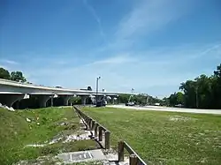
Accessing the park requires crossing US Routes 17-92 (north 17, east 92; they overlap between Lake Alfred in Polk County and Deland in Volusia County) and an exit ramp off exit 104 from Interstate 4. The last point before crossing the Cross Seminole Trail at CST mile marker 27.5. CST follows US-17. Its last part connects the Spring-to-Spring Trail and the Riverwalk. On the Riverwalk is the Sanford Veterans Memorial Park and the Sanford Marina. It connects to the Cross Seminole Trail. The part after I-4 connects CST to the Spring-to-Spring Trail and Coast-to-Coast trail.
Distance markers
| Mile | Kilometer | Attraction |
|---|---|---|
| 0.0 | 0.0 | Start of the Riverwalk at Mellonville Ave. |
| 0.7 | 1.10 | A break in the road to go the Sanford Marina (Palmetto Avenue Crosses here forcing people to use a crosswalk). |
| 0.8 | The entrance to Veterans Memorial Park where there is the Seminole County World War I Monument shown above. | |
| 1.2 | At French Avenue, the road circles to the left while the Riverwalk continues lakeside. A short distance on they re-converge, with the Riverwalk running between a seawall and the roadway - the steel barrier makes it a safe and pleasant bike ride with unrestricted lake views. There are no road crossings. West of the downtown business area, there are fewer pedestrians on this section.[2] | |
| 4.2 | This is the end of the trail according to some people. To the west, at trail's end at US 17/92, it links to the Florida Coast-to-Coast Trail via the Cross Seminole Trail, continuing over the St Johns River bridge to the Spring-to-Spring Trail.[3] |
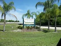
Lake Monroe Wayside Park
This park is located at 4150 US-17, Sanford, FL 32771. It is a spur of US 17/92 under the 17-92 Bridge. It has a boat launch. In 1994, the bridge was replaced by the Bill Benedict Bridge, a much higher concrete slab bridge that has four lanes, and connects the old bridge and a CSX Railroad drawbridge that originally served the Atlantic Coast Line Railroad. The remnants of the bridge can be found there, and now survive as a fishing pier and overlook.
Wayside Boat Ramp is located on the southwest shore of Lake Monroe off of 17-92. Three floating docks and two wide ramps offer enough room for four vessels to launch at once.[4]


References
- ^ "RiverWalk". Sanford Main. Retrieved 2025-06-05.
- ^ "Sanford Riverwalk, 4.5 Miles Lakeside Biking. E-Z Map, 20+ Photos. BikeOrlando.net". www.bikeorlando.net.
- ^ "Sanford RiverWalk, 4.5 Miles Lakeside Biking. E-Z Map, 20+ Photos. BikeOrlando.net". www.bikeorlando.net.
- ^ "Lake Monroe Wayside Boat Ramp". Seminole County. 6 June 2025. Retrieved 6 June 2025.