Saint-Adolphe-d'Howard
Saint-Adolphe-d'Howard | |
|---|---|
 | |
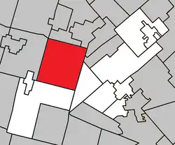 Location within Les Pays-d'en-Haut RCM | |
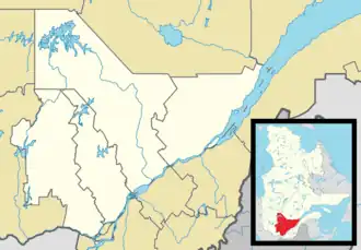 St-Adolphe -d'Howard Location in central Quebec | |
| Coordinates: 45°58′N 74°20′W / 45.97°N 74.33°W[1] | |
| Country | |
| Province | |
| Region | Laurentides |
| RCM | Les Pays-d'en-Haut |
| Settled | 1860s |
| Constituted | January 1, 1883 |
| Government | |
| • Mayor | Claude Charbonneau |
| • Fed. riding | Argenteuil—La Petite-Nation |
| • Prov. riding | Argenteuil |
| Area | |
• Total | 149.04 km2 (57.54 sq mi) |
| • Land | 135.80 km2 (52.43 sq mi) |
| Population (2021)[3] | |
• Total | 3,824 |
| • Density | 28.2/km2 (73/sq mi) |
| • Pop (2016–21) | |
| Time zone | UTC−5 (EST) |
| • Summer (DST) | UTC−4 (EDT) |
| Postal code | |
| Area code(s) | 819 |
| Website | www |
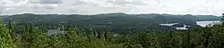
Saint-Adolphe-d'Howard (French pronunciation: [sɛ̃t‿adɔlf dawɚd, -wœʁd]) is a municipality in the Laurentian Mountains, in the Province of Quebec, Canada, north-west of Montreal.
Saint-Adolphe-d'Howard, located on the shores of lake Saint-Joseph, has nearly 70 lakes in its territory.[1] It is home to Mont-Avalanche ski resort.
History
Settlement began in 1864. In 1873, the geographic township of Howard was created, named after Frederick Howard, 5th Earl of Carlisle. The Lac-Saint-Joseph Mission was founded in 1878, served by Adolphe Jodoin (1836-1891), parish priest of Saint-Sauveur-des-Monts. In 1882, the Saint-Adolphe-de-Howard post office opened. The following year, the Township Municipality of Howard was established.[1]
In 1939, the township changed name and statutes to become the Municipality of Saint-Adolphe-d'Howard.[1]
From 1952 to 1987, Saint-Adolphe-d'Howard was home to Canadian Forces Station Lac St. Denis.[1]
Demographics
|
|
| ||||||||||||||||||||||||||||||||||||||||||||||||||||||||||||||||||||||||||||||
| Source: Statistics Canada[3][4][5][6] | ||||||||||||||||||||||||||||||||||||||||||||||||||||||||||||||||||||||||||||||||
Private dwellings occupied by usual residents (2021): 2,039 (total dwellings: 3,730)[3]
Mother tongue (2021):[3]
- English as first language: 7.7%
- French as first language: 87.2%
- English and French as first languages: 1.2%
- Other as first language: 3.4%
Government
List of former mayors:[7]
- Gédéon Ouimet (1883–1890)
- Charles Brunet (1890–1905)
- Adélard Gratton (1905–1910)
- Olivier Wood (1910–1913)
- Victor Bergeron (1913–1919)
- Dosithée Forget (1919–1922)
- Ferdinand Depatie (1922–1925)
- Cyrille Guindon (1925–1932)
- Henri Lajeunesse (1932–1937)
- Albert Bertrand (1937–1945)
- Wilfrid Gratton (1945–1951, 1955–1959)
- Édouard Bellefleur (1951–1955)
- Émile Gratton (1959–1962)
- D. E. Ross (1962–1963)
- J. A. Préfontaine (1963–1965, 1968–1969)
- Charles Brosseau (1965–1967)
- Henri Paul Potvin (1967–1968)
- Gaston R. Bourgeault (1969–1973)
- Marcel Godin (1973–1981, 1982–1985)
- Albert Di Fruscia (1981–1982)
- Michel Gratton (1985–1993)
- Jean J. Brossard (1993–2004)
- Marc Vadeboncoeur (2004–2005)
- Pierre Roy (2005–2009)
- Réjean Gravel (2009–2013)
- Lisette Lapointe (2013–2017)
- Claude Charbonneau (2017–present)
Education
Sir Wilfrid Laurier School Board operates Anglophone public schools:
- Sainte Agathe Academy in Sainte-Agathe-des-Monts serves the northern portion for both elementary and secondary levels.[8]
- Morin Heights Elementary School (serves the southern portion) in Morin-Heights[9]
- Laurentian Regional High School (serves the southern portion) in Lachute[10]
See also
References
- ^ a b c d e "Banque de noms de lieux du Québec: Reference number 55494". toponymie.gouv.qc.ca (in French). Commission de toponymie du Québec.
- ^ a b "Répertoire des municipalités: Geographic code 77065". www.mamh.gouv.qc.ca (in French). Ministère des Affaires municipales et de l'Habitation.
- ^ a b c d e "Saint-Adolphe-d'Howard (Code 2477065) Census Profile". 2021 census. Government of Canada - Statistics Canada. Retrieved 2025-08-20.
- ^ 1996, 2001, 2006, 2011 census
- ^ Eighth Census of Canada 1941 - Volume II - Population by Local Subdivisions (Report). Dominion Bureau of Statistics. 1944. CS98-1941-2.
- ^ "1971 Census of Canada - Population Census Subdivisions (Historical)". Catalogue 92-702 Vol I, part 1 (Bulletin 1.1-2). Statistics Canada. July 1973.
- ^ "Répertoire des entités géopolitiques: Saint-Adolphe-d'Howard (municipalité) 1.1.1883 - ..." www.mairesduquebec.com. Institut généalogique Drouin. Retrieved 20 August 2025.
- ^ "About Us." Saint Agathe Academy. Retrieved on September 4, 2017. See Elementary zone map Archived 2017-09-04 at the Wayback Machine and Secondary zone map Archived 2017-09-04 at the Wayback Machine - Note that all areas covered in the elementary map are also covered in the secondary one.
- ^ "MORIN HEIGHTS ELEMENTARY ZONE Archived 2017-09-16 at the Wayback Machine." Sir Wilfrid Laurier School Board. Retrieved on September 16, 2017.
- ^ "LAURENTIAN REGIONAL HS ZONE Archived 2010-12-14 at the Wayback Machine." Sir Wilfrid Laurier School Board. Retrieved on September 4, 2017.
External links
- Official site of Saint-Adolphe-d'Howard
- st-adolphe.info (Local news, information, and community agenda)
- Pays-d'en-Haut CLD (Local Development Centre)
- (in French) Avalanche Culture Plein Air (Ski and Sports Station)
- (in French) Association des sports nautiques de Saint-Adolphe-d'Howard (Local Association)
Adjacent Municipal Subdivisions | ||||||||||||||||
|---|---|---|---|---|---|---|---|---|---|---|---|---|---|---|---|---|
| ||||||||||||||||
| Towns | |
|---|---|
| Municipalities | |
| Parishes | |
| |