Russarö
Russarö is an island south of Hanko. The island is closed to the public as it is military area of the Finnish Defence Forces. The island hosts the five-story Russarö Lighthouse built in 1863[1][2] and a Finnish Meteorological Institute weather station.[3]
December 1939
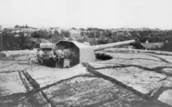
On 1 December 1939, the Soviet light cruiser Kirov, accompanied by the destroyers Stremitelny and Smetlivy, approached the fortified coastal artillery battery located on the island. After a short exchange of fire, Stremitelny and Kirov were hit and the ships withdrew. Aboard the Kirov, 17 men were killed and 30 wounded.
Climate
| Climate data for Hanko Russarö (1991-2020 normals, extremes 1959- present) | |||||||||||||
|---|---|---|---|---|---|---|---|---|---|---|---|---|---|
| Month | Jan | Feb | Mar | Apr | May | Jun | Jul | Aug | Sep | Oct | Nov | Dec | Year |
| Record high °C (°F) | 7.6 (45.7) |
7.8 (46.0) |
10.2 (50.4) |
17.7 (63.9) |
26.5 (79.7) |
28.2 (82.8) |
30.5 (86.9) |
27.7 (81.9) |
22.9 (73.2) |
16.3 (61.3) |
12.9 (55.2) |
9.6 (49.3) |
30.5 (86.9) |
| Mean maximum °C (°F) | 4.8 (40.6) |
3.7 (38.7) |
5.9 (42.6) |
11.6 (52.9) |
18.8 (65.8) |
21.9 (71.4) |
25.0 (77.0) |
23.7 (74.7) |
19.4 (66.9) |
14.2 (57.6) |
9.6 (49.3) |
6.4 (43.5) |
25.9 (78.6) |
| Mean daily maximum °C (°F) | 0.6 (33.1) |
−0.5 (31.1) |
1.7 (35.1) |
5.9 (42.6) |
11.6 (52.9) |
16.4 (61.5) |
20.3 (68.5) |
19.8 (67.6) |
15.5 (59.9) |
9.8 (49.6) |
5.5 (41.9) |
2.7 (36.9) |
9.1 (48.4) |
| Daily mean °C (°F) | −1.3 (29.7) |
−2.6 (27.3) |
−0.5 (31.1) |
3.2 (37.8) |
8.5 (47.3) |
13.4 (56.1) |
17.4 (63.3) |
17.2 (63.0) |
13.2 (55.8) |
8.0 (46.4) |
3.9 (39.0) |
1.1 (34.0) |
6.8 (44.2) |
| Mean daily minimum °C (°F) | −3.3 (26.1) |
−4.6 (23.7) |
−2.7 (27.1) |
1.1 (34.0) |
5.9 (42.6) |
11.1 (52.0) |
15.0 (59.0) |
14.9 (58.8) |
11.2 (52.2) |
6.2 (43.2) |
2.2 (36.0) |
−0.9 (30.4) |
4.7 (40.4) |
| Mean minimum °C (°F) | −13.0 (8.6) |
−13.3 (8.1) |
−9.4 (15.1) |
−3.0 (26.6) |
1.5 (34.7) |
7.0 (44.6) |
11.0 (51.8) |
10.7 (51.3) |
5.9 (42.6) |
−0.4 (31.3) |
−4.1 (24.6) |
−8.5 (16.7) |
−15.9 (3.4) |
| Record low °C (°F) | −33.6 (−28.5) |
−30.6 (−23.1) |
−21.2 (−6.2) |
−13.6 (7.5) |
−2.6 (27.3) |
3.7 (38.7) |
8.2 (46.8) |
6.0 (42.8) |
1.0 (33.8) |
−6.7 (19.9) |
−15.0 (5.0) |
−27.3 (−17.1) |
−33.6 (−28.5) |
| Source 1: FMI normals 1991-2020[4] | |||||||||||||
| Source 2: Record highs and lows[5] | |||||||||||||
References
- ^ Majakkamestarit ry: Russarö (in Finnish)
- ^ The Finnish Maritime Administration: Russarö (in Finnish)
- ^ Finnish Meteorological Institute: Paikallissään asemakuvaukset (in Finnish)
- ^ "FMI normals 1991-2020". FMI. Retrieved 15 May 2025.
- ^ "FMI open data". FMI. Retrieved May 15, 2025.
External links
59°46′19″N 22°56′50″E / 59.77194°N 22.94722°E