Rosslyn, Virginia
Rosslyn | |
|---|---|
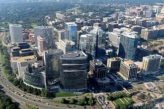 An aerial view of Rosslyn in September 2018 | |
| Country | |
| State | |
| County | |
| Population (2010) | |
• Total | 12,314 |
| Time zone | UTC-5 (EST) |
| • Summer (DST) | UTC-4 (EDT) |
| ZIP Codes | 22209 |
| Area code | 703 |
| Website | www.rosslynva.org |
Rosslyn (/ˈrɒzlɪn/ ROZ-lin) is a heavily urbanized unincorporated area in northeastern Arlington County, Virginia, United States. It is in Northern Virginia, north of Arlington National Cemetery and directly across the Potomac River from Georgetown and Foggy Bottom in Washington, D.C.
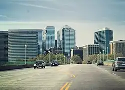
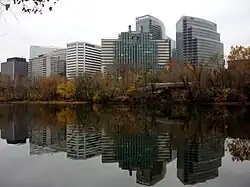
Rosslyn encompasses the Arlington neighborhoods of North Rosslyn and Radnor/Ft. Myer Heights, and is located east of Court House, another urbanized Arlington neighborhood. Characterized as one of several "urban villages" by the county, the numerous skyscrapers in the dense business section of Rosslyn make its appearance in some ways more urban than nearby Washington. Rosslyn residents have an average household income of $105,000 and 81% are college graduates.[1]
Establishments in the neighborhood include Sinclair Broadcast Group-owned ABC affiliate WJLA located in the Rosslyn Twin Towers, and Marriott International's longest operating hotel, the former Key Bridge Marriott. Notable structures include the United States Marine Corps War Memorial, and the Netherlands Carillon and Freedom Park offer views of the Washington Monument and other Washington landmarks.
History
Colonial era and early history
Part of the Lords Fairfax's Northern Neck Proprietary during the colonial era, much of present-day Rosslyn was included Thomas Owsley's 640-acre land grant in the 1690s.[2] Landowner Francis Awbrey purchased land along the Potomac River shoreline near Theodore Roosevelt Island, then known by various names including Analostan Island, in 1733 and established a ferry that provided service to the mouth of Rock Creek after 1738; he also operated a tavern nearby.[3] Awbrey's descendants eventually sold the property to George Mason in 1767, who also ran a ferry between Georgetown and Analostan Island. Mason bequeathed this land to his son John in 1792, who thereafter built a summer residence on Analostan Island and attempted to establish a town named South Haven where Rosslyn now stands; this venture was ultimately unsuccessful and only a few homes were built near the Mason's ferry.[3]
John Mason eventually lost his properties in the 1830s after a series of business failures.[4] His creditor, the Bank of the United States, took possession of Mason's holdings in the Rosslyn area and began selling them off starting in 1836.[3] By 1860, several families, including the Dawsons, Birches, and Rosses, had farms in the area, which they operated with enslaved labor.[5][6][7] The Ross farm, which William H Ross established on August 1, 1860 after being gifted land following his marriage to his wife Carolyn, was called "Ross Lynn"; this was eventually shortened to "Rosslyn".[7]
Civil War and early development
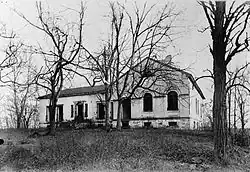
.JPG)
The Alexandria Canal, which connected Alexandria with Georgetown's Chesapeake and Ohio Canal via the Aqueduct Bridge completed in 1843, ran through present-day Rosslyn along the Potomac River.[8] The Rosslyn area's location at the foot of the bridge rendered it a strategically important bridgehead during the Civil War, which was crossed by Major Wood and his unit in May 1861 as a part of the Union army's occupation of Alexandria County. Several forts, including Fort Corcoran, Fort Bennett, and Fort Haggarty, were constructed near the Aqueduct Bridge as a part of the Union's Arlington Line of defenses.[9] The bridge itself was drained during the course of the war and used as a roadway for troops and supplies.[10] Additionally, Analostan Island was the site of the Union's Camp Greene, where the 1st U.S. Colored Infantry Regiment were first mustered in May 1863;[11] after troops left the camp in April 1864, the installation served as a contraband camp for hundreds of formerly enslaved refugees from the South.[12] The area was first designated as "Rosslyn", after the Ross's farm, in an 1865 map of the Union's defenses of Washington.[13]

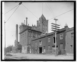
In 1869, a group of investors acquired the Rosslyn farm and other properties and attempted to develop the "Town of Rosslyn".[14] While this ultimately failed like John Mason's earlier attempt,[14] the continued presence of soldiers at Fort Whipple, later renamed Fort Myer in 1881, in the immediate aftermath of the Civil War as well as Rosslyn's proximity to the Aqueduct Bridge, which was converted to a two-tier bridge in 1868 that supported both canal and foot traffic, enabled the development of gambling houses, saloons, and brothels by the 1870s.[13][15][16] The Consumer Brewery, which was established 1896 and housed in a plant designed by architect Albert Goenner, supplied these establishments with local beer.[17] A ravine near the community nicknamed Dead Man's Hollow became the focus of media attention throughout the rest of the 19th and into the early 20th centuries as the location of assaults, murders, and other crimes.[13] Rosslyn also became home to a black enclave during this period and was notable for being an interracial neighborhood in Arlington at a time when the county became increasingly racially segregated in the post-Reconstruction era.[18]
1900 through 1950

Rosslyn's criminal activity, nightlife, and status as an interracial neighborhood made it the focus of Arlington's Southern Progressive reformers by the early 20th century.[16] These figures, who included attorney Crandal Mackey and developer Frank Lyon, had organized the Good Citizen's League in the 1890s to eradicate Arlington's "areas of vice" in order to facilitate Arlington's growing suburbanization driven by its expanding interurban trolley network.[19] Consistent with Southern Progressive objectives, the League sought to achieve this while maintaining Arlington's racial hierarchy and segregation of its black residents.[19] This culminated in the violent raiding of several saloons and gambling halls by Mackey and other League members on May 30, 1904.[20] Rosslyn's casinos and brothels continued to operate into the 1920s, with some located on floating barges underneath the Key Bridge and along Rosslyn's waterfront; these business were later cleared during the construction of the George Washington Memorial Parkway.[14] Prohibition led to the conversion of Rosslyn's Consumer Brewery, which had earlier been renamed Arlington Brewery, into a Cherry Smash soda bottling plant in 1920.[21]

From the late 19th century, Rosslyn was a central node in Arlington's electric trolley system, with the Great Falls & Old Dominion Railway providing service between Rosslyn and Great Falls beginning in 1906 and the Washington, Arlington, and Falls Church Railway (W-V) providing service out to Green Valley, Fairfax Court House, and Arlington Junction; service continued to expand after the formation of the Washington & Old Dominion Railway (W&OD) in 1912.[22] After the Aqueduct Bridge was demolished and replaced by the Key Bridge in 1923, the Capital Traction Company was able to displace W&OD service to Washington, which the W&OD connected to with a new Rosslyn Terminal station.[23] Financial difficulties experienced by the railroad companies during the Great Depression, rising car ownership, and highway construction resulted in the end of passenger rail service in Rosslyn and elsewhere in Arlington by the 1930s.[24] The subsequent conversion of Arlington's passenger railways into freight services resulted in Rosslyn becoming the location for rail yards and industrial storage facilities.[14]
1960s redevelopment through present
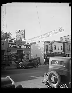
By the mid 20th century, Rosslyn was characterized by industrial infrastructure, pawnshops, and vacant lots.[25][26] Described by Arlington's planning board as having a "general appearance [that] brings no credit whatsoever to the county" in 1957,[14] Arlington's county government sought to transform Rosslyn into a high-rise district to attract more commercial businesses and reduce its economic reliance on the federal government, for which it had been dependent on for much of its tax revenue since World War II.[26][27] The General Land Use Plan (GULP) adopted by Arlington in 1961 rezoned Rosslyn for commercial use, which guided by the county's Rosslyn Plan enabled developers to rapidly erect skyscrapers; 19 of these were built between 1962 and 1967.[26] Former landmarks, including the Arlington Brewery in 1958, were cleared over the next few decades to make way for office, hotel, and highway construction.[14] Government agencies and contractors became one of the largest share of office tenants as Rosslyn emerged as a central business district.[28]
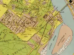
.jpg)
Following the Arlington county board's success in securing the placement of the anticipated Washington Metro Orange Line from Rosslyn to Ballston, Rosslyn and its adjacent neighborhoods were arranged as urban villages with distinct identities as a part of its "Bull's Eye" planning model, where high-density development would be restricted within a specific radius from Metro stations. Rosslyn was designated as a business district within this vision. Rosslyn's Metro station, which opened in 1979, was designed as a junction between the Orange and Blue lines, the latter of which opened in 1977 with service towards the Pentagon and Alexandria.[29]
Between October 1972 and November 1973, Washington Post journalist Bob Woodward met with Deputy Director of the Federal Bureau of Investigation and whistleblower Mark Felt, at the time code-named "Deep Throat", in a Rosslyn parking garage to exchange classified information about the June 1972 break-in of the Democratic Party's offices at the Watergate Complex in Washington.[30] Woodward and fellow reporter Carl Bernstein's subsequent investigation and reporting eventually led to the Watergate Scandal and President Richard Nixon's resignation in 1974.[30] Since 2011, this has been commemorated with a historic plaque on North Nash Street.[31]
The concentration of Rosslyn's initial development efforts on commercial properties eventually concerned county planners, as the neighborhood often described as a "ghost town" outside of business hours given the lack of apartments. Successive urban plans of Rosslyn from the 1970s envisioned a greater level of residential space, a gradual replacement of the area's first generation of skyscrapers with more attractive architecture, and green space.[25] This reorientation of Rosslyn towards mixed-use development has continued into the 21st century, which has seen many of its original skyscrapers replaced with newer office buildings, apartments, condos, and hotels.[25] Rosslyn's skywalks, which were installed in the 1960s and were originally intended to separate pedestrians from vehicular traffic, have gradually been demolished as a part of this redevelopment to encourage greater walkability.[32] This period has seen several multinational corporations, including Nestlé in 2017 and CoStar Group in 2024, establishing corporate headquarters in Rosslyn's business district.[33][34]
Economy
_at_1800_North_Nash_Street_November_2013.jpg)
The original corporate headquarters of USA Today, owned by the Gannett Company, was located in Rosslyn. Both the company and the newspaper occupied two high-rise silver-colored towers, built in the early 1980s, which adjoin each other at 1000 and 1100 Wilson Boulevard. Gannett did not own these buildings, and moved from their original home to a new campus in Fairfax County, Virginia, in 2002. In the same year, the ABC-affiliate in Washington, D.C., WJLA-TV, "ABC 7", moved their main studios into the space in Rosslyn previously occupied by USA Today.[36]
Federal agencies based in Rosslyn include the U.S. Trade and Development Agency, the Bureau of Overseas Buildings Operations, the Bureau of Conflict and Stabilization Operations, and the Bureau of Diplomatic Security. The Department of State has several office locations in Rosslyn.
Nonprofits based in Rosslyn include the American Institute in Taiwan.
As of 2010, Rosslyn has 8.1 million square feet (750,000 m2) of office space and 6,365 housing units.[37] Some of the tallest condominium buildings in the Washington metropolitan area are located in Rosslyn. In particular, the Waterview and Turnberry Tower.[38]
Construction of 1812 N Moore in Rosslyn began in 2010, and in late 2013 it became the tallest building in the Washington metropolitan area.[39] In 2017, the international food and beverage company Nestlé S.A. announced that it would move its U.S. corporate headquarters from California to this building.
In order to make the area more walkable, Rosslyn's elevated walkways and other urban peculiarities are planned to be demolished or modified, along with lanes being removed or reversed.
Arts and culture

Annual cultural events
The Arlington County Government operates the 367-seat Rosslyn Spectrum Theater.[40][41] Five annual film festivals are held in Rosslyn. The Washington D.C. Independent Film Festival runs for nearly two weeks in March showing independent films from around the world in various locations in and around Washington, DC. In 2011 Rosslyn hosted over 30 film screenings as well as classes, seminars and workshops led by industry professionals.[42][43]
The Annual NoVa International Jewish Film Festival is held each spring in Rosslyn and other Virginia locations.[44] The Rosslyn Outdoor Film Festival runs in the spring and summer months showing popular films for free in Gateway Park Friday evenings at dusk.[45] Slapsticon is a four-day film festival in July that features silent films, occasionally accompanied by live musicians, as well as early films with audio tracks.[46] The Rosebud Film & Video Festival is an all day event in November that features original works by regional film and video makers.[47] The Rosslyn Jazz Festival, started in 1991, attracted 10,000 attendees in 2006.[48] The annual US FreedomWalk Festival, started in 2000, draws walkers from around the world each Fall for a weekend of walks in Rosslyn and nearby areas.[49]
Education
Rosslyn is part of Arlington Public School, the public school district for Arlington County, Virginia.
The Art Institute of Washington is located at North Fort Myer Drive. Rosslyn is a location for some of the University of Virginia's business programs, including McIntire School of Commerce Master of Science in the Management of Information Technology at the Waterview Conference Center, and Darden School of Business Master of Business Administration's Executive/Global Executive at the Rosslyn Twin Towers.
Museums and other points of interest
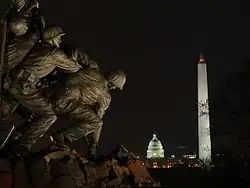
The Marine Corps War Memorial in Rosslyn is visited by over one million annually.[50] Among these visitors are audiences for the Sunset Parades performed Tuesday evenings during the summer months by the United States Marine Drum and Bugle Corps with the Marine Corps Silent Drill Platoon.[51] Crowds also gather at the Memorial on the 4th of July to watch the national fireworks display.[52]
The Netherlands Carillon in Rosslyn is a set of 50 bells housed in a 12-story tower between Arlington National Cemetery and the Marine Corps War Memorial. The carillon is a gift from the Netherlands to the US in recognition of support received during World War II. Originally installed with 49 bells, a 50th was added by the Netherlands in 1995 on the 50th anniversary of the liberation of the Netherlands. Each spring the grounds are planted with thousands of tulips imported from the Netherlands. During the summer months carilloneurs play concerts on the bells using a keyboard located in the tower. The tower is occasionally open to the public and offers views of the national monuments in Washington, DC, the Marine Corps War Memorial, and Arlington National Cemetery.[53]
Infrastructure
Transportation
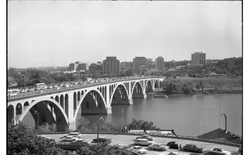
Rosslyn is a transportation hub for the subway and highway systems. It contains the intersection of U.S. Route 29 (Frances Scott Key Bridge and Lee Highway), Virginia State Route 110 (Richmond Highway), the George Washington Memorial Parkway, and I-66 (Custis Memorial Parkway). U.S. Route 50 (Arlington Boulevard) connects with all of these routes in and near Rosslyn. Washington Metro's Blue, Orange, and Silver Lines service the Rosslyn Metro station.[55]
There are 14 Metrobus lines to the urban village. There is a shuttle run by Georgetown University.[56] A DC Circulator route connected Rosslyn with Georgetown and Dupont Circle in Washington, D.C. until Circulator service discontinued in 2025 [57] There are 2 private bus companies that provide service between the Rosslyn Metro Station and New York City. Vamoose Bus provides daily service from 1801 N Lynn Street in Rosslyn to Penn Station/Madison Square Garden in Midtown Manhattan in New York City. Tripper Bus provides daily service from 1901 N. Moore Street to the Macy's flagship store on 34th Street in New York City.[58]
Trails
Multiple cycling and pedestrian trails are present in Rosslyn, connecting Northern Virginia and Washington, D.C. The paved Custis Trail travels through Rosslyn along Interstate 66. By traveling southeast on the Custis Trail and crossing the George Washington Memorial Parkway, one can reach the paved Mount Vernon Trail, which travels downstream on the Virginia side of the Potomac River to Alexandria and Mount Vernon, as well as the unpaved Potomac Heritage Trail, which travels upstream near the riverbank to the Capital Beltway. By heading west along the Custis Trail, one can reach the Washington and Old Dominion Railroad Trail, which travels for 45 miles (72 km) through Northern Virginia. One can also cross the Francis Scott Key Bridge at the end of Lynn Street and pick up the unpaved C&O Canal towpath or the paved Capital Crescent Trail in Washington. By heading south on North Lynn Street, one can cross over U.S. Route 50 and travel through the grounds of the Marine Corps War Memorial to reach a paved trail that travels along the wall of Arlington National Cemetery to Memorial Drive. A sidewalk and paved path along the Drive connects in Lady Bird Johnson Park on Columbia Island to the Mount Vernon Trail and to the wide sidewalk of the Arlington Memorial Bridge, which crosses the Potomac into Washington.
In popular culture
The following media feature Rosslyn in some way, usually by showing its distinctive skyline.
Movies
- All the President's Men (1976)
- True Lies (1994)
- Minority Report (2002)
- Mission: Impossible III[59] (2006)
- Transformers: Revenge of the Fallen (2009)
- Captain America: The Winter Soldier[60] (2014)
Music
- Rosslyn Mountain Boys (1977)
Television
- The West Wing (1999–2006)
- Bones (2005–2017)
- House of Cards (2013–2018)
- The Walking Dead (2016)
References
- ^ "Rosslyn By-The-Numbers". rosslynva.org.
- ^ Wise, Donald A. (October 1973). "Early Land Grants in Arlington, Virginia" (PDF). Arlington Historical Magazine. 5 (1): 29. Retrieved 13 August 2025.
- ^ a b c Abbott, Dorthea (October 1986). "The Roots of Clarendon" (PDF). Arlington Historical Magazine. 8: 48–49. Retrieved 19 August 2025.
- ^ Webb, Willard J. (October 1976). "John Mason of Analostan Island" (PDF). Arlington Historical Magazine. 5 (4): 34. Retrieved 13 August 2025.
- ^ "Thomas B. Dawson". enslavedarl.org. Arlington Historical Society. Retrieved 13 August 2025.
- ^ Eisenfeld, Sue. "Esther - Owned by three generations of enslavers and eventually freed". enslavedarl.org. Arlington Historical Society. Retrieved 13 August 2025.
- ^ a b Kaplan, Jessica. "Hired To Advantage: Hiring and the Enslaved People of Arlington". enslavedarl.org. Arlington Historical Society. Retrieved 13 August 2025.
- ^ Morgan, Maxine Goff (October 1966). "A Chronological History of the Alexandria Canal (Part II)" (PDF). Arlington Historical Magazine. 3 (2): 8, 23. Retrieved 13 August 2025.
- ^ Rose Jr., C. B. (October 1960). "Civil War Forts in Arlington" (PDF). Arlington Historical Magazine. 1 (4): 14–15. Retrieved 13 August 2025.
- ^ "A Forgotten Connection". canaltrust.org. C&O Canal Trust. Retrieved 13 August 2025.
- ^ "Camp Greene". nps.gov. National Park Service. Retrieved 19 August 2025.
- ^ "Freedman's Camp". nps.gov. National Park Service. Retrieved 19 August 2025.
- ^ a b c Hollmuller, Anne (9 May 2018). ""And Other Bloody Happenings": Rosslyn and the Dangers of Dead Man's Hollow". WETA. Retrieved 13 August 2025.
- ^ a b c d e f Hogan, Bill (October 1982). "The Men Who Made Rosslyn". Regardie's. Retrieved 14 August 2025.
- ^ "The Aqueduct Bridge". library.arlingtonva.us. Arlington Public Library. Retrieved 13 August 2025.
- ^ a b Bestebreurtje 2024, p. 70
- ^ "The Consumer Brewery". library.arlingtonva.us. Arlington Public Library. Retrieved 13 August 2025.
- ^ Bestebreurtje 2024, p. 72
- ^ a b Bestebreurtje 2024, p. 67
- ^ Bestebreurtje 2024, pp. 70–73
- ^ Center for Local History. "Arlington Brewing Company". arlingtonhistorical.com. Arlington Historical Society. Retrieved 14 August 2025.
- ^ Tennyson 1984, pp. 40–41
- ^ Tennyson 1984, p. 44
- ^ Tennyson 1984, pp. 44–45
- ^ a b c Jarvis, James (1 September 2023). "From rail yards to residential towers: Rosslyn's half-century transformation". ArlNow. Retrieved 14 August 2025.
- ^ a b c Deines 1995, p. 61
- ^ Deines 1995, p. 55
- ^ County of Arlington, Virginia (July 2015). Rosslyn Sector Plan (PDF). Arlington, Virginia: Arlington County Department of Community Planning, Housing and Development, Planning Division. p. 15.
- ^ Craft, Kevin (28 October 2013). "When the Metro Came to Town". Arlington Magazine. Retrieved 14 August 2025.
- ^ a b Jenkins, Nash (16 June 2014). "The Garage Where 'Deep Throat' Spilled Watergate Secrets Will Be Demolished". Time. Retrieved 19 August 2025.
- ^ "Appendix 1: Arlington County Historical Markers" (PDF). arlingtonva.us. County of Arlington, Virginia. Retrieved 19 August 2025.
- ^ DeVoe, Joe (18 January 2024). "A mid-century relic of Rosslyn's pedestrian infrastructure, next to the church-gas station, is coming down this summer". ArlNow. Retrieved 19 August 2025.
- ^ "Nestlé USA Chooses Arlington, Virginia as New U.S. Headquarters". arlingtonva.us. County of Arlington, Virginia. Retrieved 19 August 2025.
- ^ "Real Estate Giant CoStar Group Chooses Arlington for its Headquarters". arlingtonva.us. County of Arlington, Virginia. Retrieved 19 August 2025.
- ^ "Northern Virginia skyscraper rivalry has a new leader: Fairfax approves 470' Capital One tower". Beyonddc.com. 20 May 2014. Retrieved 25 June 2018.
- ^ Lohr, Greg (16 April 2001). "Channel 7 tunes in to former Gannett digs in Rosslyn". Washington Business Journal. Retrieved 5 August 2011.
- ^ Building A Skyline Archived 18 August 2013 at the Wayback Machine
- ^ Fleishman, Sandra (4 March 2006). "Coming to Rosslyn, The Height of Luxury". The Washington Post. Retrieved 24 February 2011.
- ^ "1812 N. Moore tower crane becomes region's second-tallest structure - Washington Business Journal". Archived from the original on 23 June 2013.
- ^ "Event Calendar - Washington Post - Washington, DC". The Washington Post. Retrieved 25 June 2018.
- ^ Play | Rosslyn BID Archived 29 September 2011 at the Wayback Machine. Rosslynva.org. Retrieved on 2013-08-12.
- ^ "Repertory". The Washington Post. 4 March 2011.
- ^ Movie Tickets: What to See Beyond the Multiplex | Film. Washingtonian (1 March 2011). Retrieved on 2013-08-12.
- ^ "Error-2010-f3". Retrieved 25 June 2018.
- ^ "I Love the '90s Rosslyn Outdoor Film Festival". The Washington Post. Archived from the original on 29 June 2011.
- ^ [1] Archived 3 April 2012 at the Wayback Machine
- ^ [2] Archived 10 July 2011 at the Wayback Machine
- ^ Rosslyn Jazz Festival 07. Allaboutjazz.com. Retrieved on 2013-08-12.
- ^ [3] Archived 3 September 2010 at the Wayback Machine
- ^ http://www.iwojimaassociation.org/docs/IJAANewsletter2010Fall.pdf
- ^ [4] Archived 29 August 2010 at the Wayback Machine
- ^ Spectacular views of the national fireworks from Arlington : County Manager : Arlington, Virginia. Arlingtonva.us. Retrieved on 2013-08-12.
- ^ "Netherlands Carillon". The Washington Post. Archived from the original on 7 January 2016.
- ^ "Quick Study of Alexandria, Arlington". The Washington Post. 22 April 2004. Archived from the original on 31 January 2013. Retrieved 13 April 2012.
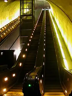
The Rosslyn Metro station features the third longest continuous escalator in the world (194 feet 8 inches).
- ^ Scott Tyson, Ann (9 July 2010). "Metro has new plan to ease Orange and Blue line congestion at Rosslyn station". The Washington Post. Retrieved 11 May 2012.
- ^ Georgetown University Transportation Shuttle (GUTS). Otm.georgetown.edu. Retrieved on 2013-08-12.
- ^ "DC Circulator Expansion Continues". DDOT. Archived from the original on 29 October 2010. Retrieved 30 August 2010.
- ^ Sottili, Carol; Scott Vogel; Christina Talcott (15 February 2009). "Coming and Going: $1 Buses to NYC". The Washington Post. Retrieved 13 April 2012.
- ^ "5 Movies Filmed in NoVA". Northern Virginia Magazine. Archived from the original on 20 May 2013.
- ^ "Rosslyn Gets a Cameo in 'Captain America'". ARLnow.com.
Bibliography
- Bestebreurtje, Lindsey (2024). Built by the People Themselves: African American Community Development in Arlington, Virginia, from the Civil War through Civil Rights. Columbia: The University of South Carolina Press. ISBN 978-1-64336-498-8.
- Deines, Ann (October 1995). "A Survey of the Development of Arlington County, Virginia, 1940 - 1965" (PDF). Arlington Historical Magazine. 10 (3). Retrieved 19 August 2025.
- Tennyson, E. L. (October 1984). "The History of Arlington County's Electric Railways" (PDF). Arlington Historical Magazine. 7 (4): 39–48. Retrieved 19 August 2025.
External links
- Rosslyn Metro Station Area Data, Statistics and Development Profile Archived 14 February 2014 at the Wayback Machine
- Arlington's Urban Villages - Rosslyn
- Rosslyn: Discover a New Horizon
- Rosslyn walking map and guide
- Urban Arlington County
- Discover Rosslyn: Restaurants, Shopping and Living
- Rosslyn City: the Brooklyn of Washington City - 1889 advertisement from The Washington Post
Municipalities and communities of Arlington County, Virginia, United States | ||
|---|---|---|
| Unincorporated communities |
|  |