Riverside Park, Ottawa
Riverside Park is a neighbourhood in the south end of Ottawa, Canada.
Riverside Park | |
|---|---|
Neighbourhood | |
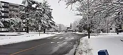 Looking South on Springland Dr | |
| Country | Canada |
| Province | Ontario |
| City | Ottawa |
| Government | |
| • MPs | David McGuinty |
| • MPPs | John Fraser |
| • Community association | Riverside Park Community Association |
| Population (2011) | |
• Total | 7,457 |
| • Density | 2,194/km2 (5,680/sq mi) |
| Time zone | UTC-5 (Eastern (EST)) |
| Website | Official website |
History
It is bounded on the north by Brookfield Road, on the east by the Airport Parkway, on the south by the CN rail tracks and on the west by the Rideau River.
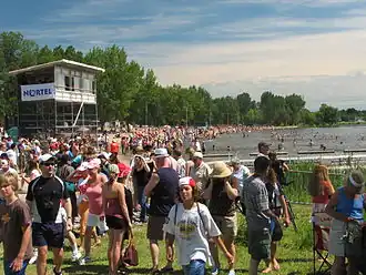
The neighbourhood includes one of Ottawa's most well known beaches at Mooney's Bay and the Terry Fox Athletic Facility. Confederation Heights sits at the northern tip of the neighbourhood. It also includes the Ottawa Hunt and Golf Club, which has hosted professional and amateur golf tournaments.
The neighbourhood is bifurcated by a Via Rail Corridor, once owned and operated by the OCRR.[1] The area west of it is known as Mooney's Bay and the area east of it is called General Vanier. The area to the south of Walkley Road is Divided into three, McCarthy Rd Separates Riverside East and Riverside West. The area in-between the Rideau River and Riverside Rd is know as Revelstoke .[2]
According to the Canada 2011 Census, the population of the neighbourhood north of Walkley (Census Tract 5050003.00) was 4564 and south of Walkley (Census Tract 5050002.01) was 2893 for a total of 7457.[3][4]
Parks
The Riverside community has a high park density, the area is served by thirteen parks;
Mooney's Bay
- Hog's Back Park (Located along Hog's Back Rd)
- Vincent Massey Park (Located at Heron Rd and Riverside Dr)
- Mooney's Bay Beach (Located along Riverside Dr)
- Paget Park, (Located at Hobson Rd and Garner Ave)
- Ernie Calcutt Park, (Located at Mooneys Bay Pl and Springland Dr)
- Marble Park, (Located at Marble cr and Flannery Dr)
- Flannery Park (Located at the Corner of Flannery Dr)
General Vanier
- Pauline Vanier Park (Located adjacent to General Vanier Public School)
Riverside West
- Otterson Park, (Located on Blanchard Cr)
- Arnott Park, (Located on Hartman Cr)
Riverside East
- Linton Park, (Located between the Airport Parkway and Linton Rd)
- Stanstead Park, (Located adjacent to École élémentaire catholique George-Étienne-Cartier)
Revelstroke
- Geoff Wightman Park (Located on the corner of Kamloops Ave)
School
The area is served by Brookfield High School, Fielding Dr Public School, General Vanier, Bayview Public School, Georges Étienne Cartier as well as the Holy Cross Catholic School.[5]
In August 2007, Bayview Public School was closed at its site on Riverside drive and later demolished in 2009.[6] Its French immersion program moved to the R. Byrns Curry Public School building (renamed Bayview Public School). R. Byrns Curry students were reassigned to General Vanier Public School (J-K to grade 3) and Fielding Drive Public School (grades 4 to 8).[7] The area on which the former school sat on has been a large spark of controversy after its demolition, the city was going to develop the property into a retirement homes. The issue came when the initial plan of low to medium density changed to high density despite its promise to the community.[8][9] After many years of push backs from the community construction has started on the lands.
References
- ^ "Railway Maintenance – Ottawa, ON" (PDF). Archived from the original (PDF) on 2015-07-27.
- ^ "Neighbourhood Map – RiversidePark.ca". Archived from the original on 2020-06-22. Retrieved 2025-08-08.
- ^ "Statistics Canada: 2011 Census Profile". 8 February 2012.
- ^ "Statistics Canada: 2011 Census Profile". 8 February 2012.
- ^ "Discover Ottawa's Riverside Park Neighborhood - Local Information & Real Estate". www.ottawamove.com. Retrieved 2025-08-08.
- ^ "Gloucester Historical Society". www.gloucesterhistory.com. Retrieved 2025-08-08.
- ^ "Facilitator's report for Bayview Public School" (PDF). OurDigitalWorld. Retrieved 9 June 2015.
- ^ "'Betrayed' Riverside Park community protests Bayview School development - Ottawa - CBC News". Archived from the original on 2017-11-02. Retrieved 2025-08-08.
- ^ "Tentative new owner of Bayview School site plans retirement community". ca.news.yahoo.com. 2017-03-08.
Places adjacent to Riverside Park, Ottawa | |
|---|---|
External links
45°22′04″N 75°41′00″W / 45.36778°N 75.68333°W