Ripponlea railway station
Ripponlea | ||||||||||||||||||||||||||||||||||||||||||||||||||||||||||||||||||||||
|---|---|---|---|---|---|---|---|---|---|---|---|---|---|---|---|---|---|---|---|---|---|---|---|---|---|---|---|---|---|---|---|---|---|---|---|---|---|---|---|---|---|---|---|---|---|---|---|---|---|---|---|---|---|---|---|---|---|---|---|---|---|---|---|---|---|---|---|---|---|---|
| PTV commuter rail station | ||||||||||||||||||||||||||||||||||||||||||||||||||||||||||||||||||||||
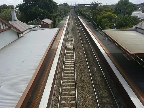 Ripponlea station, 2021 | ||||||||||||||||||||||||||||||||||||||||||||||||||||||||||||||||||||||
| General information | ||||||||||||||||||||||||||||||||||||||||||||||||||||||||||||||||||||||
| Location | Glen Eira Road, Ripponlea, Victoria 3185 City of Port Phillip Australia | |||||||||||||||||||||||||||||||||||||||||||||||||||||||||||||||||||||
| Coordinates | 37°52′33″S 144°59′42″E / 37.8759°S 144.9951°E | |||||||||||||||||||||||||||||||||||||||||||||||||||||||||||||||||||||
| Owned by | VicTrack | |||||||||||||||||||||||||||||||||||||||||||||||||||||||||||||||||||||
| Operated by | Metro Trains | |||||||||||||||||||||||||||||||||||||||||||||||||||||||||||||||||||||
| Line(s) | Sandringham | |||||||||||||||||||||||||||||||||||||||||||||||||||||||||||||||||||||
| Distance | 9.83 kilometres from Southern Cross | |||||||||||||||||||||||||||||||||||||||||||||||||||||||||||||||||||||
| Platforms | 2 side | |||||||||||||||||||||||||||||||||||||||||||||||||||||||||||||||||||||
| Tracks | 2 | |||||||||||||||||||||||||||||||||||||||||||||||||||||||||||||||||||||
| Connections |
| |||||||||||||||||||||||||||||||||||||||||||||||||||||||||||||||||||||
| Construction | ||||||||||||||||||||||||||||||||||||||||||||||||||||||||||||||||||||||
| Structure type | Ground | |||||||||||||||||||||||||||||||||||||||||||||||||||||||||||||||||||||
| Bicycle facilities | Yes | |||||||||||||||||||||||||||||||||||||||||||||||||||||||||||||||||||||
| Accessible | Yes—step free access | |||||||||||||||||||||||||||||||||||||||||||||||||||||||||||||||||||||
| Other information | ||||||||||||||||||||||||||||||||||||||||||||||||||||||||||||||||||||||
| Status | Operational, host station | |||||||||||||||||||||||||||||||||||||||||||||||||||||||||||||||||||||
| Station code | RIP | |||||||||||||||||||||||||||||||||||||||||||||||||||||||||||||||||||||
| Fare zone | Myki Zone 1 | |||||||||||||||||||||||||||||||||||||||||||||||||||||||||||||||||||||
| Website | Public Transport Victoria | |||||||||||||||||||||||||||||||||||||||||||||||||||||||||||||||||||||
| History | ||||||||||||||||||||||||||||||||||||||||||||||||||||||||||||||||||||||
| Opened | 1 May 1912 | |||||||||||||||||||||||||||||||||||||||||||||||||||||||||||||||||||||
| Electrified | 1500 V DC overhead (28 May 1919) | |||||||||||||||||||||||||||||||||||||||||||||||||||||||||||||||||||||
| Passengers | ||||||||||||||||||||||||||||||||||||||||||||||||||||||||||||||||||||||
| 2005–2006 | 544,171[1] | |||||||||||||||||||||||||||||||||||||||||||||||||||||||||||||||||||||
| 2006–2007 | 582,849[1] | |||||||||||||||||||||||||||||||||||||||||||||||||||||||||||||||||||||
| 2007–2008 | 614,903[1] | |||||||||||||||||||||||||||||||||||||||||||||||||||||||||||||||||||||
| 2008–2009 | 675,480[2] | |||||||||||||||||||||||||||||||||||||||||||||||||||||||||||||||||||||
| 2009–2010 | 718,704[2] | |||||||||||||||||||||||||||||||||||||||||||||||||||||||||||||||||||||
| 2010–2011 | 708,724[2] | |||||||||||||||||||||||||||||||||||||||||||||||||||||||||||||||||||||
| 2011–2012 | 659,004[2] | |||||||||||||||||||||||||||||||||||||||||||||||||||||||||||||||||||||
| 2012–2013 | Not measured[2] | |||||||||||||||||||||||||||||||||||||||||||||||||||||||||||||||||||||
| 2013–2014 | 727,060[2] | |||||||||||||||||||||||||||||||||||||||||||||||||||||||||||||||||||||
| 2014–2015 | 714,429[1] | |||||||||||||||||||||||||||||||||||||||||||||||||||||||||||||||||||||
| 2015–2016 | 788,960[2] | |||||||||||||||||||||||||||||||||||||||||||||||||||||||||||||||||||||
| 2016–2017 | 748,125[2] | |||||||||||||||||||||||||||||||||||||||||||||||||||||||||||||||||||||
| 2017–2018 | 747,752[2] | |||||||||||||||||||||||||||||||||||||||||||||||||||||||||||||||||||||
| 2018–2019 | 656,564[2] | |||||||||||||||||||||||||||||||||||||||||||||||||||||||||||||||||||||
| 2019–2020 | 531,200[2] | |||||||||||||||||||||||||||||||||||||||||||||||||||||||||||||||||||||
| 2020–2021 | 244,200[2] | |||||||||||||||||||||||||||||||||||||||||||||||||||||||||||||||||||||
| 2021–2022 | 276,600[3] | |||||||||||||||||||||||||||||||||||||||||||||||||||||||||||||||||||||
| Services | ||||||||||||||||||||||||||||||||||||||||||||||||||||||||||||||||||||||
| ||||||||||||||||||||||||||||||||||||||||||||||||||||||||||||||||||||||
| ||||||||||||||||||||||||||||||||||||||||||||||||||||||||||||||||||||||
| ||||||||||||||||||||||||||||||||||||||||||||||||||||||||||||||||||||||
Ripponlea railway station is a commuter railway station in Melbourne, Victoria, Australia. Opened on 1 May 1912, the station complex is listed on the Victorian Heritage Register.[4][5] The station is named after, and serves, the south-eastern suburb of Ripponlea. Ripponlea station is a ground level host station, featuring two side platforms.[4] The railway station is accessible, with step free access provided.[6]
Ripponlea railway station is served by the Sandringham line, which is part of the Melbourne railway network.[7] The station also connects to services on tram route 67 and bus route 623.[8][9] The journey to Southern Cross railway station is approximately 9.83 kilometres (6.11 mi) and takes 12 minutes.[4]
Description
Ripponlea station is located in Ripponlea, a suburb of Melbourne, Victoria. It is owned by the state government agency VicTrack and operated by Metro Trains Melbourne.[10] The station is approximately 9.83 kilometres (6.11 mi), or a 12-minute journey, away from Southern Cross station.[4] Its adjacent stations are Balaclava station up towards Melbourne and Elsternwick station down towards Sandringham.[7]
The station consists of two side platforms for a total of two platform edges. Platform 1 has a large timber building, with a smaller timber building on Platform 2. Both buildings are cladded with weatherboard. The platforms also have cantilevered verandahs.[5] There is a timber footbridge immediately south of the station buildings, which connects the two platforms and allows pedestrians to cross the railway tracks.[11][12]
The station is largely the same as when it was built, as minimal changes were made to the complex.[5] There is no car parking available at the station. Ripponlea station is accessible and compliant with the Disability Discrimination Act 1992, as step free access is provided. It is a host station, which means that it is staffed only during the morning peak.[6]
History
A railway station at Glen Eira Road was proposed in 1904, which would become Ripponlea station.[13] Ripponlea station opened on 1 May 1912 on the then-Brighton line between Balaclava and Elsternwick stations.[14] Like the suburb itself, it was named after the Rippon Lea Estate, which was formed by Frederick Thomas Sargood, businessman and a member of Parliament for the Victorian Legislative Council between 1874–1880 and 1882–1901, and a senator for Victoria between 1901 and 1903.[15][16]
On 16 December 1917, three-position signalling was provided.[4] Electrification to the station with 1500 V DC overhead wires was provided on 28 May 1919.[17][18] In 1960, boom barriers replaced interlocked gates at the Glen Eira Road level crossing,[19] with the signal box protecting the level crossing also abolished during that time.[4] In 1980, all of the semaphore signals at Ripponlea were replaced with light signals.[4] Pedestrian gates were provided at the Glen Eira Road level crossing in August 1992.[4]
Platforms and services
Ripponlea has two side platforms with two platform faces. It is served by Sandringham line trains. The Sandringham line runs from Flinders Street station to Sandringham station.[7] As part of the opening of the Metro Tunnel, a reconfiguration of Melbourne's railway network is planned. This will involve Sandringham line services through-running with Werribee and Williamstown line services.[20]
Platform 1:
- Sandringham line all stations services to Flinders Street
Platform 2:
- Sandringham line all stations services to Sandringham
Transport links
Ripponlea station has one tram connection and one bus connection. Tram route 67, operated by Yarra Trams, runs from Melbourne University to Carnegie and is operated from Brighton Road.[21][8] Bus route 623, operated by CDC Melbourne, runs from Glen Waverley station to St Kilda and is operated from Glen Eira Road.[22][9]
Trams
 : Melbourne University – Carnegie[8]
Buses
- 623 : Glen Waverley station – St Kilda[9]
Gallery
-
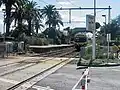 Northbound view from the Glen Eira Road level crossing, April 2005
 -
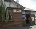 Station building and entrance to Platform 1,
November 2021 -
 Station at night
References
- ^ a b c d Estimated Annual Patronage by Network Segment Financial Year 2005-2006 to 2018-19 Department of Transport
- ^ a b c d e f g h i j k l Railway station and tram stop patronage in Victoria for 2008-2021 Philip Mallis
- ^ Annual metropolitan train station patronage (station entries) Data Vic
- ^ a b c d e f g h "Ripponlea". vicsig.net. Retrieved 20 January 2023.
- ^ a b c "Ripponlea Railway Station Complex". Victorian Heritage Database. Retrieved 15 July 2025.
- ^ a b "Access Guide". Metro Trains Melbourne. Retrieved 15 July 2025.
- ^ a b c "Sandringham Line". Public Transport Victoria. Retrieved 15 July 2025.
- ^ a b c "67 Melbourne University - Carnegie". Public Transport Victoria. Retrieved 15 July 2025.
- ^ a b c "623 Glen Waverley - St Kilda via Mount Waverley & Chadstone & Carnegie". Public Transport Victoria. Retrieved 15 July 2025.
- ^ "Ripponlea". Metro Trains Melbourne. Retrieved 15 July 2025.
- ^ "The Railways. Rippon Lea Station". The Argus (Melbourne). 29 April 1912. Retrieved 15 July 2025.
- ^ "Ripponlea Railway Station". Victorian Heritage Database. Retrieved 15 July 2025.
- ^ "Proposed Station at Glen Eira Road". The Argus (Melbourne). 19 July 1904. Retrieved 15 July 2025.
- ^ "Ripponlea Station". The Herald. 1 May 1912. Retrieved 15 July 2025.
- ^ "Ripponlea". Victorian Places. Retrieved 20 January 2023.
- ^ First, Jamie (7 January 2014). "The A-Z story of Melbourne's suburbs". Herald Sun. Retrieved 20 January 2023.
- ^ "Electrification". The Age. 24 May 1919. Retrieved 15 July 2025.
- ^ "Sandringham Line". Vicsig. Retrieved 15 July 2025.
- ^ Sinnatt, John (January 1990). "Level Crossing Protection". Somersault. Signalling Record Society Victoria. pp. 9–17.
- ^ "Services when the Metro tunnel opens". Daniel Bowen. 2 March 2023. Retrieved 15 July 2025.
- ^ "Route 67 - Yarra Trams". Yarra Trams. Retrieved 15 July 2025.
- ^ "Victoria East bus timetables & maps". CDC Victoria. Retrieved 15 July 2025.
External links
- Melway map at street-directory.com.au