Rastislavice
Rastislavice
Dögös | |
|---|---|
Municipality | |
 | |
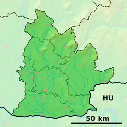 Rastislavice Location of Rastislavice in the Nitra Region  Rastislavice Location of Rastislavice in Slovakia | |
| Coordinates: 48°08′12″N 18°04′29″E / 48.13667°N 18.07472°E | |
| Country | |
| Region | |
| District | Nové Zámky District |
| First mentioned | 1936 |
| Area | |
• Total | 19.589 km2 (7.563 sq mi) |
| Elevation | 124 m (407 ft) |
| Population (2021)[3] | |
• Total | 951 |
| • Density | 49/km2 (130/sq mi) |
| Time zone | UTC+1 (CET) |
| • Summer (DST) | UTC+2 (CEST) |
| Postal code | 941 10 (pošta Tvrdošovce)[2] |
| Area code | 421-35[2] |
| Car plate | NZ |
| Website | www.obecrastislavice.sk |
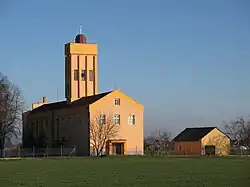
Rastislavice (Hungarian: Dögös) is a village and municipality in the Nové Zámky District in the Nitra Region of south-west Slovakia.
History
The village is new built in 1936.
Geography
The village lies at an altitude of 124 metres (407 ft) and covers an area of 19.589 km2 (7.563 sq mi). It has a population of about 920 people.
Ethnicity
 Slovaks 99%
 Hungarians 1%
Facilities
The village has a public library and a football pitch.
External links
 Media related to Rastislavice at Wikimedia Commons
- Official website

- Statistical Office of the Slovak Republic Archived 2007-11-16 at the Wayback Machine
- Rastislavice – Nové Zámky Okolie
- Official website of Rastislavice
References
- ^ "Hustota obyvateľstva - obce [om7014rr_ukaz: Rozloha (Štvorcový meter)]". www.statistics.sk (in Slovak). Statistical Office of the Slovak Republic. 2022-03-31. Retrieved 2022-03-31.
- ^ a b c "Základná charakteristika". www.statistics.sk (in Slovak). Statistical Office of the Slovak Republic. 2015-04-17. Retrieved 2022-03-31.
- ^ "Počet obyvateľov podľa pohlavia - obce (ročne)". www.statistics.sk (in Slovak). Statistical Office of the Slovak Republic. 2022-03-31. Retrieved 2022-03-31.