Rabaul Airport
Rabaul Airport Tokua Airport | |||||||||||
|---|---|---|---|---|---|---|---|---|---|---|---|
| Summary | |||||||||||
| Airport type | Public | ||||||||||
| Operator | Government | ||||||||||
| Location | Rabaul, Papua-New Guinea | ||||||||||
| Elevation AMSL | 49 ft / 15 m | ||||||||||
| Coordinates | 04°20′25″S 152°22′46″E / 4.34028°S 152.37944°E | ||||||||||
| Map | |||||||||||
 RAB Location of airport in Papua New Guinea | |||||||||||
| Runways | |||||||||||
| |||||||||||
Rabaul Airport, also called Tokua Airport, (IATA: RAB, ICAO: AYTK) is an airport serving Kokopo and Rabaul, the current and former capitals of East New Britain Province on New Britain island in Papua New Guinea.
History
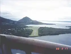
Originally, Kokopo and Rabaul was served by the former Lakunai Airfield. It was located at the foot of the Tavurvur volcano, near Matupit island. In 1994, a volcanic eruption destroyed the town and the airport, and a new airport was subsequently built and opened at Tokua. It was located on the opposite side of the Rabaul caldera.
The former airport was located at: 04°13′27″S 152°11′08″E / 4.22417°S 152.18556°E.[3]
A volcanic eruption closed the airport for a day in 2006.[4]
Facilities
The airport is 32 feet (10 m) above mean sea level. It has one runway designated 10/28 with an asphalt surface measuring 5,643 by 92 feet (1,720 m × 28 m).[1]
Airlines and destinations
| Airlines | Destinations |
|---|---|
| Air Niugini | Buka, Hoskins, Kavieng, Lihir Island, Port Moresby |
| Hevilift | Charter: Kavieng |
| PNG Air | Hoskins |
References
- ^ a b Airport information for AYTK from DAFIF (effective October 2006)
- ^ Airport information for RAB at Great Circle Mapper. Source: DAFIF (effective October 2006).
- ^ Airport information for AYRB at Great Circle Mapper.
- ^ "Rabaul's airport reopens after eruption". ABC News. October 11, 2006.
External links