Quebec Route 113
 Route 113 | ||||
|---|---|---|---|---|
 | ||||
| Route information | ||||
| Maintained by Transports Québec | ||||
| Length | 366.4 km[1] (227.7 mi) | |||
| History | ||||
| Major junctions | ||||
| South end | ||||
| North end | ||||
| Location | ||||
| Country | Canada | |||
| Province | Quebec | |||
| Major cities | Val-d'Or, Chibougamau, Senneterre | |||
| Highway system | ||||
| ||||
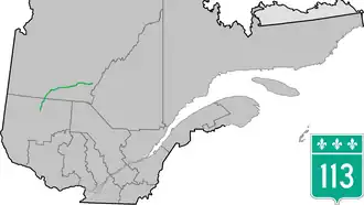
Route 113 is a north/south two lane highway in northern Quebec, Canada. It starts at Route 117 just north of the Louvicourt district of Val-d'Or and continues north and north-east roughly until Waswanipi from where it continues east until it ends at Route 167 in Chibougamau. For most of its length, Route 113 goes through areas that are sparsely populated but where logging is an important economic activity.
Municipalities along Route 113
- Val-d'Or
- Senneterre (parish)
- Senneterre (city)
- Lac-Despinassy
- Lebel-sur-Quévillon
- Eeyou Istchee Baie-James
- Waswanipi
- Chapais
- Chibougamau
Major intersections
| RCM or ET | Municipality | Km | Road | Notes |
|---|---|---|---|---|
Southern terminus of Route 113
| ||||
| La Vallée-de-l'Or | Val-d'Or | 0.0 | 117 SOUTH: to Mont-Laurier 117 NORTH: to Val-d'Or | |
| Senneterre | 36.8 | 386 WEST: to Amos | ||
| 104.8 | 397 SOUTH: to Lac-Despinassy | |||
| Jamésie | Chibougamau | 366.4 | 167 SOUTH: to Lac-Ashuapmushuan 167 NORTH: to Chibougamau | |
Northern terminus of Route 113
| ||||
See also
References
- ^ Ministère des transports, "Distances routières", page 58, Les Publications du Québec, 2005
External links
- Official Transport Quebec Road Map Archived 2020-11-16 at the Wayback Machine Provincial Route Map (Transports Quebec) (in French)
- Route 113 on Google Maps