Prospect Creek (New South Wales)
| Prospect Creek | |
|---|---|
 | |
| Location | |
| Country | Australia |
| State | New South Wales |
| Region | Sydney Basin (IBRA), Greater Western Sydney, Canterbury-Bankstown |
| LGAs | Blacktown, Cumberland, Fairfield, Liverpool, Canterbury-Bankstown |
| Physical characteristics | |
| Source | Prospect Reservoir |
| • location | north of Bulls Hill, Prospect |
| • coordinates | 33°50′2″S 150°53′20″E / 33.83389°S 150.88889°E |
| Mouth | confluence with the Georges River |
• location | Dhurawal Bay, Georges Hall |
• coordinates | 33°54′35″S 150°58′25″E / 33.90972°S 150.97361°E |
| Length | 26 km (16 mi) |
| Basin size | 98 km2 (38 sq mi) |
| Width | |
| • minimum | 5 m (16 ft) |
| • average | 11 m (36 ft) |
| • maximum | 30 m (98 ft) |
| Depth | |
| • minimum | 1 m (3.3 ft) |
| • average | 1.5 m (4.9 ft) |
| • maximum | 3 m (9.8 ft) |
| Basin features | |
| River system | Sydney Basin catchment |
| Tributaries | |
| • left | Burns Creek |
| • right | Orphan School Creek |
| Dam / Reservoir | Prospect Reservoir |
| [1][2] | |
Prospect Creek is an urban watercourse of the Georges River catchment that is located in the western region of Sydney, in New South Wales, Australia. Situated within the local government areas of Fairfield City and Canterbury-Bankstown Councils, the creek is 26 kilometres (16 mi) long, starting at the Prospect Reservoir at the top of the catchment and flows south-east to the Georges River at Georges Hall, as its tributary. In the north, the creek forms the border between Cumberland and Fairfield City Councils. Running through a prominent open space corridor, Prospect Creek drains the encompassing floodplain.[3]
The creek offers 8 km (5.0 mi) of recreational area and winds through a number of parks and reserves, including walkways and cycling paths that parallel the creek.[3] As Prospect Reservoir forms a part of the Sydney metropolitan water supply, the flow of the creek is regulated in accordance with the operational requirements of Sydney Water. The catchment area of the creek is approximately 98 square kilometres (38 sq mi), and is largely urbanised with industrial land uses, residential and open space for recreation.[2] For the early British settlers, the creek and the surrounding offered essential food and water resources, and thereby encouraged the development of local agriculture and industry.[3] The creek becomes affected by tides in the south.[4]
History
Indigenous
Prospect Creek was a traditional travel route that connected the Darug and D'harawal people. Early colonial evidence also indicates that the Bidjigal people lived closed to the creek.[6] There have been Aboriginal camps along the creek and as well as other areas of Sydney through the late 19th century and to as late as the 1950s.[7]
For the Aboriginal Australians, the creek and surrounding areas provided areas for hunting and gathering. Casuarina nuts were used in traditional medicine and basalt pebbles were used to create traditional axes.[3] The Cabrogal people near the creek acquired tidal system plants and animals, including bankias ('cobra worms'), woodlands foods such as possum and freshwater fish. Around thirty sites with Aboriginal artefacts, such as stone tools, had been identified around Prospect Creek.[8] The area near the Lansdowne Bridge at the creek, in what is now Shortland Brush, was a traditional sit down place for the Indigenous Australians as it featured ample aquatic and land foods.[8]
Colonial era
In the late 1780s, William Bradley went on an expedition from Rose Hill to Prospect Creek to determine whether Prospect Creek led to Botany Bay. Bradley described a place on the Creek where the water changed from fresh to salt with a drop of 4 feet (1.2 m). The presence of salt water confirmed Prospect Creek's connection to the sea.[9] Prospect Creek provided a camp for Pemulwuy, a Bidjigal warrior leader who led in the resistance against the British during the early colonisation.[3] In 1785, George Bass and Matthew Flinders began exploring the Georges River and went as far as Prospect Creek.[10] In 1789, Governor Arthur Phillip probed the country between Salt Pan Creek beginning at Prospect Creek.[11]
In December 1790, Captain Watkin Tench's party scoured the entire area from Cooks River to Prospect Creek to search for a group of resisting Aboriginal people during the Hawkesbury and Nepean Wars. In July 1791, Tench and his group spent a ‘miserable night’ in the riparian woodland and hoped to find fresh water on the banks of the creek, but instead they discovered salty water and a layer of thick ice covering the creek – Historians have claimed this may have occurred in the area that is now the Lansdowne Bridge.[8] In January 1797, Governor John Hunter travelled to Botany Bay to track the Georges River up for 40 kilometres (25 mi). Whilst doing so, he examined Prospect Creek, before he travelled to Parramatta.[12] Hunter stated that Prospect Creek, including Cabramatta Creek, become a series of ponds of freshwater as they head to the west. A feedlot for government cattle was constructed in front of "a fine chain of fresh water ponds", which was Prospect Creek around what is now Kenyon's Bridge in Smithfield, where 100 acres (40 ha) of she-oak forest was cut and another 50 acres (20 ha) burned down.[8]
In 1798, First Fleet Captain George Johnston received a land grant and constructed his first home located near Prospect Creek, close to Henry Lawson Drive and Beatty Parade. In 1800, just beside Prospect Creek, Lieutenant John Shortland from the First Fleet acquired an initial grant of 100 acres (40 ha) over the northern part of Lansdowne Reserve which he increased to 380 acres (150 ha).[13] In 1802, French explorer Francis Barrallier led an exploring team to the Gandangarra, where they sought passageway through the Blue Mountains in the southwest as they took a route that bypasses the marshy areas of Prospect Creek.[8]
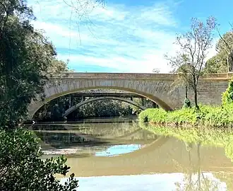
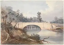
On January 1, 1806, two grants were made to James Gowan, one of them being on the northern bank of the creek. On January 1810, settlers Thomas Hanson and James Larra also received land grants just north of the creek, proximate to the Carramar railway station.[14] In 1820s, Joseph Kenyon's Woodlands on the eastern bank of Prospect Creek were described as having "immaculate lawns", "ornamental gardens" and a "showplace of the district".[8] In 1832 Surveyor-General Thomas Mitchell commissioned David Lennox for a sum of £1,083 ($2,166)[15] to build Lansdowne Bridge "at the intersection of Prospect Creek and Southern Street"; it was completed in 1836.[16]
In 1848, German explorer Ludwig Leichhardt and politician Sir Henry Parkes cooled their feet in Prospect Creek near Jacob Stein's vineyard. By the 1850s, there were numerous grand homes and estates beside the creek that became more accessible with the advent of the railways.[8] By 1860, an industrial zone (that included tannery, flour mills, a brewery) also became established in the area near the Prospect Creek.[3] In the 1880s, a woolwashing workshop was constructed on the creek at what is Fairfield Park Precinct today, with a brick weir to "keep a head of fresh water from the salt tides".[8]
Modern
During the 20th century, the lower Prospect Creek was a large part of life for residents in the Fairfield local government area with numerous pleasure grounds and recreation spaces along the creek including Latty's Pleasure Grounds, the Butterfly Hall, and Hollywood Park.[17] These venues were quite popular among tourists due to the area's rural feel and close proximately to the waterway, so popular in fact that the first games of Rugby League football in Australia, in early 1908, were trial games that took place in Lansvale, at Latty's Pleasure Grounds.[18]
From 1925, the Widemere Quarry Line crossed the creek until its closure in 1945.[19] Between the 1890s to around 1941, the creek became a popular weekend recreation area, and boating was common among visitors, who came to the picnic zones and hired boats there at Latty's Boatshed in what is now Heiden Park at Carramar.[20] Though with the advent of the Second World War in the early 1940s, access to the creek became restricted for visitors due to warfare security measures. Moreover, at that time, the part of the creek from Vine Street at Fairfield to its confluence with Georges River was commonly referred to as the 'George River' due to its watercraft navigability and wideness.[21] That section of the creek was also referred to as "Prospect River" and "Fairfield's River" by the locals.[22]
From the 1970s to 1990s, a small amusement park named Magic Kingdom operated in Lansvale on the banks of the creek and was a popular attraction for visitors.[23][24] Over time the creek has also slowly lost its shine as successive governments and communities turned their backs on the waterway, this coupled with industrialisation occurring upstream led to the declining water quality which is reflected in warnings today from authorities to avoid swimming in the catchment as it is not recommended.[25]
In 2005, a chain of illustrative Indigenous artworks were placed on the banks of the creek to encourage awareness about the Indigenous identity of the creek's corridor. The project constituted of four groups of artworks and path markers, displaying the flora and fauna of Prospect Creek, as observed by the Darug people. The artworks include four stories passed down through generations of Darug people, such as, the Australian raven and crows, The Eagle Warrior, The Casuarinas, and The Story of the Local Wattles.[26] In 2023, Sydney Water Corporation was convicted and fined $200,000 in the Land and Environment Court of NSW after 282,000 litres of sewage was spilled into the creek.[27]
Geography
Course
Prospect Creek flows south from Prospect Reservoir, just north of Bulls Hill in Prospect, within the Blacktown local government area. It then streams southeast through the local government areas of Cumberland, Fairfield, Liverpool and Bankstown, where it reaches its confluence with the Georges River at Georges Hall, as it flows into Dhurawal Bay in the Chipping Norton Lakes.[1] From north to south, the creek runs across the suburbs of Wetherill Park, Greystanes, Smithfield, Fairfield, Yennora, Canley Vale, Carramar, Lansdowne and Georges Hall. The creek's corridor extends across the Aboriginal Land Councils of Deerubbin and Gandangara.[3]
From northwest to southeast, the creek crosses roads such as Prospect Highway, Gipps Road, Cumberland Highway, Fairfield Road, The Horsley Drive, Fairfield Street, Vine Street, Hume Highway and then meanders parallel of Henry Lawson Drive as it heads south to Chipping Norton Lake (Dhurawal Bay).[3] Prospect Creek's tidal limit is located around the Liverpool & Inner West Line crossing at the Canley Vale/Carramar border and the tidal reach may extend to the confluence of Orphan School Creek just south of Riverview Road at the Fairfield/Canley Vale border.[4]
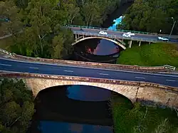
Bridges crossed include Carramar (Sandal Crescent) Railway Bridge which was constructed when the Main South Line was extended from Regents Park to Cabramatta in 1924,[28] Waterside Crescent Pedestrian Bridge which connects Cook Park in Canley Vale to Carrawood Park in Carramar, and Lansdowne Bridge, a sandstone arch bridge which has the largest span of any masonry bridge in Australia.[29]
Environment
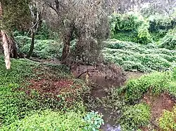
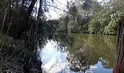
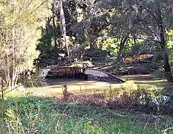
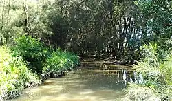
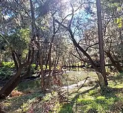
The creek's strip, being located between urban and industrial area, is a green natural corridor used for recreation purposes and ecological conservation, in addition to the environment having indigenous significance. The creek consists of remnant and altered vegetation communities, artificial and natural wetlands, grassy open areas and as well as detention basins. Its riparian vegetation is rather diverse and often compact, which consists of around 125 native and 96 introduced species. The creek features remnant vegetation ecozones such as Coastal Swamp Oak Forest, River-flat eucalypt forest and Shale-Gravel Transition Forest, with the first two being the most prominent zones.[3]
The wetland parts south of the Cumberland Highway feature the Australasian swamphen, the Australian wood duck, the Black swan, and the Night Heron, in addition to frogs, mammals, reptiles, fish (mullet, bream, black fish, carp) and other invertebrates. The strip between Widemere Road and the Cumberland Highway is the most abundant with species and lacks weeds, and therefore it is the most ecologically important zone. Its detention basins help the creek during periods of powerful flows, thereby hindering the banks from eroding.[3]
Ecological impact
Within the past 200 years the creek has been impacted by the surrounding unsustainable rural and urban development which has degraded its natural environment, in addition to the creek's health also being an issue with several State Government accounts. Industrial discharge (through stormwater), illegal dumping of cars and wastes, algae bloom, grease spills and raised fecal coliform levels have impacted the creek, in addition to a significant pesticide leak in February 2002.[3]
Revegetation and works improving the habitat on the creek's strip have been running since the 1986, which included removal of weeds and comprehensive tree planting (generally between Gipps Road and the Cumberland Highway). The Friends of Prospect Creek (FPC) was a group created to arrange successful Clean Up Australia Days, where local residents volunteer to clean up waste and plant over 17,000 trees and shrubs in Long Street Park at Smithfield, the location where the Warali Wali Track of the Great Kai'mia Way route was planned.[10]
Recreation
The most prominent recreational areas on the creek's corridor include, Gipps Road Sporting Complex, Rosford Street Reserve and the contiguous Long Street Park in Smithfield, Fairfield Park Precinct and Cawarra Park in Fairfield, Fairfield Road Park in Yennora, Makepeace Oval in Fairfield, Carrawood Park and Heiden Park in Carramar, Mirambeena Regional Park in Lansdowne, Garrison Point and Henry Lawson Reserve in Georges Hall, going from northwest to southeast. It also flows on the western fringes of Fairfield High School and just north of Bland Oak, a historical tree. Recreational hobbies in the creek's strip include dog-walking, cycling, playing and observing the local wildlife.[3]
There are walkways or cycling paths that parallel the creek, with one major one being the Prospect Creek cycleway, which is the longest, continuous shared walking path that runs alongside creek starts from Widmere Road, adjacent to the Liverpool–Parramatta T-way, in the northern periphery of Wetherill Park, and ends at Fairfield Road Park in Yennora, opposite of Yennora Fire Station. The walkabouts are within the surroundings of the Australian bushland, which include native trees such as eucalyptus.[30] Starting at Cook Park in Canley Vale, before crossing the creek into Carramar's Carrawood Park, the path continues to the Lansdowne Bridge and Hume Highway. It then passes through Shortland Brush and Flinders Slopes in Mirambeena Regional Park, and ending in Garrison Point Reserve at Georges Hall. The walkways and cycling paths are situated within an Australian bushland settings with many native trees such as eucalyptus found by the water's edge.[31]
The creek corridor's features interpretive signs for visitors to represent the creek in terms of Aboriginal legacy. Its visitors include local residents (as well as those outside Fairfield and Cumberland LGA areas), employees, sport teams, bush regeneration groups and school students, and is even used as a commuting substitute to driving. Though surveys have shown that the visitation rate is low, and people in the area are not informed about its existence.[3] Most forms of fishing are permitted in Prospect Creek, in both the tidal (lower) and freshwater (upper) catchments with fishing subject to bag and size limit regulations.[4] All vessels are permitted to travel along the creek including jet skies and boats, although a limit of 8 knots (9.2 mph) is enforced by the relevant authorities.[32]
Catchment
The creek's catchment area itself is a sub-catchment of the Georges River catchment, where it covers an area of 98 square kilometres (38 sq mi). Areas within the Prospect Creek Catchment include, Fairfield City (65.6%), Cumberland Council (13.7%), Canterbury-Bankstown (10.5%), Blacktown (7.8%) and Liverpool (2.4%). Some of the streams and drainage lines in the catchment do not permanently transport water, and rather would only do so after rain events.[33]
Burns Creek, Clear Paddock Creek, Green Valley Creek and Orphan School Creek are all part of the Prospect Creek catchment, in addition to being Prospect Creek's tributaries (with Burns Creek being the smallest tributary of the creek at Fairfield East). Wetlands and ponds within the Prospect Creek catchment include, Kaluna Reserve near Cumberland Highway in Smithfield, Gipps Road Pond at Jack Ferguson Reserve, De Freitas Wetland at Vine Street, Clarevale Wetland, Lake Mirambeena (Lansdowne) and Lake Gillawarna (Georges Hall).[33]
Drainage systems
As urban development grew in the area, several gullies and waterways that traditionally drained runoff into Prospect Creek were replaced by stormwater pipes.[34] Storm water drainage release into the creek at roads such as Long Street, Cumberland Highway and Gipps Road. There are sewage and water supply pipes that are affiliated with Long Street Park and Fairfield Road Park facilities, and as well as a sewer main on Long Street, and a portion of the Sydney Water Supply Pipeline that meanders along the western border of the creek.[3] Other systems that supply to the Prospect Creek include:[33]
- Wetherill Park Drain, a concrete bordered canal that releases water near the source of the creek
- Smithfield Main Drain, a natural waterway and piped system which drains areas of Fairfield West, Fairfield Heights and Smithfield
- Bellingers Drain, a piped system that drains portions of Fairfield and Fairfield Heights, where it discharges into a 400 metres (1,300 ft) long natural waterway before it runs into the creek
There are catchment drains that lead to Prospect Creek in a northeasterly direction; They consist of three concrete-lined, trapezoidal-shaped channels that are 3.8 kilometres (2.4 mi) in length, 1.5 metres (4 ft 11 in) to 1.75 metres (5 ft 9 in) in width and a height that ranges from approximately 2.0 metres (6 ft 7 in) to 3 metres (9.8 ft):[35]
- The "Main Channel" is 1,655 metres (5,430 ft) long, which is a culvert underneath the Cowpasture Road/The Horsley Drive roundabout that leads to its outlet into Prospect Creek, adjacent to Widemere Road in Wetherill Park.
- "Tributary 1", which is the next longest channel, has a length of 1,380 metres (4,530 ft), where it starts from Potter Close in Wetherill Park to its merging with the Main Channel.
- The shortest channel, the "Rosford Channel", is 775 metres (2,543 ft) in length, which begins from Victoria Street, traverses Redfern Street to the east, ending at Hassall Street in Smithfield. This used to be a natural gully up until the early 1970s.[34]
- There is also a minor detention basin in Emerson Street Reserve which is bordered by The Horsley Drive to the north and Emerson Street to the east, and a large pipe drainage network, which normally drains into one of the aforementioned channels or into Prospect Creek. Their construction was completed in the mid 1980s.
River status
In mid 2020, a proposal was submitted to upgrade a 6 kilometre (4 mi) stretch of Prospect Creek to a river status. The part of the creek that was to be designated as a river started at the confluence of Orphan School Creek and Prospect Creek, just west of Artie Street, at the border of Carramar and Canley Vale. The reason for this was that the creek south of its confluence with Orphan School Creek shows many qualities of a river; being wide and deep, being tidal and navigable by watercraft (particularly the section where it heads south into Dhurawal Bay at Garrison Point), in addition to locals referring that section of the creek as a river for over 180 years.[22] In September 2020, this proposal went before the Geographical Names Board of NSW (GNB) after Community Advocate, Lachlan Hyde, with the support of local state MPs, pushed the New South Wales Government on the matter.[36][37]
This stretch of the creek was going to be named Lennox River to honour Scottish-Australian stonemason David Lennox who designed and oversaw the construction of the Lansdowne Bridge which crosses this waterway. Guy Zangari (State Member for Fairfield), Tania Mihailuk (State Member for Bankstown), Nick Lalich (State Member for Cabramatta) and Wendy Lindsay (State Member for East Hills) all announced their support for the creek's river status in the NSW Parliament. Zangari stated, "I look forward to this stretch of Prospect Creek receiving an upgrade to river status and to [be] able to refer to it as the Lennox River, a name change that is overdue and eagerly anticipated by the residents of Fairfield."[22][38]
Though despite all the support for its river status, the proposal was ultimately rejected by the NSW Geographical Names Board.[39]
References
- ^ a b "Prospect Creek". Geographical Names Register (GNR) of NSW. Geographical Names Board of New South Wales. Retrieved 10 April 2013.
- ^ a b "Prospect Creek". Rivers and Creeks. Bankstown City Council. Retrieved 10 April 2013.
- ^ a b c d e f g h i j k l m n "Prospect Creek Open Space Corridor" (PDF). Cumberland City Council. June 2004. Retrieved 3 July 2025.
- ^ a b c "Prospect Creek Fishing". Parliament of New South Wales. Retrieved 4 July 2025.
- ^ "Lansdowne Bridge over Prospect Creek". New South Wales Department of Roads and Maritime. 7 July 2014. Archived from the original on 23 September 2016. Retrieved 3 November 2015.
- ^ "Prospect Hill – History before 1788". Spakathy.name. Retrieved 2 July 2025.
- ^ "Contested Waterways – Aboriginal resistance in early colonial Sydney". Cumberland City Council. Retrieved 2 July 2025.
- ^ a b c d e f g h Stephen Gapps (2009). "Cabrogal to Fairfield City: A History of a Multicultural Community". Wakeley, New South Wales: Fairfield City Council. Retrieved 17 July 2025.
- ^ A Voyage to New South Wales – William Bradley NLA No.Aus 68-1986 p168
- ^ a b Tassia Kolesnikow (February 2021). "The Great Kai'Mia Way" (PDF). Sutherland Shire Environment Centre. Retrieved 2 July 2025.
- ^ "1780s". University of Sydney. Retrieved 2 July 2025.
- ^ Grace Karskens (2016). "Phillip and the Eora – Governing race relations in the colony of New South Wales". Sydney Journal, vol 5, no 1 (2016). University of Technology Sydney. Retrieved 2 July 2025.
- ^ "Plan of Management for Mirambeena Regional Reserve" (PDF). City of Canterbury Bankstown. Retrieved 5 July 2025.
- ^ Tom Fitzpatrick (12 December 1956). "The Early History of Fairfield District". The Biz. Retrieved 2 July 2025.
- ^ "Votes and Proceedings". The Sydney Gazette and New South Wales Advertiser. Vol. XXX, no. 2192. 11 October 1832. p. 3 – via National Library of Australia.
- ^ "Lennox's Lansdowne Bridge" (PDF). The Institution of Engineers Australia. March 1986. Archived (PDF) from the original on 17 November 2015. Retrieved 6 November 2015.
- ^ "Summertime in Fairfield". Fairfield City Open Libraries: Heritage Blog. 18 January 2016. Retrieved 12 March 2021.
- ^ Pollon, Frances (1990). Book of Sydney Suburbs. North Ryde (New South Wales): Angus & Robertson. p. 148. ISBN 0207144958.
- ^ Karina Hall (2009). "The Widemere Quarry Branch". NSWRail.net. Retrieved 18 July 2025.
- ^ a b "1904 Fairfield Von Heiden Upright Piano". The Migration Heritage Centre at the Powerhouse Museum. Retrieved 15 July 2025.
- ^ "Prospect Creek flowing through Fairfield Park, Fairfield NSW". Fairfield City Council. Retrieved 15 July 2025.
- ^ a b c Zangari, Guy (20 October 2020). "Prospect Creek". Parliament of NSW.
- ^ "We Remember Magic Kingdom at Lansvale". WSFM 101.7 Sydney. Retrieved 14 March 2021.
- ^ Pitt, Helen (13 July 2019). "Paradise Lost: Sydney's forgotten theme parks". The Sydney Morning Herald. Retrieved 14 March 2021.
- ^ "Chipping Norton Lake Scheme" (PDF). NSW Coastal Explorer. Department of Environment and Planning. Retrieved 29 March 2016.
- ^ "Aboriginal heritage in Cumberland". Cumberland City Council. Retrieved 2 July 2025.
- ^ Sydney Water fined for polluting Prospect Creek Prime Creative Media. Retrieved 7 December 2023.
- ^ "Carramar (Sandal Crescent) Railway Bridge | NSW Environment, Energy and Science". environment.nsw.gov.au. Retrieved 12 March 2021.
- ^ "Lansdowne Bridge | NSW Environment, Energy and Science". environment.nsw.gov.au. Retrieved 12 March 2021.
- ^ King M & Associates (1997) Recreation Needs Assessment Study prepared for Fairfield City Council
- ^ King M & Associates (1997) Recreation Needs Assessment Study prepared for Fairfield City Council
- ^ "Prospect Creek Vessels". Parliament of NSW. 24 November 2020.
- ^ a b c 5 Creeks: Facts & Figures Fairfield City Council. Retrieved 6 December 2023.
- ^ a b "Smithfield West Overland Flood Study" (PDF). Fairfield City Council. March 2016. Retrieved 22 July 2025.
- ^ Wetherill Park Overland Flood Study Fairfield City Council. February 2015. Retrieved 7 December 2023.
- ^ Dalton, Mike (6 November 2020). "Turning The Tide". Channel 9 News Sydney.
- ^ "Creek likely to get 'river' status after local's push". LocalNewsPlus. 10 November 2020. Retrieved 12 March 2021.
- ^ Lindsay, Wendy (30 October 2020). "Lennox River Proposal" – via Facebook.
- ^ "Lennox River". Geographical Names Board. NSW Government. Retrieved 17 August 2025.
External links
- "Georges River catchment" (map). Office of Environment and Heritage. Government of New South Wales.