Pontarlier
Pontarlier | |
|---|---|
Subprefecture and commune | |
 Saint-Bénigne Church and the Palace of Justice | |
 Coat of arms | |
Location of Pontarlier | |
 Pontarlier  Pontarlier | |
| Coordinates: 46°54′24″N 6°21′20″E / 46.9067°N 6.3556°E | |
| Country | France |
| Region | Bourgogne-Franche-Comté |
| Department | Doubs |
| Arrondissement | Pontarlier |
| Canton | Pontarlier |
| Intercommunality | Grand Pontarlier |
| Government | |
| • Mayor (2020–2026) | Patrick Genre[1] |
Area 1 | 41.35 km2 (15.97 sq mi) |
| Population (2022)[2] | 17,928 |
| • Density | 430/km2 (1,100/sq mi) |
| Time zone | UTC+01:00 (CET) |
| • Summer (DST) | UTC+02:00 (CEST) |
| INSEE/Postal code | 25462 /25300 |
| Elevation | 811–1,320 m (2,661–4,331 ft) (avg. 837 m or 2,746 ft) |
| 1 French Land Register data, which excludes lakes, ponds, glaciers > 1 km2 (0.386 sq mi or 247 acres) and river estuaries. | |
Pontarlier (French: [pɔ̃.taʁ.lje] ; Latin: Ariolica) is a commune and one of the two sub-prefectures of the Doubs department in the Bourgogne-Franche-Comté region in eastern France.
Nestled in the heart of the Jura Mountains near the Swiss border, the town lies along the Doubs River and occupies the Arlier plain at approximately 830–837 m elevation. It is overshadowed by the Grand Taureau peak, which reaches 1,323 m.
With a recorded 2022 population of 17,928 residents known as Pontissaliens and Pontissaliennes, Pontarlier serves as the economic and commercial center of the Haut‑Doubs region Pontarlier occupies a site that has been inhabited since Neolithic times. Known as Ariolica in antiquity, it was an important transit point between Gaul and Italy. During the Middle Ages, it flourished as a trading hub on the route linking the Mediterranean and the North Sea. The city endured significant turmoil—most notably during the Thirty Years’ War, when it was besieged and largely destroyed in 1639 by troops under Bernard of Saxe‑Weimar, and suffered multiple destructive fires in the 17th and 18th centuries.
At the start of the 19th century, Pontarlier became known as France's "absinthe capital" when Henri‑Louis Pernod established the Pernod Fils distillery in 1805. By the early 20th century, around twenty distilleries employed nearly 3,000 people, thanks to booming national demand. That era abruptly ended with the French ban on absinthe in 1915. The modern revival of absinthe since 2001 has reconnected Pontarlier with this storied past.
Today, Pontarlier is the leading economic hub of the Haut‑Doubs area. Its diversified industrial sector includes major employers such as Schrader (Valves), Nestlé France (producing Nesquik powder locally), and Hifi Filter France (specializing in filtration). The town has over 400 retail outlets, spread across multiple commercial zones, drawing shoppers from France and neighboring Switzerland. Pontarlier also supports regional food and beverage traditions. The Badoz dairy produces Comté and Mont d’Or cheeses, while distilleries like Pierre Guy continue crafting traditional absinthe, Pontarlier aperitif (anise-flavored), and other regional liqueurs.
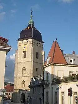
Pontarlier has a rich architectural and cultural heritage. The Church of Saint‑Bénigne, reconstructed between 1651 and 1666 in the Romanesque‑Gothic style typical of Franche‑Comté, features an imperial‑dome bell tower and stained‑glass windows by Alfred Manessier, and is officially listed as a historic monument. The classical triumphal arch of the Porte Saint‑Pierre, erected from 1771 to 1773 to commemorate the town's reconstruction, stands as another major symbol of the city. The Municipal Museum of Art and History, housed in a 15th‑century manor, showcases archaeological treasures, regional artifacts, decorative arts, and items connected to absinthe.
History
Pontarlier occupies the ancient Roman station of Ariolica, in Gallia and is placed in the Tables on the road from Urba (modern Orbe, Canton Vaud, Switzerland), to Vesontio (modern Besançon). Although the distances in the Antonine Itinerary do not agree with the real distances, French geographer D'Anville recognized a transposition of the numbers. The Theodosian Tabula names the place "Abrolica", which William Smith states as a possible error of transcription.[3]
After the Burgundian invasion in the 5th century, Pontarlier became the best route for trade from the kingdom of Burgundy to Switzerland, Germany or Lombardy. Until the 17th century it was the easiest way to cross the Jura Mountains.
Pontarlier is one of the staging posts from northern France, Britain and the Benelux countries for the Via Francigena, now a walking route to Rome with a starting point in Canterbury, England. It is recorded as being the stop on day 57 of Sigeric the Serious, the then Archbishop of Canterbury on his return from Rome in 990 AD, having been given his pallium, or token of rank. Discussion continues as to whether he came over the Jura from the direction of Yverdon-les-Bains to the south-east or through a valley from Jougne to the south.
The city of Pontarlier is briefly mentioned in Victor Hugo's Les Misérables. It was to this city that convict Jean Valjean was to report for his parole after being released from the galleys. Breaking these instructions is a major turning point in the novel, and also creates some major conflict for Valjean later in the story. The city is also the main location of the 1962 French film The Seventh Juror.
Pontarlier was famous for the production of absinthe until its ban in 1915. The distilleries switched over to producing a particular type of pastis, the "Pontarlier". With the ban partially lifted in the 1990s, Pontarlier distilleries are once again producing absinthe.
Population
|
| ||||||||||||||||||||||||||||||||||||||||||||||||||||||||||||||||||||||||||||||||||||||||||||||||||||||||||||||||||
| Source: EHESS[4] and INSEE (1968–2017)[5] | |||||||||||||||||||||||||||||||||||||||||||||||||||||||||||||||||||||||||||||||||||||||||||||||||||||||||||||||||||
Transportation
The commune has a railway station, Pontarlier, on the Frasne–Les Verrières and Neuchâtel–Pontarlier lines between France and Switzerland.
Notable people
- Sébastien Rale (1652–1724), missionary and lexicographer
- Charles Antoine Morand, Napoleonic general
- Henri-Louis Pernod, distiller
- Edgar Faure, member of the Académie française, president of the city council, and mayor
- Philippe Grenier, physician and first Muslim member of French parliament
- Xavier Marmier, writer and poet
- Robert Fernier, painter
- Pierre Bichet, painter
- Vincent Defrasne, biathlete
- Florence Baverel-Robert, biathlete
Sights
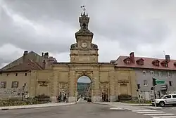
- Triumphal arch of the Porte Saint-Pierre (18th century)
- Stained glass created in 1976 by painter Alfred Manessier in the Church of Saint-Bénigne, a 17th-century church that blends Romanesque, Gothic, and Franc-Comtois architectural styles. Originally built in the 11th century, it was largely rebuilt between 1651 and 1666 after being damaged during the Thirty Years' War. The church features a distinctive bell tower topped with an imperial dome, typical of the region. It remains an active place of worship and a historical monument.
- Fort de Joux (between 11th and 19th century)
International relations
Pontarlier is twinned with:
.svg.png) Yverdon-les-Bains, Switzerland[6]
Yverdon-les-Bains, Switzerland[6] Villingen-Schwenningen, Germany
 Zarautz, Spain
Climate
| Climate data for Pontarlier (1991–2020 normals, extremes 1897–present) | |||||||||||||
|---|---|---|---|---|---|---|---|---|---|---|---|---|---|
| Month | Jan | Feb | Mar | Apr | May | Jun | Jul | Aug | Sep | Oct | Nov | Dec | Year |
| Record high °C (°F) | 20.1 (68.2) |
21.5 (70.7) |
24.9 (76.8) |
27.0 (80.6) |
33.0 (91.4) |
35.0 (95.0) |
38.0 (100.4) |
37.0 (98.6) |
32.8 (91.0) |
29.4 (84.9) |
23.5 (74.3) |
20.3 (68.5) |
38.0 (100.4) |
| Mean daily maximum °C (°F) | 4.6 (40.3) |
5.7 (42.3) |
9.8 (49.6) |
13.6 (56.5) |
17.3 (63.1) |
21.2 (70.2) |
23.5 (74.3) |
23.5 (74.3) |
19.1 (66.4) |
15.0 (59.0) |
8.8 (47.8) |
5.1 (41.2) |
13.9 (57.0) |
| Daily mean °C (°F) | 0.5 (32.9) |
1.0 (33.8) |
4.6 (40.3) |
7.9 (46.2) |
11.8 (53.2) |
15.4 (59.7) |
17.5 (63.5) |
17.3 (63.1) |
13.4 (56.1) |
9.8 (49.6) |
4.6 (40.3) |
1.3 (34.3) |
8.8 (47.8) |
| Mean daily minimum °C (°F) | −3.6 (25.5) |
−3.7 (25.3) |
−0.6 (30.9) |
2.2 (36.0) |
6.2 (43.2) |
9.7 (49.5) |
11.4 (52.5) |
11.1 (52.0) |
7.7 (45.9) |
4.6 (40.3) |
0.3 (32.5) |
−2.5 (27.5) |
3.6 (38.5) |
| Record low °C (°F) | −32.0 (−25.6) |
−26.2 (−15.2) |
−21.7 (−7.1) |
−10.8 (12.6) |
−6.0 (21.2) |
−2.0 (28.4) |
0.8 (33.4) |
0.1 (32.2) |
−3.3 (26.1) |
−9.7 (14.5) |
−16.4 (2.5) |
−23.2 (−9.8) |
−32.0 (−25.6) |
| Average precipitation mm (inches) | 115.3 (4.54) |
105.4 (4.15) |
107.5 (4.23) |
105.0 (4.13) |
139.9 (5.51) |
124.5 (4.90) |
123.1 (4.85) |
121.3 (4.78) |
113.6 (4.47) |
128.9 (5.07) |
131.4 (5.17) |
147.7 (5.81) |
1,463.6 (57.62) |
| Average precipitation days (≥ 1.0 mm) | 12.9 | 11.8 | 11.9 | 12.2 | 14.9 | 12.3 | 12.1 | 11.1 | 10.7 | 13.0 | 12.8 | 14.0 | 149.7 |
| Source: Meteociel[7] | |||||||||||||
See also
References
- ^ "Répertoire national des élus: les maires". data.gouv.fr, Plateforme ouverte des données publiques françaises (in French). 2 December 2020.
- ^ "Populations de référence 2022" (in French). The National Institute of Statistics and Economic Studies. 19 December 2024.
- ^
 Smith, William, ed. (1854). "Ariolica". Dictionary of Greek and Roman Geography. Vol. 1. London: John Murray. p. 215.
- ^ Des villages de Cassini aux communes d'aujourd'hui: Commune data sheet Pontarlier, EHESS (in French).
- ^ Population en historique depuis 1968, INSEE
- ^ "Association Suisse des Communes et Régions d'Europe". L'Association suisse pour le Conseil des Communes et Régions d'Europe (ASCCRE) (in French). Archived from the original on 24 July 2012. Retrieved 20 July 2013.
- ^ "Normales et records pour Pontarlier (25)". Meteociel. Retrieved 21 November 2024.
External links
- City council website (in French)
- Aeroclub of Pontarlier WebSite (in French)