Polanka nad Odrou
Polanka nad Odrou | |
|---|---|
.jpg) Municipality district office | |
 Flag  Coat of arms | |
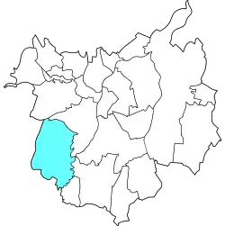 Location of Polanka nad Odrou in Ostrava | |
| Coordinates: 49°47′15″N 18°9′44″E / 49.78750°N 18.16222°E | |
| Country | |
| Region | Moravian-Silesian |
| Municipality | Ostrava |
| Area | |
• Total | 17.25 km2 (6.66 sq mi) |
| Population (2021)[1] | |
• Total | 1,504 |
| • Density | 87/km2 (230/sq mi) |
| Time zone | UTC+1 (CET) |
| • Summer (DST) | UTC+2 (CEST) |
| Postal code | 725 25 |
| Website | polanka |
Polanka nad Odrou is a borough and municipal part of the city of Ostrava, Czech Republic. It is situated in the southwestern part of the city on the left bank of the Oder River. Originally a separate municipality, it was incorporated into Ostrava in 1976, as a part of the borough Poruba.[2][3] On 24 November 1990, it separated from Poruba and became one of the 23 self-governing boroughs of Ostrava.[4]
Etymology
The word polanka is the diminutive form of polana, which is an Old Czech word for a deforested area transformed into a field.[5] The suffix nad Odrou translates as 'above the Oder River', which is referencing to the area's location.[6]
Gallery
-
 Fishpond Pod zámkem
 -
 Park
Park -
.jpg) Chapel
Chapel
References
- ^ "Výsledky sčítání 2021 – otevřená data" (in Czech). Czech Statistical Office. 21 December 2022.
- ^ "Z kroniky obce". SDH Polanka. Retrieved 9 July 2025.
- ^ "Historie obce" (in Czech). City of Ostrava. Retrieved 9 July 2025.
- ^ "Ostravské městské obvody". eOstrava.cz (in Czech). Retrieved 7 July 2025.
- ^ "Polanka" (in Czech). Czech Radio. 18 September 2019. Retrieved 9 July 2025.
- ^ "Ostrava - Polanka nad Odrou - Městská část". Turistika.cz (in Czech). Retrieved 9 July 2025.