Penama Province
Penama | |
|---|---|
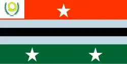 Flag | |
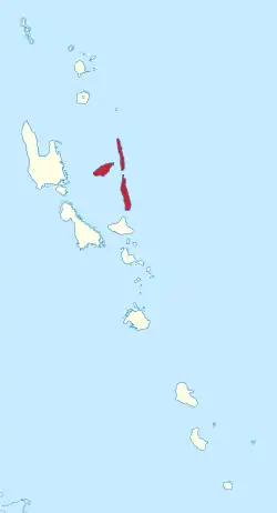 Penama in Vanuatu | |
| Country | |
| Capital | Saratamata |
| Area | |
• Total | 1,198 km2 (463 sq mi) |
| Population (2016)[1] | |
• Total | 32,543 |
| • Density | 27/km2 (70/sq mi) |
Penama is one of the six provinces of Vanuatu, located in the northeast of the country. And it consists of three major islands:
The name Penama is derived from the initial letters of PENtecost, Ambae and MAewo.
Administrative divisions
Penama Province are subdivided into ten area councils, which are further subdivided into populated places (i.e.: villages, communities, etc.).
- Central Pentecost I Area Council
- Central Pentecost II Area Council
- East Ambae Area Council
- North Ambae Area Council
- North Maewo Area Council
- North Pentecost Area Council
- South Ambae Area Council
- South Maewo Area Council
- South Pentecost Area Council
- West Ambae Area Council
Population
It has a population of 30,819 (2009 census) [2] people and an area of 1,198 km2. Its capital is Saratamata on Ambae, but there are plans to move the capital to a different island due to a volcanic eruption [3]
Islands
| Name | Population | Area |
|---|---|---|
| Ambae | 10,407 | 398 km2 (154 sq mi) |
| Maewo | 3,569 | 269 km2 (104 sq mi) |
| Pentecost | 16,843 | 490 km2 (190 sq mi) |
References
- ^ "Census & Surveys". Vanuatu National Statistics Office. Archived from the original on 2013-05-01. Retrieved 27 May 2013.
- ^ 2009 Census Summary release final Archived 2013-12-21 at the Wayback Machine - Government of Vanuatu
- ^ "Global Volcanism Program | Ambae".
External links
 Media related to Penama Province at Wikimedia Commons
15°30′S 168°00′E / 15.500°S 168.000°E