Peer Gynt (mountain road)
| Peer Gynt Road | |
|---|---|
| Peer Gyntvegen (Norwegian) | |
 | |
| Route information | |
| Length | 57 km[1] (35 mi) |
| Status | Private toll road Only open in summer |
| Major junctions | |
| West end | Dalseter, Sør-Fron Municipality (61°28′10″N 9°27′34″E / 61.4695°N 9.4594°E) |
| East end | Skei, Gausdal Municipality (61°20′18″N 10°04′52″E / 61.3384°N 10.0811°E) |
| Location | |
| Country | Norway |
| Highway system | |
| |
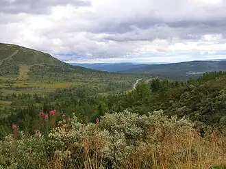
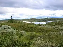
Peer Gynt Road (Norwegian: Peer Gyntvegen) is a 57-kilometre (35 mi) long tourist mountain road, named for the folkloric character Per Gynt. It is a privately owned toll road. It runs in the east of Norway in Innlandet county with views of Jotunheimen, along the villages Skeikampen, Fagerhøy, Gålå, Fefor, and Dalseter. The road goes through Sør-Fron Municipality, Nord-Fron Municipality, Ringebu Municipality, and Gausdal Municipality.[1][2]
The road has 2 sections: Dalseter to Fefor and then from Gålå to Skei.[3] The part that connects the two parts is a Norwegian county road (not a private toll road). The 2 private sections are only open in the summer, usually opening around 1 June and closing when the snow starts. The road is not maintained in the winter.[1]
References
- ^ a b c "Peer Gynt vegen". PeerGyntVegen.no. Retrieved 29 July 2025.
- ^ Thorsnæs, Geir, ed. (26 November 2024). "Peer Gynt-vegen". Store norske leksikon (in Norwegian). Foreningen Store norske leksikon. Retrieved 29 July 2025.
- ^ "Kart". PeerGyntVegen.no (in Norwegian). Retrieved 29 July 2025.
External links
- Official website (in Norwegian)
- Information (pdf-bestand, 2,3 MB)
- Fagerhøy