Pays de Faverges
Pays de Faverges | |
|---|---|
Natural region | |
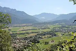 Faverges Valley, viewed from the oratory of Entrevernes, with the summit of La Belle Étoile (1841 m) in the background. | |
| Coordinates: 45°44′N 6°17′E / 45.733°N 6.283°E | |
| Country | |
| Region | Auvergne-Rhône-Alpes |
| Department | Haute-Savoie |
| Communes | Faverges-Seythenex, Doussard, Giez, Chevaline, Lathuile, Saint-Ferréol, Val de Chaise |
| Main town | Faverges-Seythenex |
| Area | |
• Total | 571.93 km2 (220.82 sq mi) |
| Geology | Annecy Trough |
| Topography | Bauges Massif, Bornes Massif (Alps) |
| Water bodies | Eau Morte, Chaise |
The Pays de Faverges or Faverges Valley is a small natural region located south of Lake Annecy in the Haute-Savoie department of the Auvergne-Rhône-Alpes region. It forms the central part of the Annecy Basin, surrounded by the Bauges Massif to the south, the Bornes Massif to the north, and the eastern end of the Aravis Range. The Pays de Faverges is a Savoyard region within the Canton of Faverges-Seythenex, 2nd constituency of Haute-Savoie, Annecy Arrondissement, and Haute-Savoie department.[1]
Geography

Location
The Pays de Faverges is a valley situated upstream of the cluse and Lake Annecy, also known as the Faverges Valley. It is a distinct subregion within the broader Annecy Basin.[note 1] The area spans approximately 12 kilometres (7.5 mi) east to west and 14 kilometres (8.7 mi) north to south. Geographer Raoul Blanchard described it as "a deep, narrow, and winding valley, the true archetype of a mountain valley," contrasting it with the larger intra-Alpine valleys of the foreland.[3]
The Faverges Valley is a basin or depression formed by the Annecy-Ugine glacial trough, sometimes referred to as the "Faverges Trough" for this section.[4] Its flat valley floor constitutes an alluvial plain.[4] Near Faverges, the valley narrows into a cluse. Elevations range from approximately 470 metres (1,540 ft) on the western edges to about 500 metres (1,600 ft) on the opposite slopes. From certain vantage points in the commune, the peak of Mont Blanc is visible to the northeast.[3]
Primarily situated on the plain and slopes of the surrounding massifs, except for the commune of Montmin,[3] the valley is traversed by two mountain streams: the Saint-Ruph (or Eau Morte), originating in the Bauges Massif to the west and flowing into Lake Annecy to the north, and the Chaise, originating in the Bornes Massif to the east and joining the Arly river in Ugine, in the neighboring Savoie department.[4]
The main peaks of this subregion include La Tournette (2,351 metres (7,713 ft)), Pointe de la Sambuy (2,198 metres (7,211 ft)), Mont Trélod (2,181 metres (7,156 ft)), Dent de Cons (2,062 metres (6,765 ft)), Pointe de la Beccaz (2,041 metres (6,696 ft)), and Crêt des Mouches (2,032 metres (6,667 ft)).[5]
Communes
.JPG)
The Pays de Faverges is administratively centered around the Communauté de communes des Sources du Lac d'Annecy, comprising seven communes, plus the village of Montmin, merged with Talloires in 2016 to form Talloires-Montmin, all within the Canton of Faverges-Seythenex.[3]
| Name | INSEE code | Demonym | Area (km²) | Population (2014) | Density (pop./km²) |
|---|---|---|---|---|---|
| Faverges-Seythenex † | 74123 | 59.27 | 7,611 | 128 | |
| Doussard | 74104 | Doussardiens | 20.14 | 3,607 | 179 |
| Giez | 74135 | Gicans | 12.65 | 561 | 44 |
| Chevaline | 74072 | Chevalinois | 14.16 | 204 | 14 |
| Lathuile | 74147 | Lathuiliens | 8.76 | 1,009 | 115 |
| Saint-Ferréol | 74234 | Saint-Ferréoliens | 16.79 | 817 | 49 |
| Val de Chaise | 74167 | 18.70 | 1,305 | 70 | |
| † Seat of the intercommunality | |||||
Transport
The valley is crossed by the former RN508, now D1508, connecting north to Annecy (approx. 40 minutes (2,400 s)) and south to Albertville (approx. 25 minutes (1,500 s)) via Ugine (approx. 20 minutes (1,200 s)).[6] A bypass skirts Faverges’ town center to the north, established in 1993.[7] Southward, the A41 autoroute is accessible 19 kilometres (12 mi) away at the Albertville exit, leading to Tarentaise Valley ski resorts or the Combe de Savoie, connecting to the Maurienne valley or the cities of Chambéry and Grenoble. Northward, through Annecy, the A430 autoroute is reachable (Annecy-South exit at 25 kilometres (16 mi) or Annecy-North at 28 kilometres (17 mi)), linking to the Arve Valley to the east or Chambéry via Aix-les-Bains to the west. The A40 autoroute, known as the "White Motorway," can be accessed via the former RN508 toward Frangy.[6]
The D1508 sees approximately 8,100 vehicles daily, with heavy goods vehicles accounting for about 85% of traffic.[6]
From Annecy, connections are available to the rail network at Annecy station’s multimodal platform or to flights from Annecy–Haute-Savoie–Mont Blanc Airport (25 kilometres (16 mi)) in Meythet. For international flights, options include Lyon–Saint-Exupéry Airport (150 kilometres (93 mi), approx. 1h45) or the closer Geneva Airport in Switzerland (75 kilometres (47 mi), approx. 1h05).[6]
A 30 kilometres (19 mi) cycle path, built on a former railway line along the D1508, runs between Annecy and Albertville, ending in Haute-Savoie at Marlens but extending into Savoie.[8][9] The final section from Giez to Marlens was completed between 2004 and 2005.[9] Managed by the Syndicat mixte du lac d'Annecy (SILA), this "Voie Verte" is one of France’s most popular cycle paths.[9]
Boats from Doussard’s pier, operated by the Lake Annecy Cruise Company, offer three daily connections to Annecy.[10]
History
.JPG)
The Faverges plain shows evidence of occupation from the Chalcolithic period. The Viuz-Faverges Archaeological Museum displays a copper axe from Englannaz (Doussard, Saint-Ferréol), dated to the "Copper Age," when stone tools were supplemented with worked copper.[3]
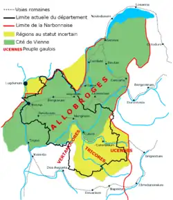
The valley was part of the Allobroges territory, controlling the flat foreland between the Rhône and the Alps.[11] The Romans intervened in the 2nd century BC, and after pacification, built a secondary road from Turin to Geneva via the mansio Casuaria (Viuz village, Faverges), which developed in the 1st century AD.[12] This Roman road roughly followed the former RN508’s route.[3] Traces have been found in nearby areas (Bredannaz, Bout-du-Lac, Faverges).[3]
In 1016, King Rudolph III of Burgundy granted his wife, Queen Ermengarde, rights over Dulsatis (Doussard), Marsiacum (Marceau), Vesonam (Vesonne), and Marlendis (Marlens). Medieval records, such as the late 12th to early 13th-century cartulary of Talloires Abbey, mention local villages and parishes.[13]
In the early Middle Ages, the valley was divided between regional powers: the seigneuries of Beauvivier, Verthier, and Lathuile, linked to the Duin family, belonged to the County of Geneva, while Giez and Faverges, with its keep controlling local roads, were vassals of the County of Savoy. By the late 14th century, Faverges was enfeoffed to the County of Geneva. It became a châtellenie encompassing Cons, Doussard, Giez, Marlens, and Saint-Ferréol.[14] In 1401, Amadeus VIII, Duke of Savoy purchased the County of Geneva, diminishing Faverges’ strategic role.[15]
From the late 18th century, Faverges developed proto-industry, particularly cotton and silk processing, led by the Duport family.[16][17][18] The Dictionnaire du duché de Savoie (1840) notes that Viuz and Les Murets produced high-quality wine, unlike other local products.[19]
In 1902, silk weaving revived with investments from Swiss industrialist Stünzi.[20][21] In 1909, another Swiss firm, Stäubli, established a factory producing dobbies for weaving looms.[21] In the early 1920s, Simon Tissot-Dupont, from Saint-Ferréol but based in Paris, founded an ST Dupont factory in Faverges.[15][21]
Administration
The Pays de Faverges is partly managed by the Communauté de communes des Sources du Lac d'Annecy, headquartered in Faverges-Seythenex.[22]
Economy
Agriculture
- Mountain agriculture: livestock, cheese, fodder, honey.
The region produces AOC cheeses such as Abondance, Reblochon, Chevrotin, and Tome des Bauges, alongside PGI products like Tomme de Savoie, Emmental de Savoie, and Savoy fruits (apples, pears).[23]
Industry and commerce
- Small and medium industries in Faverges.
- Industrial jobs in Ugine and Albertville.
- Employment opportunities in Annecy and Geneva.
- Local crafts.
The Pays de Faverges supports a mix of small and medium industries, particularly in Faverges, with additional industrial employment in nearby Ugine and Albertville. Opportunities also exist in Annecy and Geneva, alongside a tradition of local craftsmanship.[6]
Tourism
The Pays de Faverges is a tourism hub, leveraging its proximity to Lake Annecy (Doussard), ski resorts like La Sambuy-Seythenex, Val de Tamié, and Montmin, and local heritage (museums, castles). Tourism is promoted by the Communauté de communes des Sources du Lac d'Annecy’s tourism office, established in the 1980s in Faverges’ former town hall. The region offers around 12,300 tourist beds across approximately 50 establishments, with 50% in campsites.[24] The Château de Faverges, acquired by the commune in 1980, serves as an associative holiday center with 400 beds and dining facilities.[25] The Seythenex resort’s development in the 1980s was supported by a station-valley contract.[26]
Culture and heritage
Monuments, sites, and natural attractions
Museums
- Viuz-Faverges Archaeological Museum, adjacent to the Église Saint-Jean-Baptiste de Viuz, built on a former Roman temple.[27]
- Butterfly and Insect Museum at the castle.[28]
Architectural heritage
- Ancient baths of Faverges.[29]
- Château de Faverges, Château de Gye, Château de Lathuile.[30]
- Tamié Abbey, marking the border with the Savoie department.[31]
- Pont sur l'Eau Morte.[32]
- Tour de Beauvivier.[33]
- Maison Blain.[34]
Natural sites
- Col de la Forclaz, offering one of the finest views of Lake Annecy.[35]
- Roc des Bœufs.[36]
- Bout-du-Lac Nature Reserve.[37]
- La Tournette mountain.[38]
- Montagne du Charbon.[39]
- Combe d'Ire.[40]
- Seythenex Cave and Waterfall.[41]
Sports and leisure activities
- Sports: Golf at Giez, paragliding at Col de la Forclaz, swimming and water sports on Lake Annecy, fishing in rivers and lakes, a 40 kilometres (25 mi) cycle path from Annecy to Albertville via Faverges, and hiking trails (Bauges: Orgeval, Belle Étoile; Tournette).[42]
- Skiing: Snow fields at La Sambuy-Seythenex, Montmin, and Val de Tamié - Les Combes Nordic Domain.[43]
- Nearby excursions: Lake Annecy, Talloires (9 kilometres (5.6 mi)), Annecy (20 kilometres (12 mi)), Albertville (14 kilometres (8.7 mi)), Combe de Savoie vineyards (30 kilometres (19 mi)), Isère Valley (20 kilometres (12 mi)), Megève (30 kilometres (19 mi)).[44]
- Rallye du Pays de Faverges (30th edition in April 2014), with 150 teams across three circuits.[45]
Cultural and sporting events
- Spring:
- Summer: Savoyard Book Biennial.[47]
- Autumn: Postcard Fair.[47]
- Winter: Tournette Sambuy Millet (TS Millet).[47]
See also
- Canton of Faverges-Seythenex
- Lake Annecy
- Bauges Massif
- Bornes Massif
- Aravis Range
- Allobroges
- Tamié Abbey
- La Tournette
Notes
References
- ^ Duret (1998, p. 8–10)
- ^ Pacini, Vincent; Brun, Isabelle (March 2007). "Le livre blanc du bassin annécien. Une démarche aussi instructive qu'opérationnelle" [The White Paper of the Annecy Basin: An Approach Both Informative and Operational]. Futuribles (in French) (328): 26. Retrieved August 7, 2014.
- ^ a b c d e f g Baud, Henri (1981). Mariotte, Jean-Yves (ed.). Histoire des communes savoyardes: Haute-Savoie [History of Savoyard Communes: Haute-Savoie] (in French). Éditions Horvath. p. 279-280. ISBN 978-2-7171-0159-1.
- ^ a b c Gidon, Maurice (1998–2012). "Faverges, Cons, Marlens - Entre Bauges et Aravis : la trouée de Faverges - Ugine" [Faverges, Cons, Marlens - Between Bauges and Aravis: The Faverges-Ugine Trough]. GEOL-ALP (in French). Archived from the original on September 24, 2015. Retrieved 28 December 2013.
- ^ Ramella-Pezza (2007, p. 12–15)
- ^ a b c d e Cittànova (2013). "Diagnostic PLUi - Partie 1" [PLUi Diagnosis - Part 1] (PDF). Communauté de communes du pays de Faverges. Plan Local d'Urbanisme Intercommunal de la CC Pays de Faverges (in French). pp. 36–40. Archived from the original (PDF) on August 8, 2014. Retrieved 24 May 2015.
- ^ Sorrel, Christian (2006). Histoire de la Savoie en images: images, récits [History of Savoie in Images: Images, Stories] (in French). Montmélian: La Fontaine de Siloé. pp. 82–85. ISBN 2-84206-347-3. Retrieved August 8, 2014.
- ^ Cittànova (2013). "Diagnostic PLUi - Partie 2 « État initial de l'environnement »" [PLUi Diagnosis - Part 2 "Initial Environmental State"] (PDF). Communauté de communes du pays de Faverges. Plan Local d'Urbanisme Intercommunal de la CC Pays de Faverges (in French). pp. 44–45. Archived from the original (PDF) on August 8, 2014. Retrieved May 24, 2015.
- ^ a b c "Voie Verte" [Greenway]. Syndicat intercommunal du lac d'Annecy (SILA) (in French). Archived from the original on October 13, 2007. Retrieved May 29, 2015.
- ^ "La Compagnie des Bateaux du Lac d'Annecy" [The Annecy Lake Boat Company]. lacannecy.com (in French). Archived from the original on January 14, 2016. Retrieved July 14, 2025.
- ^ Ménabréa, Henri (1933). Histoire de la Savoie [History of Savoie] (in French). Bernard Grasset. p. 10. Retrieved 29 May 2015.
- ^ Piccamiglio, Alain; Segard, Maxence (2005). "Le site de Viuz-Faverges/Casuaria (Haute-Savoie) : agglomération, sanctuaire et villa dans la cluse d'Annecy" [The Viuz-Faverges/Casuaria Site (Haute-Savoie): Settlement, Sanctuary, and Villa in the Annecy Cluse]. Revue archéologique de Narbonnaise (in French). 38–39: 105. doi:10.3406/ran.2005.1153. Retrieved 29 May 2015.
- ^ Mariotte, Jean-Yves (1972). "Annecy et ses environs au XIIe siècle d'après le cartulaire de Talloires" [Annecy and Its Surroundings in the 12th Century According to the Talloires Cartulary]. Bibliothèque de l'École des chartes (in French). 130 (1): 5–32. doi:10.3406/bec.1972.449912. Retrieved 29 December 2013.
- ^ Coutin, François (1970). "Commune de Faverges, son prieuré de Viuz, sa chapellenie" [Commune of Faverges, Its Viuz Priory, Its Chapellenie]. Mémoires et Documents (in French). 82. Académie salésienne: 256.
- ^ a b Guichonnet, Paul (1973). Histoire de la Savoie [History of Savoie] (in French). Privat. p. 118. ISBN 978-2-7089-4707-8. ISSN 0768-4258.
- ^ Editions lyonnaises d'art et d'histoire (1994). Le Mémorial de Lyon en 1793 : vie, mort et famille des victimes lyonnaises de la Révolution [The Lyon Memorial in 1793: Life, Death, and Families of Lyon's Revolutionary Victims] (in French). Vol. 10. Éditions Lyonnaises d'Art et d'Histoire. pp. 69–71. ISBN 978-2-84147-030-3. Retrieved 23 December 2016.
- ^ M. M. (2 August 2013). "Jean-Pierre Duport, industriel favergien, fondateur de l'usine de soieries Stünzi" [Jean-Pierre Duport, Faverges Industrialist, Founder of the Stünzi Silk Factory]. Le Dauphiné libéré (in French). Retrieved 23 December 2016.
- ^ Cayez, Pierre (1977). L'industrialisation lyonnaise au XIXe siècle: du grand commerce à la grande industrie [Lyon Industrialization in the 19th Century: From Large-Scale Trade to Large-Scale Industry] (in French). Vol. 2. Université de Lyon. p. 625. Retrieved 23 December 2016.
- ^ Luquet, Jean (1840). Dictionnaire du duché de Savoie [Dictionary of the Duchy of Savoie]. Mémoires et documents (in French). La Fontaine de Siloé. p. 157. ISSN 0046-7510. Retrieved 23 December 2016.
- ^ Guichonnet, Paul (2007). Nouvelle encyclopédie de la Haute-Savoie: Hier et aujourd'hui [New Encyclopedia of Haute-Savoie: Yesterday and Today] (in French). Montmélian: La Fontaine de Siloé. p. 245. ISBN 978-2-84206-374-0. Retrieved 23 December 2016.
- ^ a b c Dalmasso, Anne (2007). "Industries et territoires dans les Alpes, XIXe-XXe siècles : tentative de typologie". In Daumas, Jean-Claude; Lamard, Pierre; Tissot, Laurent (eds.). Les territoires de l'industrie en Europe (1750-2000). Entreprises, régulations et trajectoires [Industries and Territories in the Alps, 19th-20th Centuries: A Typology Attempt] (in French). Besançon: Presses universitaires de Franche-Comté. pp. 98–99. doi:10.4000/books.pufc.27384. ISBN 978-2-84867-178-9. Archived from the original on February 5, 2024.
- ^ "Qu'est ce qu'une communauté de communes?" [What is a community of municipalities?]. ccgascognetoulousaine.com (in French). Archived from the original on December 17, 2019. Retrieved July 14, 2025.
- ^ "Agriculture et produits locaux" [Agriculture and Local Products]. Sources du Lac d'Annecy (in French). Archived from the original on June 10, 2023. Retrieved 14 July 2025.
- ^ "Dossier de Presse - De Sources PURES" [Press Kit - Pure Sources]. Sources du Lac d'Annecy - Pays de Faverges Tourism Office (in French). Archived from the original on August 19, 2014. Retrieved August 19, 2014.
- ^ Billet, Jean (1987). "Politique régionale et développement touristique en Rhône-Alpes" [Regional Policy and Tourism Development in Rhône-Alpes]. Revue de géographie alpine (in French). 75 (2): 122. doi:10.3406/rga.1987.2672. Archived from the original on June 5, 2018. Retrieved 24 January 2015.
- ^ "Politique régionale et développement touristique en Rhône-Alpes" [Regional Policy and Tourism Development in Rhône-Alpes]. Revue de géographie alpine (in French). 75 (2): 122. 1987. Archived from the original on June 5, 2018. Retrieved 24 January 2015.
- ^ "Musée Archéologique de Viuz-Faverges" [Viuz-Faverges Archaeological Museum]. Sources du Lac d'Annecy (in French). Archived from the original on September 24, 2023. Retrieved 14 July 2025.
- ^ "Musée des Papillons et Insectes" [Butterfly and Insect Museum]. Sources du Lac d'Annecy (in French). 31 August 2023. Archived from the original on December 6, 2023. Retrieved 14 July 2025.
- ^ "Thermes antiques de Faverges" [Ancient Baths of Faverges]. Base Mérimée (in French). Archived from the original on May 5, 2019. Retrieved 14 July 2025.
- ^ Duret (1991, p. 20–22)
- ^ "Abbaye de Tamié" [Tamié Abbey]. abbaye-tamie.com (in French). Archived from the original on July 8, 2025. Retrieved July 14, 2025.
- ^ "Pont sur l'Eau Morte" [Bridge over the Eau Morte]. Base Mérimée (in French). Archived from the original on May 4, 2019. Retrieved 14 July 2025.
- ^ Duret (1991, p. 18–19)
- ^ "Maison Blain" [Blain House]. Base Mérimée (in French). Archived from the original on May 5, 2019. Retrieved 14 July 2025.
- ^ "Col de la Forclaz de Montmin" [Forclaz Pass in Montmin]. alpes4ever (in French). Archived from the original on April 14, 2016. Retrieved July 14, 2025.
- ^ Ramella-Pezza (2007, p. 30–32)
- ^ "Réserve Naturelle Nationale du Bout du Lac d'Annecy" [Bout du Lac d'Annecy National Nature Reserve]. Office de Tourisme du Lac d'Annecy (in French). Archived from the original on May 10, 2021. Retrieved July 14, 2025.
- ^ Ramella-Pezza (2007, p. 15–17)
- ^ Ramella-Pezza (2007, p. 33–35)
- ^ Ramella-Pezza (2007, p. 36–38)
- ^ "Grotte et Cascade de Seythenex" [Seythenex Cave and Waterfall]. Sources du Lac d'Annecy (in French). 23 August 2023. Archived from the original on December 6, 2023. Retrieved 14 July 2025.
- ^ "Toutes les activités Autour du lac d'Annecy" [All activities Around Lake Annecy]. explore-savoie.com (in French). June 2, 2025. Retrieved July 14, 2025.
- ^ "Stations de ski proches d'Annecy" [Ski resorts near Annecy]. travelski.com (in French). Archived from the original on April 22, 2020. Retrieved July 14, 2025.
- ^ "What to visit around Lake Annecy, villages and must-see places". Thônes Cœur des Vallées. Archived from the original on April 16, 2025. Retrieved July 14, 2025.
- ^ a b Rouquet, Alain (April 27, 2014). "Faverges. Le 30e rallye du Pays de Faverges a bien débuté et se poursuit aujourd'hui" [Faverges. The 30th Pays de Faverges Rally got off to a good start and continues today.]. ledauphine.com (in French). Retrieved July 14, 2025.
- ^ "Trail de Faverges" [Faverges Trail Run]. Sources du Lac d'Annecy (in French). Archived from the original on June 10, 2023. Retrieved 14 July 2025.
- ^ a b c d e "Agenda des événements" [Event Calendar]. Sources du Lac d'Annecy (in French). Archived from the original on May 19, 2023. Retrieved 14 July 2025.
Bibliography
- Ramella-Pezza, Albert (2007). Le Bassin favergien [The Faverges Basin]. Mémoire en images (in French). Alan Sutton. p. 160. ISBN 978-2-84910-590-0.
- Duret, Michel (1998). Au Pays de Faverges [In the Pays de Faverges]. Mémoire en images (in French). Alan Sutton. p. 128. ISBN 978-2-84253-180-5.
- Duret, Michel (1991). Faverges et son canton : balade historique [Faverges and Its Canton: A Historical Stroll] (in French). Amis de Viuz-Faverges. p. 32.
- Pajani, Bernard (1982). Faverges et ses environs : un moment de son histoire, 1906, un aspect de sa vie [Faverges and Its Surroundings: A Moment in Its History, 1906, an Aspect of Its Life] (PDF) (in French). B. Pajani. p. 166. ASIN B0014KWCLA.
External links
- Official website – Communauté de communes des Sources du Lac d'Annecy.