Pampilhosa da Serra
Town of Pampilhosa da Serra | |
|---|---|
 Parish of Dornelas do Zêzere | |
 Flag .png) Coat of arms | |
 | |
| Coordinates: 40°03′N 7°57′W / 40.050°N 7.950°W | |
| Country | |
| Region | Centro |
| Intermunic. comm. | Região de Coimbra |
| District | Coimbra |
| Parishes | 8 |
| Area | |
• Total | 396.46 km2 (153.07 sq mi) |
| Population (2011) | |
• Total | 4,481 |
| • Density | 11/km2 (29/sq mi) |
| Time zone | UTC+00:00 (WET) |
| • Summer (DST) | UTC+01:00 (WEST) |
| Website | www |
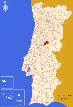
Pampilhosa da Serra (European Portuguese pronunciation: [pɐ̃piˈʎɔzɐ ðɐ ˈsɛʁɐ] ⓘ), officially the Town of Pampilhosa da Serra (Portuguese: Vila de Pampilhosa da Serra), is a town and a municipality in the Coimbra District, in Portugal. The population in 2011 was 4,481,[1] in an area of 396.46 km².[2]
Parishes
Administratively, the municipality is divided into 8 civil parishes (freguesias):[3]
- Cabril
- Dornelas do Zêzere
- Fajão - Vidual
- Janeiro de Baixo
- Pampilhosa da Serra
- Pessegueiro
- Portela do Fojo - Machio
- Unhais-o-Velho
Notable people
- António Fernandes (born 1962 in Pampilhosa da Serra) a chess player, became Grandmaster in 2003
- Tony Carreira (born 1963 in Armadouro) a Portuguese musician.
References
- ^ Instituto Nacional de Estatística
- ^ "Áreas das freguesias, concelhos, distritos e país". Archived from the original on 2018-11-05. Retrieved 2018-11-05.
- ^ Diário da República. "Law nr. 11-A/2013, page 552 88" (pdf) (in Portuguese). Retrieved 29 July 2014.