Puerto Rico Highway 52
  Highway 52 | ||||
|---|---|---|---|---|
| Ruta 52 | ||||
| Autopista Luis A. Ferré | ||||
PR-52 highlighted in red | ||||
| Route information | ||||
| Maintained by Metropistas | ||||
| Length | 108.5 km[1] (67.4 mi) | |||
| Existed | 1968[2]–present | |||
| Major junctions | ||||
| South end | ||||
| North end | ||||
| Location | ||||
| Country | United States | |||
| Territory | Puerto Rico | |||
| Municipalities | Ponce, Juana Díaz, Santa Isabel, Salinas, Cayey, Caguas, Trujillo Alto, San Juan | |||
| Highway system | ||||
| ||||
Puerto Rico Highway 52 (PR-52), a major toll road in Puerto Rico, is also known as Autopista Luis A. Ferré. It was formerly called Expreso Las Américas. It runs from PR-1 in southwest Río Piedras and heads south until it intersects with highway PR-2 in Ponce.[3] PR-52 is Puerto Rico's longest and second most traveled tollway. The road is mostly a 2-lane road in each direction. Toll stations are located in San Juan, Caguas, Salinas, Juana Díaz, and Ponce. The speed limit from San Juan to Caguas is 55 miles per hour (89 km/h). From Caguas to Salinas, it is 45 miles per hour (72 km/h), and from Salinas to Ponce, it is 65 miles per hour (105 km/h).
Route description
At its north end, the short PR-18 continues from north to south along PR-52 towards Hato Rey and Santurce. This short segment is known as Expreso Las Américas, the only segment of the route still unofficially bearing this name, since PR-18 is now officially named Roberto Sánchez Vilella Expressway. The combined route of PR-18 and PR-52 runs concurrent with the unsigned US Interstate Highway PRI-1. PR-52 continues southward along Cupey and Caimito, crossing the westernmost edge of the Sierra de Luquillo in Trujillo Alto on the way to Caguas. In Caguas, it crosses the Valley of Caguas, where it functions as a north-south bypass for local traffic, before elevating south into the Sierra de Cayey.
In Cayey, PR-52 passes extremely close to the municipality of Cidra between approximately kilometer markers 34 and 30. In fact, Exit 32 to Guavate is so close to the Cidra border that once the exit is taken and instead of going south to Guavate and Patillas through PR-184, going north it quickly ends at PR-1 and a welcome sign to Cidra is shown. The tollway itself never enters Cidra itself, but PR-1 (the parallel road from Ponce to San Juan) does.
The speed limit is reduced in the section between Cayey and Salinas crosses the Sierra de Cayey, resulting in a more curvy and hilly section than the other sections of the highway. Located at the orographic lift of the Cordillera Central, it also experiences more fog and lower visibility than the rest of the road due to the altitude. This is also the highest point of the route. One of Puerto Rico's only 2 rest areas is located on this section of the expressway in Salinas. (map) The other rest area is located on PR-53 (northbound only) near Humacao/Naguabo municipality border and, just like the rest area on PR-52, it has no operating facilities. (map) The rest area does provide view of a pair of important landmarks, the Monumento al Jíbaro Puertorriqueño and the famous Tetas de Cayey.
Beginning at the leeward side of Salinas, between here and Ponce, PR-52 crosses the southern coastal plain of Puerto Rico, crossing Santa Isabel and Juana Díaz. The route finally enters the urban area of Ponce at barrio Sabanetas, marked by the famous Letras de Ponce landmark.
-
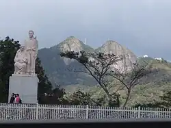 The Monumento al Jíbaro Puertorriqueño and Las Tetas de Cayey
 -
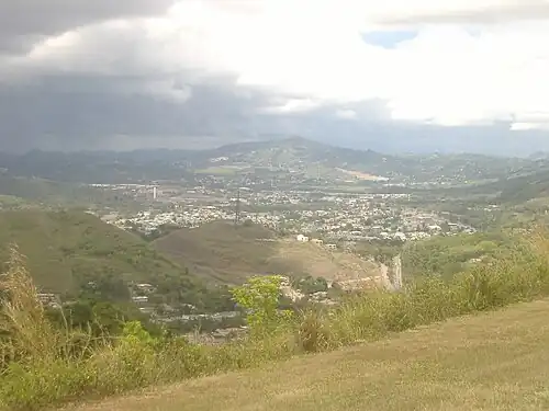 View from PR-52 in Cayey
 -
 A Toyota Tacoma pick-up truck on PR-52 south, with water and flag, after Hurricane Maria (2017)
 -
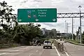
.jpg) Heading south in San Juan
Heading south in San Juan -
.jpg) Heading south in Trujillo Alto
Heading south in Trujillo Alto -
.jpg) Heading south in Caguas
Heading south in Caguas -
.jpg) Heading southwest in Cayey
Heading southwest in Cayey -
-1.jpg) Heading southwest in Salinas
Heading southwest in Salinas -
.jpg) Heading northeast in Santa Isabel
Heading northeast in Santa Isabel -
.jpg) Heading west in Ponce
Heading west in Ponce
Express lanes
In 2021, the Puerto Rico Department of Transportation and Public Works and the Puerto Rico Highways and Transportation Authority inaugurated express lanes with dynamic tolling (DTL) between San Juan and Caguas to help alleviate traffic congestion during peak hours.[4] These reversible lanes extends from PR-18, near Río Piedras Medical Center, to the Caguas Norte Toll Plaza with a variable rate between $0.50 and $6.00 per direction.[5] The speed limit on the nearly 14-kilometer route ranges between 50 and 55 miles per hour (80–90 km/h). It is expected that in the long term the lanes will be extended to PR-30 heading to Gurabo.[6]
History
The building of this 108-kilometer (67 mi)[7] expressway took place during the administration of governor Luis A. Ferré, who was trained as a civil engineer himself. [8] It was built at a cost of $125 million.[9] PR-52 was Puerto Rico's first toll road ever. Construction for this road started in October 1968 during the administration of governor Roberto Sánchez Vilella, also a trained engineer, and continued during Luis Ferre's tenure. It was then named Autopista Las Américas, and it was planned to run from San Juan to Ponce.[2] The expressway is currently the longest in the island, but this will change when the 83-km-long PR-22 extends to Aguadilla. In March 1969 the roadway became a tolled expressway. The Puerto Rico Highway and Transportation Authority reports that tolls were added to the highway to speed up its construction.[2] The road was completed in 1975 during the first administration of governor Rafael Hernández Colón.[10] On 9 December 1993, Law 118 was enacted which renamed the roadway Autopista Luis A. Ferré.[2] On 2007, construction of a suburban rail line connecting San Juan to Caguas to be built along PR-52 was announced by governor Aníbal Acevedo Vilá.[11] After years of planning stagnation and the implementation of new AMA bus routes along reversible lanes, the project was cancelled in 2017 due to lack of funding.[12]
The Las Américas section of PR-52/PR-18 along Hato Rey has been the setting of multiple mass protests in recent history. On February 21, 2000, more than 150,000 people participated in a mass protest against the United States Navy occupation of Vieques.[13] On 22 July 2019, more than half a million protestors shut down this section demanding the resignation of the then governor, Ricardo Rosselló, following a leaked Telegram chat between the governor and several members of his cabinet.[14]
Tolls
| Location | Toll[15] | Direction | AutoExpreso acceptance |
AutoExpreso replenishment (R) lane |
|---|---|---|---|---|
| Ponce | $1.00 | Two-way | ||
| Juana Díaz Oeste | $0.70 | Northbound | ||
| Juana Díaz Este | $0.70 | Southbound | ||
| Rampa Salinas | $0.50 | Northbound exit and southbound entrance (ramp) | ||
| Salinas | $1.10 | Two-way | ||
| Caguas Sur | $0.70 | Two-way | ||
| Caguas Norte | $1.00 | Two-way | ||
| Rampa Montehiedra | $0.50 | Northbound entrance (ramp) |
Exit list
-
 PR-52 south at its exit to PR-1 south in San Juan
 -
 PR-52 south approaching exits 1A-B to PR-177 in San Juan
 -
.jpg) PR-52 south at exit 2 to PR-199 in San Juan
PR-52 south at exit 2 to PR-199 in San Juan
| Municipality | Location | km[1] | mi | Exit | Destinations | Notes | ||
|---|---|---|---|---|---|---|---|---|
| Ponce | Canas | 108.5 | 67.4 | 108 | Southern terminus of Interstate PR1 and PR-52. Splits into PR-2. PR-2 exit 224. | |||
| 108.0 | 67.1 | |||||||
| Playa | 105.5 | 65.6 | Ponce Toll Plaza | |||||
| 104.9 | 65.2 | 104 | Signed as exits 104A (north) and 104B (south) | |||||
| Vayas | 100.9– 100.8 | 62.7– 62.6 | 101 | Signed as exits 101A (west) and 101B (east) | ||||
| Sabanetas | 98.0 | 60.9 | 98 | Signed as exits 98A (north) and 98B (south), access to San Lucas Hospital | ||||
| Coto Laurel | 95.5 | 59.3 | 95 | |||||
| Juana Díaz | Sabana Llana | 93.8 | 58.3 | Juana Díaz Oeste Toll Plaza (toll northbound only) | ||||
| Amuelas | 91.2 | 56.7 | 91 | |||||
| Río Cañas Abajo | 85.6 | 53.2 | Juana Díaz Este Toll Plaza (toll southbound only) | |||||
| Santa Isabel | Descalabrado | 81.4 | 50.6 | 80 | Southbound exit and northbound entrance | |||
| Descalabrado–Felicia 2 line | 77.7 | 48.3 | 77 | |||||
| Felicia 2 | 77.0– 76.9 | 47.8– 47.8 | 76 | |||||
| Salinas | Lapa | 66.2 | 41.1 | 65 | Toll on northbound off-ramp and southbound on-ramp | |||
| 61.5 | 38.2 | 61 | The northbound exit into the southwestern terminus of PR-53. | |||||
| 60.8 | 37.8 | 60 | Directional T interchange; The left southbound exit into the southwestern terminus of PR-53 | |||||
| 57.9 | 36.0 | Salinas Toll Plaza | ||||||
| 57.6– 57.5 | 35.8– 35.7 | 58 | Access via PR-1 / PR-712 | |||||
| Palmas–Lapa line | 49.2 | 30.6 | — | Rest Area | Northbound exit has access to PR-714. | |||
| Cayey | Monte Llano | 38.8 | 24.1 | 39 | Access to Centro Médico Menonita de Cayey | |||
| Beatriz | 32.2 | 20.0 | 32 | This exit is just a few feet away from the border of Cidra and Cayey | ||||
| Caguas | Turabo | 23.5 | 14.6 | Caguas Sur Toll Plaza | ||||
| 23.1 | 14.4 | 23 | ||||||
| Turabo–Cañaboncito line | 21.4 | 13.3 | 21 | The direct exit to Menonita Caguas Regional Hospital and Plaza del Carmen Mall | ||||
| Cañaboncito | 20.5– 20.4 | 12.7– 12.7 | 20 | Avenida Federico Degetau (PR-34) | Unsigned | |||
| Caguas barrio-pueblo | 19.3 | 12.0 | 19 | |||||
| Bairoa | 18.4 | 11.4 | 18 | The direct exit to Las Catalinas Mall. | ||||
| 16.1 | 10.0 | 15B | The exit from the southbound direction signed as Exit 14. | |||||
| 15.8 | 9.8 | 15A | The exit from the southbound direction signed as Exit 15. | |||||
| 15.5 | 9.6 | 15 | The exits from the northbound direction signed as 15A (North) and 15B (South). | |||||
| Río Cañas | 14.3– 14.2 | 8.9– 8.8 | Caguas Norte Toll Plaza | |||||
| 14.2 | 8.8 | 14 | Southbound exit | |||||
| Trujillo Alto |
No major junctions | |||||||
| San Juan | Caimito | 4.1 | 2.5 | 4 | PR-Avenida Montehiedra / PR-Camino Los Romero – Caimito | Toll on northbound on-ramp; signed as exits 4A and 4B southbound | ||
| Monacillo | 2.4 | 1.5 | 2 | |||||
| Monacillo Urbano | 0.9– 0.8 | 0.56– 0.50 | 1 | Southbound exits signed as 1A (west) and 1B (east) | ||||
| 0.3 | 0.19 | 0B | No northbound access to PR-1 south. | |||||
| 0.0 | 0.0 | 0A | Northern terminus of PR-52; PRI-1 continues northbound via PR-18. Access to Luis Muñoz Marín International Airport and hospitals. | |||||
1.000 mi = 1.609 km; 1.000 km = 0.621 mi
| ||||||||
See also
References
- ^ a b "PR-52" (Map). Google Maps. Retrieved 28 February 2020.
- ^ a b c d "Historia". Autoridad de Carreteras y Transportación. Archived from the original on 16 February 2009. Retrieved 2 May 2017.
- ^ Puerto Rico Department of Transportation and Public Works. "Datos de Transito 2000-2009" (in Spanish). Archived from the original on 1 April 2019. Retrieved 23 April 2019.
- ^ "Inauguran carril expreso en la PR-52". Diálogo UPR (in Spanish). 27 April 2021. Archived from the original on 25 October 2021. Retrieved 4 March 2024.
- ^ "Implantación Cobro de Peaje Carril Expreso de Caguas a San Juan (DTL PR-52 y 18)" (PDF) (in Spanish). Archived (PDF) from the original on 22 April 2021. Retrieved 4 March 2024.
- ^ "Inauguran el "carril expreso" en la autopista Luis A. Ferre con un costo de hasta $6". Primera Hora (in Spanish). 27 April 2021. Archived from the original on 27 April 2021. Retrieved 4 March 2024.
- ^ Guía de Carreteras Principales, Expresos y Autopistas. (In Spanish) Puerto Rico Autoridad de Carreteras y Transportación (ACT).
- ^ Ian James. "Former Puerto Rican Gov. Luis A Ferre dies." The Miami Herald. 22 October. 2003
- ^ Historia de las Carreteras de Puerto Rico. Primera Hora. 13 March 2006.
- ^ Legends of Puerto Rico Archived 2010-09-28 at the Wayback Machine
- ^ "San Juan - Caguas Rail Project" (PDF) (Press release). SEMALY. August 2004. Archived from the original (PDF) on 16 October 2005. Retrieved 15 August 2007.
- ^ "Caguas-San Juan light commuter train project derailed". News is My Business. 16 August 2017. Retrieved 12 January 2023.
- ^ ELNUEVODIA.COM, Por (22 July 2019). "Así fue la marcha de Vieques en el 2000 comparada con la de Rosselló". El Nuevo Día (in Spanish). Retrieved 15 August 2025.
- ^ "Cronología histórica del "Verano del 19″". Primera Hora (in Spanish). 20 July 2020. Retrieved 15 August 2025.
- ^ "Mapas y Tarifas". Metropistas (in Spanish). Archived from the original on 7 January 2025. Retrieved 26 February 2024.
External links
 Media related to Puerto Rico Highway 52 at Wikimedia Commons
| Signed | |
|---|---|
| Unsigned | |
| Lists | |
| Other | |
Routes in italics are no longer a part of the system. Major Interstates are highlighted. | |