Okstindbreen
| Okstindbreen | |
|---|---|
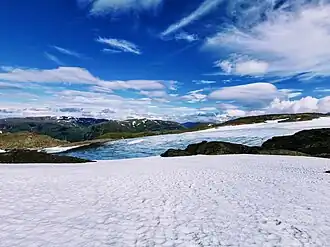 View of the westside glacier tongue | |
Interactive map of the glacier | |
| Location | Hemnes Municipality, Nordland, Norway |
| Coordinates | 65°59′15″N 14°08′53″E / 65.9874°N 14.1481°E |
| Area | 36.9 km2 (14.2 sq mi) (2022) |
| Highest elevation | 1,740 metres (5,710 ft) |
| Lowest elevation | 750 metres (2,460 ft) |
Okstindbreen is the eighth-largest glacier in mainland Norway.[1] Okstindbreen is also the largest of the 19 glaciers in the Okstindan area, which together covered about 46 km² in 2010.[2] The area of Okstindbreen itself decreased by 31% over 10 years, from 53.6 km² in 2012 to 36.9 km² in 2022.[1]
Okstindbreen comprises an ice field including Vestisen, Vestre Okstindbreen, Austre Okstindbreen, Bessedørbreen, Steikvassbreen, Vestre Svartfjellbreen, and Oksfjellbreen.[2] The largest outlet glacier from Okstindbreen is Austre Okstindbreen, measured to be 14 km² in 1996.[2] It drains towards the valley Oksfjelldalen, located northeast of Oksskolten, the highest mountain in Northern Norway.[2]
See also
References
- ^ a b Nesje, Atle. "Future state of Norwegian glaciers: Estimating glacier mass balance and equilibrium line responses to projected 21st century climate change". The Holocene. 33 (10): 1257–1271. doi:10.1177/09596836231183069. hdl:11250/3095156. ISSN 0959-6836.
- ^ a b c d Bakke, Jostein; Dahl, Svein Olaf; Paasche, Øyvind; Riis Simonsen, Joachim; Kvisvik, Bjørn; Bakke, Kristina; Nesje, Atle. "A complete record of Holocene glacier variability at Austre Okstindbreen, northern Norway: an integrated approach". Quaternary Science Reviews. 29 (9–10): 1246–1262. doi:10.1016/j.quascirev.2010.02.012.