North Memphis, Memphis, Tennessee
North Memphis | |
|---|---|
 Handwerker Gingerbread Playhouse | |
| Country | United States |
| State | Tennessee |
| Counties | Shelby |
| Settled | 1937 |
| Incorporated | 1942 |
| Government | |
| • Mayor | Paul Young |
| Zip code | 38108-38128 |
| Area code | 901 |
North Memphis is one of the five defined districts of Memphis, Tennessee. It includes smaller neighborhoods such as Klondike, New Chicago, Douglass, Hyde Park, Hollywood, Nutbush, Binghampton, Smokey City, Scutterfeld, Frayser, and Raleigh.
History
North Memphis flourished during the 19th and 20th centuries. Klondike and Smokey City are two of the oldest African American elite communities[2] in Memphis.[3] Historic neighborhoods like Speedway Terrace, Vollintine-Evergreen, and Shelby Forest were home to wealthy families and a vibrant manufacturing industry.
In 1887, Memphis Artesian Water Company in North Memphis began digging artesian wells to create a modern sewer system. The facility was eventually torn down to expand parking for St. Jude Children's Research Hospital[4]
On January 19, 1937, the Firestone Tire and Rubber Company opened what would become its most productive factory, located in the New Chicago neighborhood of Memphis.[5] In 1942, in Frayser on 260 acres of land, International Harvester built the largest farm-equipment manufacturing plant in the South.[6]
By the end of the 20th century, the industrial hub in North Memphis steadily declined as manufacturing jobs disappeared due to deindustrialization. Companies that closed their operations include Firestone, International Harvester, Cleo, Schering-Plough, Maybelline, Velsicol Chemical Corporation, Kimberly-Clark and Chemtura. The companies still operating were chemical plants known for heavy pollution. The Douglass community still had eight polluting facilities.[7]
Music
North Memphis produced musicians like Laura Dukes, Gary Harrison, Greg Cartwright and rappers like Project Pat, Juicy J, Yo Gotti, Snootie Wild, Ceo D.We$t, Frayser Boy, Lil Wyte, Cities Aviv and C-Mo.
Gallery
-

-
 Speedway Terrace
 -
 Firestone Park in Frayser
 -
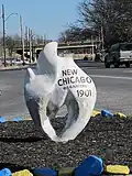 New Chicago
 -
 Vollintine Evergreen
 -
 Shelby Forest
References
- ^ "2010 United States Census Gazetteer for Places: January 1, 2010" (text). 2010 United States Census. United States Census Bureau. April 2010. Retrieved August 1, 2012.
- ^ Bond, Beverly G.; Sherman, Janann (January 1, 2003). "Memphis: In Black and White". Arcadia Publishing. p. 71. Retrieved July 29, 2025 – via Google Books.
- ^ "Klondike/Smokey City CDC - Memphis, TN 38107". Neighborhoodlink.com. Retrieved July 29, 2025.
- ^ "Memphis, Tenn. Pumping Station. City Artesian Water Dept. - postcard mailed 1910". Flickr.com. March 14, 2012. Retrieved July 29, 2025.
- ^ "Firestone Tire and Rubber Company". Archived from the original on March 4, 2016. Retrieved September 22, 2014.
- ^ "The Memphis Flyer: Cover Story - December 4, 1997". Memphisflyer.com. Retrieved July 29, 2025.
- ^ "Toxic Shock". Memphisflyer.com. Retrieved July 29, 2025.