Nerestce
Nerestce | |
|---|---|
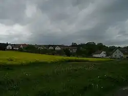 The village of Horní Nerestce | |
 Flag  Coat of arms | |
 Nerestce Location in the Czech Republic | |
| Coordinates: 49°30′2″N 14°3′46″E / 49.50056°N 14.06278°E | |
| Country | |
| Region | South Bohemian |
| District | Písek |
| First mentioned | 1227 |
| Area | |
• Total | 4.68 km2 (1.81 sq mi) |
| Elevation | 435 m (1,427 ft) |
| Population (2025-01-01)[1] | |
• Total | 105 |
| • Density | 22/km2 (58/sq mi) |
| Time zone | UTC+1 (CET) |
| • Summer (DST) | UTC+2 (CEST) |
| Postal code | 398 04 |
| Website | www |
Nerestce is a municipality in Písek District in the South Bohemian Region of the Czech Republic. It has about 100 inhabitants.
Administrative division
Nerestce consists of two municipal parts (in brackets population according to the 2021 census):[2]
- Dolní Nerestce (77)
- Horní Nerestce (25)
Etymology
The initial name of the village was Neřestce. The name was derived from the Czech word neřestníci, which can be translated as 'vice people', 'immoral people'.[3]
Geography
Nerestce is located about 22 kilometres (14 mi) north of Písek and 64 km (40 mi) south of Prague. It lies in the Benešov Uplands. The highest point is at 515 metres (1,690 ft) above sea level. The Skalice River flows through the municipality.
History
The first written mention of Nerestce is from 1227, when it was owned by the St. George's Convent in Prague. At this time, Dolní Nerestce and Horní Nerestce were not yet distinguished. From 1474, the village belonged to the Čimelice estate and was owned by various less important noble families.[4][5]
Demographics
|
|
| ||||||||||||||||||||||||||||||||||||||||||||||||||||||
| Source: Censuses[6][7] | ||||||||||||||||||||||||||||||||||||||||||||||||||||||||
Transport
The D4 motorway from Prague to Písek runs through the municipality.
Sights
.jpg)
The main landmark of Nerestce is the former Dolní Nerestce Castle. Originally a Renaissance fortress froun around 1600, it was rebuilt into a Baroque castle at the end of the 17th century and in the first half of the 18th century. In the 20th century, it was converted into apartments. Sgraffito decoration and vaults have been preserved in the east wing of the castle.[5]
A cultural and technical monument is the three-arch stone bridge. It was built in 1814–1816 on the site of an older bridge and used to be decorated with valuable Baroque statues of saints from the mid-18th century. Today, the statues are in the depository of the municipality of Čimelice. In 1963, a new reinforced concrete bridge was built next to the historic bridge and the importance of the old bridge decreased.[8]
References
- ^ "Population of Municipalities – 1 January 2025". Czech Statistical Office. 2025-05-16.
- ^ "Public Census 2021 – basic data". Public Database (in Czech). Czech Statistical Office. 2022.
- ^ Profous, Antonín (1951). Místní jména v Čechách III: M–Ř (in Czech). p. 209.
- ^ "Historie" (in Czech). Obec Nerestce. Retrieved 2025-07-30.
- ^ a b "Zámek" (in Czech). National Heritage Institute. Retrieved 2025-07-30.
- ^ "Historický lexikon obcí České republiky 1869–2011" (in Czech). Czech Statistical Office. 2015-12-21.
- ^ "Population Census 2021: Population by sex". Public Database. Czech Statistical Office. 2021-03-27.
- ^ "Silniční most se sochami" (in Czech). National Heritage Institute. Retrieved 2025-07-30.