Nejepín
Nejepín | |
|---|---|
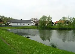 Pivovarský Pond | |
 Flag  Coat of arms | |
 Nejepín Location in the Czech Republic | |
| Coordinates: 49°44′40″N 15°36′2″E / 49.74444°N 15.60056°E | |
| Country | |
| Region | Vysočina |
| District | Havlíčkův Brod |
| First mentioned | 1488 |
| Area | |
• Total | 3.79 km2 (1.46 sq mi) |
| Elevation | 524 m (1,719 ft) |
| Population (2025-01-01)[1] | |
• Total | 96 |
| • Density | 25/km2 (66/sq mi) |
| Time zone | UTC+1 (CET) |
| • Summer (DST) | UTC+2 (CEST) |
| Postal code | 583 01 |
| Website | www |
Nejepín is a municipality and village in Havlíčkův Brod District in the Vysočina Region of the Czech Republic. It has about 100 inhabitants.
Nejepín lies approximately 15 kilometres (9 mi) north of Havlíčkův Brod, 38 km (24 mi) north of Jihlava, and 94 km (58 mi) south-east of Prague.
Demographics
| Year | Pop. | ±% |
|---|---|---|
| 1869 | 276 | — |
| 1880 | 277 | +0.4% |
| 1890 | 253 | −8.7% |
| 1900 | 222 | −12.3% |
| 1910 | 219 | −1.4% |
| 1921 | 235 | +7.3% |
| 1930 | 206 | −12.3% |
| 1950 | 153 | −25.7% |
| 1961 | 160 | +4.6% |
| 1970 | 157 | −1.9% |
| 1980 | 105 | −33.1% |
| 1991 | 84 | −20.0% |
| 2001 | 64 | −23.8% |
| 2011 | 57 | −10.9% |
| 2021 | 66 | +15.8% |
| Source: Censuses[2][3] | ||
References
- ^ "Population of Municipalities – 1 January 2025". Czech Statistical Office. 2025-05-16.
- ^ "Historický lexikon obcí České republiky 1869–2011" (in Czech). Czech Statistical Office. 2015-12-21.
- ^ "Population Census 2021: Population by sex". Public Database. Czech Statistical Office. 2021-03-27.
External links
Wikimedia Commons has media related to Nejepín.