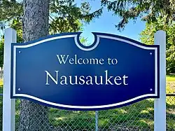
Nausauket, Rhode Island
Nausauket, Rhode Island is a coastal neighborhood located in Warwick, Rhode Island, in the United States. Nausauket is bounded to the south by Greenwich Bay and to the west by Apponaug Cove. It is delimited by Buttonwoods to the east and Rhode Island Route 117 to the north. Nausauket is known for its calm, shallow waters and abundant shellfish beds. [1]
History

The Nausauket area was originally settled by the sub-tribes of the Narragansett Indian Nation.[2] [3] The name "Nausauket" means "at the second outlet" or "between outlets" in the Narragansett language of the Narragansett people.[4] The rich shellfish beds of Greenwich Bay and Apponaug Cove provided the earliest inhabitants with a plentiful food source of soft shell clams, quahogs and oysters.[5]
In 1642, the area was purchased from the Narragansetts by a group of Englishmen (including Samuel Gorton). The sale encompassed 90 square miles of land in central Rhode Island and was known as the "Shawomet Purchase."[6]
By the end of the 17th century, the land in Nausauket had been cultivated into farmland by European settlers. Taylor Farm, located on the south-western section of Nausauket, was one of the farms located there.[7] [8] On what was once Taylor Farm, just off present day Tiernan street, lies the Ambrose Taylor historical cemetery lot #106, which has 21 graves ranging from 1823 to 1907. Ambrose Taylor, for whom the cemetery is named, was one of the original members of the Pawtuxet Rangers. [9][10] The farms in Nausauket were likely tenant farms, as most farms in Rhode Island operated in this manner.[11] Given it's close proximity to the ocean, the sandy soil [12] was not ideal for growing crops. For additional sustenance, the settlers raised cattle and other livestock.[13] The salt marsh grasses surrounding Baker Creek (originally known as Weeweonk or Waw-weonke creek)[14] were used extensively as livestock feed during the harsh winters.[15]
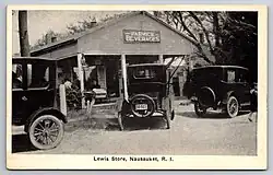
Around 1870, the area transitioned from farmland into a popular summer campground that existed until the 1910's. [15] The campground provided spaces for families to pitch tents, with many using surplus army tents from the Civil War. Visitors to Nausauket came by steamboat or via horse-drawn station wagon from the Apponaug train station [16] (formerly located at 3666 West Shore Road/Station Street). [17] In 1885 a store was constructed at 478 Nausauket Rd [18] to service the campground. It operated as Lewis Store in the 1920's, Smith's Grocery in the 1930's and 40's, then Green's Variety in the 1950's, followed by a news distributors office, eventually becoming a private residence, which still exists today. [19]
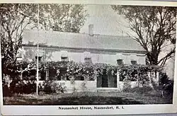
In addition to the campground, the farm house at Nausauket Farm[20] (located across from Taylor farm, between Nausauket Road and Baker Creek, owned by Oliver Johnson)[21] became a small hotel, Nausauket House, where guests could stay.[22]
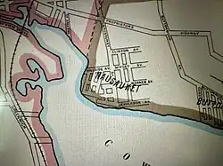
Beginning in the early 1910's, the land was subdivided, sold and further developed. Many summer beach cottages were built during that time period.[23] A map of Nausauket from 1922, from the Sanborn Fire Insurance shows some of the early street names.[24]
Even though most of Nausauket is not located within a flood zone [25] The Hurricane of 1938 and Hurricane Carol (1954) still had a significant impact on the community. In 1938, the 14-18 foot storm surge washed away many homes that were never rebuilt.[26] Most of the City of Warwick was left without power and telephone service for over 100 days.[27] Timber jetties and drainage channels were built after the hurricane to protect the coastline from future storms. These jetties did protect the beach from being swept away during Hurricane Carol, however numerous cottages were still destroyed in the storm surge.[28] Even now, rising waters and changing currents cause issues in Nausauket. In 2017, a low-lying section of Edgewater Drive along Apponaug Cove was permanently closed to vehicular traffic due to coastal erosion.[29]
During the 1970s and 1980s the neighborhood experienced some decline [30] but has since seen a dramatic resurgence in popularity, due to its tranquil beach, [31] charming houses and its close proximity to Rhode Island T. F. Green International Airport, Warwick City Park and other local attractions. In March of 2020, Nausauket was featured on the HGTV series "Beach Hunters" episode "Ocean State Forever Home" (Season 8, Episode 1). [32]
Nausauket Beach
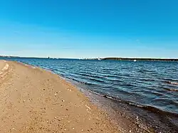
Nausauket beach is a small beach located at the end of Nausauket Road at a public access point to the shore. The beach is natural and unmaintained, without restrooms, trash receptacles, a parking area or lifeguards. [33] Often called a "hidden gem,"[34] it was named 1 of the 12 best beaches in Warwick, RI by TouristSecrets.com in 2024.[35] Due to improved water quality, the waters along the Nausauket shoreline were conditionally reopened to shellfish harvesting in September of 2022, for the first time in 20 years. [36]
Cedar Tree Point
Cedar Tree point is a sandy point located at the entrance to Apponaug Cove. It was the site of an ancient Native American settlement.[37] In 1924 the Cedar Tree Point Neighborhood Association was founded to promote a sense of community.[38]
Schools and colleges
The neighborhood has one public school within its borders. The E.G. Robertson School, formerly known as Nausauket School, was built in 1947.[39] The school is historically significant because it was the City of Warwick's first post-World War II modern school and served as a prototype for other schools across the country. It was featured in the January, 1947 issue of The Nation's Schools magazine and was recognized as a historically important municipal building by the City of Warwick in 1996.[40]
See also
References
- ^ "Maps and Books about Rhode Island's Blueways". exploreri.org. Retrieved May 17, 2025.
- ^ "What's in your neighborhood?". Johnston Sun Rise. September 23, 2010.
- ^ "Villages and Historic Places". warwickhistory.com. Retrieved May 16, 2025.
- ^ "American Indian Place Names In Rhode Island, Page 5". theusgenweb.org.
- ^ "The rich history of Narragansett Bay". October 2015.
- ^ "Then and Now: Historic Hindsight - the Shawomet Purchase Part 2". January 21, 2011.
- ^ "Maps and Books about Rhode Island's Blueways". exploreri.org. Retrieved May 16, 2025.
- ^ "Rhode Island Historical Cemeteries - Cemetery Details".
- ^ "Rhode Island Historical Cemeteries - Cemetery Details". rihistoriccemeteries.org.
- ^ Forsberg, Tim (March 9, 2017). "Johnston Historical Society helps restore cemetery of 'lost' Pawtuxet Ranger". Warwick Beacon. Retrieved May 17, 2025.
- ^ "The South Kingstown Planters: Country Gentry in Colonial Rhode Island". February 22, 2025.
- ^ "Archived copy" (PDF). Archived from the original (PDF) on September 27, 2024.
{{cite web}}: CS1 maint: archived copy as title (link) - ^ "Daily Life".
- ^ "The history of Warwick, Rhode Island: From its settlement in 1642 to the present time : Including accounts of the early settlement and development of its several villages, sketches of the origin and progress of the different churches of the town, &c., &c". 1875.
- ^ a b "Maps and Books about Rhode Island's Blueways". exploreri.org. Retrieved May 15, 2025.
- ^ "Buttonwoods 2 - an Ideal Spot".
- ^ "Apponaug Station - Warwick, Rhode Island | Railroad History".
- ^ "House for sale - 478 Nausauket Rd, Warwick, RI 02886". www.zillow.com.
- ^ "Warwick, RI".
- ^ "Nausauket Farm, Appinaug, R.I."
- ^ "Rhode Island Historical Preservation & Heritage Commission". Archived from the original on June 21, 2003. Retrieved July 30, 2025.
- ^ "Nausauket House, Nausauket, R.I."
- ^ "Internet Archive: Digital Library of Free & Borrowable Books, Movies, Music & Wayback Machine". archive.org.
- ^ "Image 1 of Sanborn Fire Insurance Map from Pawtuxet Valley and Warwick, Providence and Kent Counties, Rhode Island". Library of Congress, Washington, D.C. 20540 USA.
- ^ "FEMA Flood Map Service Center | Welcome!".
- ^ "Oakland Beach 3 - Hard Times and a Hurricane".
- ^ "The hurricane of 1938". March 28, 2012.
- ^ "A look back: 60 years ago, Hurricane Carol roared through R.I."
- ^ "End of road projects respond to rising sea level". July 10, 2014.
- ^ "Rhode Island Historical Cemeteries - Cemetery Details". rihistoriccemeteries.org. Retrieved May 17, 2025.
- ^ Bannister, Cara (January 21, 2024). "12 Spectacular Beaches to Visit in Warwick, Rhode Island". TouristSecrets. Retrieved May 17, 2025.
- ^ "Beach Hunters".
- ^ Island, Sea Grant Rhode. "The Rhode Island Shoreline". www.ri-shoreline.org. Retrieved May 15, 2025.
- ^ https://www.touristsecrets.com/destinations/united-states/rhode-island/12-spectacular-beaches-to-visit-in-warwick-rhode-island/
- ^ "12 Spectacular Beaches to Visit in Warwick, Rhode Island". January 21, 2024.
- ^ Chiappa, Claudia (September 1, 2022). "Shellfish harvesting expansion in Greenwich Bay conditionally approved". Providence Business News. Retrieved May 17, 2025.
- ^ "Maps and Books about Rhode Island's Blueways".
- ^ "Cedar Tree Point Association homepage". Archived from the original on June 30, 2004. Retrieved July 30, 2025.
- ^ "Archived copy" (PDF). Archived from the original (PDF) on July 1, 2024.
{{cite web}}: CS1 maint: archived copy as title (link) - ^ "S 1023". webserver.rilegislature.gov.