National Highway 85 (India)
 | ||||
|---|---|---|---|---|
Map of the National Highway in red | ||||
| Route information | ||||
| Part of | ||||
| Length | 468 km (291 mi) | |||
| Major junctions | ||||
| West end | Kochi, Kerala | |||
| East end | Thondi, Tamil Nadu | |||
| Location | ||||
| Country | India | |||
| States | Kerala, Tamil Nadu | |||
| Primary destinations | Ernakulam – Muvattupuzha – Kothamangalam – Adimali – Munnar – Devikulam – Bodinayakkanur – Theni – Usilampatti – Madurai – Sivaganga – Thondi | |||
| Highway system | ||||
| ||||
National Highway 85 (Old name NH 49 or NH 85) is a National Highway in southern India. It links Kochi in Kerala with Thondi, Tamil Nadu. The Kochi–Theni Greenfield Highway has been proposed to decongest the traffic between the Kochi and Munnar stretch on the NH 85.
Route
Starting from NH66 intersection in Kundanoor Junction at Maradu, Kochi, Ernakulam, Kolenchery, Muvattupuzha, Kothamangalam, Neriamangalam, Adimali, Munnar, Devikulam, Poopara in Kerala. Bodi, Theni, Andippatti, Usilampatti, Madurai, Thiruppuvanam, Sivagangai, Kalayarkoil, and ending at Thondi[1] at NH32 intersection in Tamil Nadu.
Gallery
-
.jpg) In Devikulam, Idukki district, Kerala
In Devikulam, Idukki district, Kerala -
.jpg) Gap Road in Udumbanchola, Idukki district, kerala
Gap Road in Udumbanchola, Idukki district, kerala
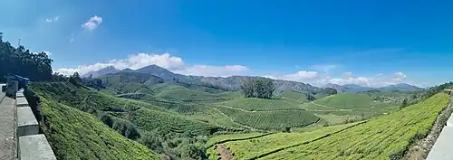
Tea plantations viewed from NH85 in Kannan Devan Hills, Idukki district, Kerala
See also
- List of national highways in India
- Kochi–Theni Greenfield Highway
- National Highways Development Project
References
- ^ "Rationalization of Numbering Systems of National Highways" (PDF). Govt of India. 28 April 2010. Retrieved 21 August 2011.
External links
- [1] NH 85 on MapsofIndia.com
- Playlist of the National Highway 85 (India) - YouTube


Secondary routes of | ||
|---|---|---|
| ||
| Secondary Routes of | ||