Mount Iriga
| Mount Iriga | |
|---|---|
| Mount Asog | |
 Mt. Asog as seen from Baao, Camarines Sur | |
| Highest point | |
| Elevation | 1,196 m (3,924 ft)[1] |
| Prominence | 1,009 m (3,310 ft) |
| Listing | Active volcanoes in the Philippines |
| Coordinates | 13°27′24″N 123°27′24″E / 13.45667°N 123.45667°E[1] |
| Geography | |
.svg.png) Mount Iriga Location in Luzon .svg.png) Mount Iriga Location in the Philippines | |
| Country | Philippines |
| Region | Bicol Region |
| Province | Camarines Sur |
| City/municipality | |
| Geology | |
| Rock age | Quaternary |
| Mountain type | Stratovolcano |
| Volcanic zone | Bicol Volcanic Chain |
| Last eruption | 1642 |
Mount Iriga, also known as Mount Asog, is a dormant stratovolcano in the province of Camarines Sur, in the Philippines.
It is a stratovolcano about a kilometer from Lake Buhi. It rises 1,196 m (3,924 ft) with a base diameter of 10 kilometres (6.2 mi).[1][2] It has a large crater formed due to a debris avalanche.
Mount Iriga, generally known for its phreatic explosions, erupted in 1628 and 1642.[2] After these eruptions, it remained dormant.
Gallery
-
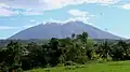 View from San Ramon, Iriga
 -
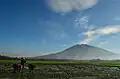 View from San Jose, Iriga
 -
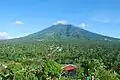 View from Perpetual Help, Iriga
 -
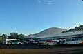 View from Iriga Central Terminal
See also
References
- ^ a b c "Iriga". Global Volcanism Program. Smithsonian Institution. Retrieved September 17, 2011.
- ^ a b "Mount Iriga". Philippine Institute of Volcanology and Seismology (PHIVOLCS). Archived from the original on September 1, 2011. Retrieved September 17, 2011.
External links
 Media related to Mount Iriga at Wikimedia Commons