Mount Carter (Idaho)
| Mount Carter | |
|---|---|
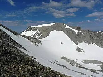 Mount Carter from Thompson Peak | |
| Highest point | |
| Elevation | 10,590 ft (3,230 m) |
| Prominence | 270 ft (82 m)[1] |
| Parent peak | Mickey's Spire |
| Coordinates | 44°08′23″N 115°01′06″W / 44.139835°N 115.018282°W |
| Geography | |
| Parent range | Sawtooth Range |
| Topo map | USGS Stanley Lake |
| Climbing | |
| Easiest route | Scramble, class 3 |
Mount Carter, standing at 10,590 feet (3,230 m) above sea level, is the seventh-highest peak in the Sawtooth Range of Idaho. Located in the Sawtooth Wilderness within the Sawtooth National Recreation Area, it lies on the border of Boise and Custer counties. The peak is located 0.32 mi (0.51 km) northwest of Mickey's Spire, its line parent, and 0.43 mi (0.69 km) west of Thompson Peak, the highest point in the range.[2][3][4]
See also
- List of peaks of the Sawtooth Range (Idaho)
- List of mountains of Idaho
- List of mountain peaks of Idaho
- List of mountain ranges in Idaho
References
- ^ "Mount Carter, Idaho". Peakbagger.com. Retrieved January 3, 2013.
- ^ "Mount Carter". SummitPost.org. Retrieved January 3, 2013.
- ^ "Mount Carter". Lists of John. Retrieved January 3, 2013.
- ^ Sawtooth National Forest (Map) (1998 ed.). Sawtooth National Forest, U.S. Forest Service.
State of Idaho | |
|---|---|
Boise (capital) | |
| Topics |
|
| Society | |
| Regions | |
| Larger cities | |
| Smaller cities | |
| Counties |
|