Monte Caburaí
| Monte Caburaí | |
|---|---|
| Highest point | |
| Elevation | 1,465 m (4,806 ft) |
| Coordinates | 05°16′20″N 60°12′43″W / 5.27222°N 60.21194°W |
| Geography | |
| Location | Roraima, Brazil - Guyana |
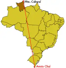
Monte Caburaí is a mountain located on the border between Brazil and Guyana standing at 1,465 metres (4,806 ft) above sea level. It is the northernmost point of Brazil and is the source of the Ailã River.[1]
See also
References
- ^ "Brasil em síntese - território - dados geográficos". IBGE (in Portuguese). Retrieved 2022-10-04.