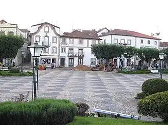
Monção
Monção | |
|---|---|
 | |
 Flag  Coat of arms | |
 | |
| Coordinates: 42°04′35″N 8°28′55″W / 42.07639°N 8.48194°W | |
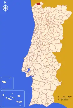
| Country | |
| Region | Norte |
| Intermunic. comm. | Alto Minho |
| District | Viana do Castelo |
| Parishes | 24 |
| Government | |
| • President | Antonio Barbosa (PSD) |
| Area | |
• Total | 211.31 km2 (81.59 sq mi) |
| Population (2011) | |
• Total | 19,230 |
| • Density | 91/km2 (240/sq mi) |
| Time zone | UTC+00:00 (WET) |
| • Summer (DST) | UTC+01:00 (WEST) |
| Website | www |
Monção (Portuguese pronunciation: [mõˈsɐ̃w] ⓘ; Spanish: Monzón) is a municipality in the district of Viana do Castelo in Portugal. The population in 2011 was 19,230,[1] in an area of 211.31 km2.[2] The current mayor is the Social Democrat António Barbosa. The municipal holiday is March 12.
Climate
Monção has a hot-summer Mediterranean climate (Köppen: Csa) with mild, rainy winters and hot dry summers. Although short, the summer season is dry enough to avoid being classified has a humid subtropical climate or an oceanic climate like nearby Vigo.
| Climate data for Monção (Valinha), 1991-2020 normals and extremes 1971-2020 | |||||||||||||
|---|---|---|---|---|---|---|---|---|---|---|---|---|---|
| Month | Jan | Feb | Mar | Apr | May | Jun | Jul | Aug | Sep | Oct | Nov | Dec | Year |
| Record high °C (°F) | 23.8 (74.8) |
26.8 (80.2) |
30.1 (86.2) |
33.2 (91.8) |
36.4 (97.5) |
40.9 (105.6) |
42.0 (107.6) |
41.9 (107.4) |
39.9 (103.8) |
36.0 (96.8) |
26.0 (78.8) |
25.6 (78.1) |
42.0 (107.6) |
| Mean daily maximum °C (°F) | 13.5 (56.3) |
15.4 (59.7) |
18.5 (65.3) |
20.1 (68.2) |
23.2 (73.8) |
26.7 (80.1) |
29.9 (85.8) |
30.2 (86.4) |
27.2 (81.0) |
21.8 (71.2) |
16.3 (61.3) |
13.8 (56.8) |
21.4 (70.5) |
| Daily mean °C (°F) | 9.2 (48.6) |
10.1 (50.2) |
12.9 (55.2) |
14.3 (57.7) |
17.1 (62.8) |
20.1 (68.2) |
22.6 (72.7) |
22.8 (73.0) |
20.5 (68.9) |
16.7 (62.1) |
12.1 (53.8) |
9.8 (49.6) |
15.7 (60.3) |
| Mean daily minimum °C (°F) | 5.0 (41.0) |
4.9 (40.8) |
7.2 (45.0) |
8.6 (47.5) |
11.0 (51.8) |
13.6 (56.5) |
15.4 (59.7) |
15.4 (59.7) |
13.8 (56.8) |
11.5 (52.7) |
7.8 (46.0) |
5.8 (42.4) |
10.0 (50.0) |
| Record low °C (°F) | −5.2 (22.6) |
−3.0 (26.6) |
−5.1 (22.8) |
−2.0 (28.4) |
−0.5 (31.1) |
3.8 (38.8) |
7.1 (44.8) |
7.0 (44.6) |
4.0 (39.2) |
1.0 (33.8) |
−1.5 (29.3) |
−3.4 (25.9) |
−5.2 (22.6) |
| Average precipitation mm (inches) | 142.8 (5.62) |
99.5 (3.92) |
105.2 (4.14) |
109.4 (4.31) |
93.2 (3.67) |
42.8 (1.69) |
22.2 (0.87) |
27.6 (1.09) |
67.4 (2.65) |
160.8 (6.33) |
157.1 (6.19) |
154.2 (6.07) |
1,182.2 (46.54) |
| Average precipitation days (≥ 1 mm) | 12.6 | 10.2 | 10.3 | 11.9 | 10.9 | 5.7 | 3.5 | 4.1 | 6.4 | 11.7 | 12.8 | 12.4 | 112.5 |
| Mean monthly sunshine hours | 98 | 105 | 151 | 168 | 196 | 240 | 282 | 265 | 207 | 148 | 118 | 85 | 2,063 |
| Source 1: Instituto de Meteorologia[3][4] | |||||||||||||
| Source 2: Portuguese Environment Agency (for sunshine 1967-1990)[5] | |||||||||||||
Notable people
- Joaquim Pereira Pimenta de Castro (1846 in Pias, Monção – 1918) an army officer and politician; 10th Count of Pimenta de Castro
- José Gomes Temporão (born 1951) a Brazilian public health physician and Minister of Health of Brazil, 2007 to 2010.
- Fernando Vilar (born 1954 in Lara, Monção) a Uruguayan journalist and news anchor.
Population
| Population of Monção Municipality (1801–2011) | ||||||||
|---|---|---|---|---|---|---|---|---|
| 1801 | 1849 | 1900 | 1930 | 1960 | 1981 | 1991 | 2001 | 2011 |
| 12,095 | 14,983 | 26,077 | 24,585 | 27,393 | 23,799 | 21,799 | 19,956 | 19,230 |
Parishes
Administratively, the municipality is divided into 24 civil parishes (freguesias):[6]
- Abedim
- Anhões e Luzio
- Barbeita
- Barroças e Taias
- Bela
- Cambeses
- Ceivães e Badim
- Lara
- Longos Vales
- Mazedo e Cortes
- Merufe
- Messegães, Valadares e Sá
- Monção e Troviscoso
- Moreira
- Pias
- Pinheiros
- Podame
- Portela
- Riba de Mouro
- Sago, Lordelo e Parada
- Segude
- Tangil
- Troporiz e Lapela
- Trute
See also
- Vinho Verde
- Brejoeira Palace
- Mercy Charitys's Church of Valadares
- Longos Vales's Monastery
- Castelo de Monção
References
- ^ Instituto Nacional de Estatística
- ^ "Áreas das freguesias, concelhos, distritos e país". Archived from the original on 2018-11-05. Retrieved 2018-11-05.
- ^ "Normal Climatológica – Monção / Estação de Fruticultura Vieira Natividade 1991-2020" (PDF). IPMA. Retrieved 21 August 2025.
- ^ "Monthly Averages for Valinha, Monção (1971–2000)" (PDF). Instituto de Meteorologia.
- ^ "Plano de Gestão da Região hidrográfica do Minho e Lima" (PDF). APA. p. 136. Retrieved 25 June 2021.
- ^ Diário da República. "Law nr. 11-A/2013, pages 552 75-76" (PDF) (in Portuguese). Retrieved 28 July 2014.
External links