Mawat, Iraq
Mawat
ماوەت ماوت | |
|---|---|
Village | |
 | |
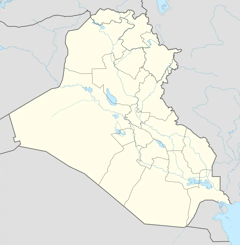 Mawat Location in Iraq 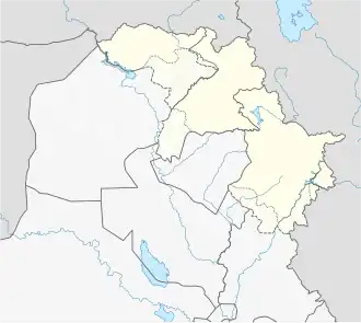 Mawat Mawat (Iraqi Kurdistan) | |
| Coordinates: 35°54′N 45°25′E / 35.900°N 45.417°E | |
| Country | |
| Region | |
| Governorate | Sulaymaniyah Governorate |
| District | Mawat District |
| Sub-district | Mawat |
| Population (2014)[1] | |
| • Urban | 1,464 |
| • Rural | 7,235 |
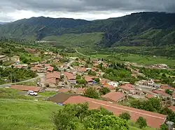
Mawat (Arabic: ماوت; Sorani Kurdish: ماوەت, romanized: Mawet)[2][3] is a village and subdistrict in Sulaymaniyah Governorate in the Kurdistan Region, Iraq. It is located in Mawat District, and serves as the district’s main town,[4] with a population of 1,464 urban residents and 7,235 rural residents.[5] The village is known for its steep and rugged terrain.[6]
Local economy
The main source of income for the population of Mawat is agriculture,[7] supported by the widespread presence of agricultural fields and orchards. However, cross-border smuggling of fuels and other goods also play a pivotal role in the economy,[8] this activity has consequently resulted in environmental impacts upon the Little Zab River.[9]
History and Conflicts
During the Iran Iraq War, the town came under key military operations such Operation Karbala 10, where Iranian and PUK forces advanced in Sulaymaniyah and captured areas around Mawat.[10][11] The area was heavily mined during this conflict.[12]
Following the war, the PKK began operations in the area due to its mountainous environment and its proximity to both Turkey and Iran. This has resulted in a period of Turkish air strikes in the region aimed at combatting the PKK presence.[13][14][15]
Ecology and Conservation
Nature Iraq’s Key Biodiversity Area report on Mawat highlights its ecological importance within the Zagros landscape, noting moderate grazing, native plant communities, and the need for habitat protection measures.[16]
References
- ^ Ali Sindi; Ramanathan Balakrishnan; Gerard Waite (July 2018). "Kurdistan Region of Iraq: Demographic Survey" (PDF). ReliefWeb. International Organization for Migration. p. 78. Retrieved 5 September 2021.
- ^ "'Me ji Tirkiyê re hinceta bombebarankirina Çiyayên Silêmaniyê nehişt'". Rûdaw (in Kurdish). 6 January 2018. Retrieved 21 December 2019.
- ^ "بە وێنە.. لەسنوری ماوەت چەندین دۆنم پوش و سووتا" (in Kurdish). Retrieved 21 December 2019.
- ^ "Kurdistan Region Statistics Office". Kurdistan Regional Government. Retrieved 28 July 2025.
- ^ Kurdistan Region of Iraq - Demographic Survey (PDF) (Report). Kurdistan Region Statistics Office (KRSO), IOM, UNFPA. 2018. Retrieved 28 July 2025.
- ^ Mawat: Biodiversity and Environmental Assessment Report (PDF) (Report). Nature Iraq. Retrieved 28 July 2025.
- ^ Mawat: Biodiversity and Environmental Assessment Report (PDF) (Report). Nature Iraq. Retrieved 28 July 2025.
- ^ Mawat: Biodiversity and Environmental Assessment Report (PDF) (Report). Nature Iraq. Retrieved 28 July 2025.
- ^ Mawat: Biodiversity and Environmental Assessment Report (PDF) (Report). Nature Iraq. Retrieved 28 July 2025.
- ^ Razoux, Pierre (3 November 2015). The Iran-Iraq War. Harvard University Press. ISBN 978-0-674-08863-4.
- ^ Sadri, Houman A. (16 April 1997). Revolutionary States, Leaders, and Foreign Relations: A Comparative Study of China, Cuba, and Iran. Bloomsbury Academic. ISBN 978-0-275-95321-8.
- ^ Mawat: Biodiversity and Environmental Assessment Report (PDF) (Report). Nature Iraq. Retrieved 28 July 2025.
- ^ Media, Gulan. "Turkish Airstrikes Target PKK in Sulaimani's Mawat District, Killing Three". Gulan Media. Retrieved 28 July 2025.
- ^ Kurdistan24. "Turkish airstrike hits a village in Sulaimani's Mawat". Archived from the original on 9 February 2025. Retrieved 28 July 2025.
{{cite news}}: CS1 maint: numeric names: authors list (link) - ^ "Suspected Turkish airstrike hit Sulaymaniyah's Mawat district with three PKK fights reported killed". 964media. 6 February 2025. Retrieved 28 July 2025.
- ^ Mawat: Biodiversity and Environmental Assessment Report (PDF) (Report). Nature Iraq. Retrieved 28 July 2025.