Mariánské Hory a Hulváky
Mariánské Hory a Hulváky | |
|---|---|
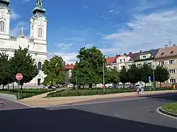 The square Stojanovo náměstí | |
 Flag  Coat of arms | |
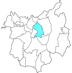 Location of Mariánské Hory a Hulváky in Ostrava | |
| Coordinates: 49°49′56″N 18°15′7″E / 49.83222°N 18.25194°E | |
| Country | |
| Region | Moravian-Silesian |
| Municipality | Ostrava |
| Area | |
• Total | 7.35 km2 (2.84 sq mi) |
| Population (2021)[1] | |
• Total | 11,629 |
| • Density | 1,600/km2 (4,100/sq mi) |
| Time zone | UTC+1 (CET) |
| • Summer (DST) | UTC+2 (CEST) |
| Postal code | 709 00 |
| Website | marianskehory |
Mariánské Hory a Hulváky is a borough of the city of Ostrava, Czech Republic. Situated in the north-central part of the city, it comprises the city parts Mariánské Hory, located in the northern part of the borough, and Hulváky, located in the southern part. Both were originally separate municipalities.[2] On 24 November 1990, it became one of the 23 self-governing boroughs of Ostrava.[3]
Etymology
The name Mariánské Hory means literally 'Marian mountains' in modern Czech, but hory is also an archaic term for a mining area.[4]
The name Hulváky likely derives from the German word Hohlweg, meaning 'sunken road'.[5]
Gallery
-
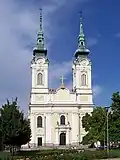 Church of Virgin Mary the Queen in Mariánské Hory
References
- ^ "Results of the 2021 Census - Open data". Public Database (in Czech). Czech Statistical Office. 27 March 2021.
- ^ "Historie" (in Czech). City of Ostrava. Retrieved 7 July 2025.
- ^ "Ostravské městské obvody". eOstrava.cz (in Czech). Retrieved 7 July 2025.
- ^ David, Jaroslav (2012). Paměť města - názvy míst Ostrava (in Czech) (1st ed.). Ostrava: University of Ostrava. p. 35. ISBN 978-80-7464-141-1.
- ^ "Hulváky a jejich pojmenování" (in Czech). City of Ostrava. Retrieved 7 July 2025.